Enable Location

We need your location to show you interesting places around you

Discover nearby places

Find interesting locations and hidden gems around you

Precise directions

Get accurate directions and distances to places

Your location is never shared with other users. It's only used when you tap the location button.

Cut River Bridge

Log in to your account

Start exploring — it's free

Trusted by 62,817 travelers worldwide

Continue with Google
Continue with Apple
or

We will send you a code to connect

By continuing, you accept our Terms and Conditions and our Privacy Policy

Check your inbox

We've sent a pincode in your inbox. Please enter the code below.

Cut River Bridge

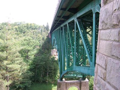
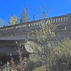
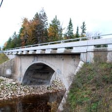
Cut River Bridge, Iron truss bridge in Mackinac County, Michigan

Cut River Bridge is an iron truss and beam bridge in Mackinac County, Michigan that spans a deep valley. The structure rises significantly above the riverbed and includes cantilever design with pedestrian walkways for crossing.

Construction started in 1941 but paused during World War II due to steel shortages, with completion finally occurring in 1947. The delay reflected how wartime demands disrupted civilian infrastructure projects across America.

The Michigan Legislature named the bridge after Navy SEAL Heath Michael Robinson, who died during military service in Afghanistan in 2011.

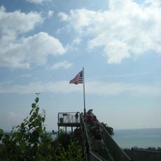
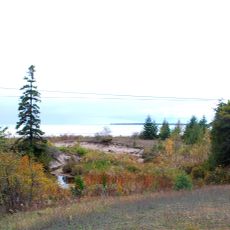
The bridge sits on US Highway 2 between Epoufette and Brevort and provides access to hiking trails and a roadside park with picnic facilities. Visitors can explore the trails on both sides and view the valley from multiple vantage points.

The bridge holds 888 tons of steel and ranks as one of only two cantilevered truss beam bridges in Michigan, making it a rare example of this specific design type. This approach allowed crossing the deep valley without placing support pillars in the middle.

The community of curious travelers

AroundUs brings together thousands of curated places, local tips, and hidden gems, enriched daily by 60,000 contributors worldwide.

Start exploring
Location
Official opening
1947
Made from material
iron
GPS coordinates
46.04500,-85.12520
Latest update
December 6, 2025 16:04
Michigan: the Great Lakes route between stunning nature and American history

From colorful cliffs to waterfalls, Michigan blends wild nature with historic buildings on the shores of the Great Lakes.

Around this place
Mackinac Bridge
United States of America

Mackinac Bridge

40 km
Waugoshance Light
United States of America

Waugoshance Light

28.8 km
Castle Rock
United States of America

Castle Rock

33.2 km
Wilderness State Park
United States of America

Wilderness State Park

38.7 km
Mackinac Bridge Walk
United States of America

Mackinac Bridge Walk

39.6 km
White Shoal Light
United States of America

White Shoal Light

22.6 km
Father Marquette National Memorial
United States of America

Father Marquette National Memorial

38.2 km
United States of America

Garlyn Zoo

13.9 km
Wawatam Lighthouse
United States of America

Wawatam Lighthouse

37.5 km
Straits of Mackinac Shipwreck Preserve
United States of America

Straits of Mackinac Shipwreck Preserve

38.8 km
The Headlands
United States of America

The Headlands

39.4 km
Straits State Park
United States of America

Straits State Park

38 km
St. Helena Island Light
United States of America

St. Helena Island Light

29.3 km
McGulpin Point Light
United States of America

McGulpin Point Light

39.6 km
Grays Reef Light Station
United States of America

Grays Reef Light Station

31.2 km
Lansing Shoals Light Station
United States of America

Lansing Shoals Light Station

37.3 km
St. Anthony's Rock
United States of America

St. Anthony's Rock

36.6 km
St. Ignace Mission
United States of America

St. Ignace Mission

36 km
Birch Lodge
United States of America

Birch Lodge

17.7 km
John Chambers House
United States of America

John Chambers House

36.9 km
Hiawatha Sportsman's Club 1931 Maintenance Building and Commissary
United States of America

Hiawatha Sportsman's Club 1931 Maintenance Building and Commissary

31.4 km
M-28–Tahquamenon River Bridge
United States of America

M-28–Tahquamenon River Bridge

35.9 km
Gros Cap Archaeological District
United States of America

Gros Cap Archaeological District

32.1 km
Marquette Street Archaeological District
United States of America

Marquette Street Archaeological District

36.2 km
Mackinac Trail – Carp River Bridge
United States of America

Mackinac Trail – Carp River Bridge

31.6 km
Manitou Lodge
United States of America

Manitou Lodge

26.7 km
Sacred Heart-Gros Cap Church
United States of America

Sacred Heart-Gros Cap Church

29.7 km
Top of The Lake Snowmobile Museum
United States of America

Top of The Lake Snowmobile Museum

25.7 km
Show the full map
« Cut River Bridge - Iron truss bridge in Mackinac County, Michigan » is provided by Around Us (aroundus.com). Images and texts are derived from Wikimedia project under a Creative Commons license. You are allowed to copy, distribute, and modify copies of this page, under the conditions set by the license, as long as this note is clearly visible.

Discover hidden gems everywhere you go!

From secret cafés to breathtaking viewpoints, skip the crowded tourist spots and find places that match your style. Our app makes it easy with voice search, smart filtering, route optimization, and insider tips from travelers worldwide. Download now for the complete mobile experience.

Around Us App Screenshot

A unique approach to discovering new places

Le Figaro

All the places worth exploring

France Info

A tailor-made excursion in just a few clicks

20 Minutes

Around Us
Travel Guide & Maps
Download

Send to your phone

QR Code
1

Open the camera app on your mobile.

2

Point at the QR code with your camera. A notification will appear.

3

Tap the notification to open the link.