Enable Location

We need your location to show you interesting places around you

Discover nearby places

Find interesting locations and hidden gems around you

Precise directions

Get accurate directions and distances to places

Your location is never shared with other users. It's only used when you tap the location button.

Waugoshance Light

Log in to your account

Start exploring — it's free

Trusted by 62,822 travelers worldwide

Continue with Google
Continue with Apple
or

We will send you a code to connect

By continuing, you accept our Terms and Conditions and our Privacy Policy

Check your inbox

We've sent a pincode in your inbox. Please enter the code below.

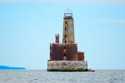
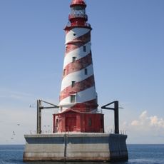
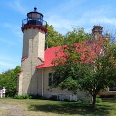
Waugoshance Light, Historic lighthouse in Lake Michigan, United States.

Waugoshance Light is a lighthouse in Lake Michigan located at the northern end of the lake and built as a cone-shaped steel tower. The tower was fitted with a Fresnel lens and served as a navigation marker for ships passing through the Strait of Mackinac.

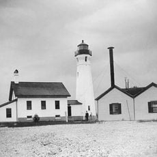
The lighthouse was built in 1851 and replaced an earlier light vessel on the Great Lakes. Operations ended in 1912, but the structure was repurposed afterward and remained part of regional transportation history.

This lighthouse represents an important landmark to Great Lakes mariners and shows how people adapted to dangerous shipping conditions. The structure tells a story of early engineering solutions that kept vessels safe through treacherous waters.

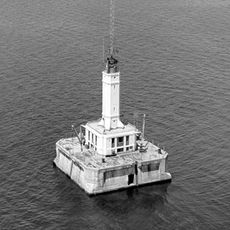
The lighthouse sits on a shoal in open water and is not easily reached from shore. Visitors should check water conditions before planning a visit and understand that access to the site is limited.

During World War II, the abandoned lighthouse was used by the U.S. Navy as a target for bombing practice. This unusual repurposing shows how forgotten structures found new roles during wartime.

The community of curious travelers

AroundUs brings together thousands of curated places, local tips, and hidden gems, enriched daily by 60,000 contributors worldwide.

Start exploring
Location
Inception
1850
Height
19 m
GPS coordinates
45.78733,-85.09169
Latest update
December 8, 2025 19:57
Around this place
Mackinac Bridge
United States of America

Mackinac Bridge

28.5 km
Fort Michilimackinac
United States of America

Fort Michilimackinac

27.6 km
Cut River Bridge
United States of America

Cut River Bridge

28.8 km
Wilderness State Park
United States of America

Wilderness State Park

15.8 km
Mackinac Bridge Walk
United States of America

Mackinac Bridge Walk

28.6 km
White Shoal Light
United States of America

White Shoal Light

6.9 km
Fort Michilimackinac State Park
United States of America

Fort Michilimackinac State Park

27.6 km
Straits of Mackinac Shipwreck Preserve
United States of America

Straits of Mackinac Shipwreck Preserve

26.8 km
The Headlands
United States of America

The Headlands

23.9 km
Straits State Park
United States of America

Straits State Park

29.8 km
St. Helena Island Light
United States of America

St. Helena Island Light

19.2 km
McGulpin Point Light
United States of America

McGulpin Point Light

24.7 km
Ile Aux Galets
United States of America

Ile Aux Galets

13.9 km
Grays Reef Light Station
United States of America

Grays Reef Light Station

5.4 km
St. Anthony's Rock
United States of America

St. Anthony's Rock

29.7 km
St. Ignace Mission
United States of America

St. Ignace Mission

29.4 km
Mama Mia's Pizza
United States of America

Mama Mia's Pizza

28.2 km
Forrest J. Stimpson House
United States of America

Forrest J. Stimpson House

28.3 km
Gros Cap Archaeological District
United States of America

Gros Cap Archaeological District

24.3 km
Marquette Street Archaeological District
United States of America

Marquette Street Archaeological District

29.2 km
Sacred Heart-Gros Cap Church
United States of America

Sacred Heart-Gros Cap Church

22.3 km
Old Mackinac Point Light
United States of America

Old Mackinac Point Light

28.1 km
The Wacky Taxidermy and Miniatures Museum
United States of America

The Wacky Taxidermy and Miniatures Museum

28.4 km
Mackinaw Bridge Museum
United States of America

Mackinaw Bridge Museum

28.2 km
Cross Village
United States of America

Cross Village

16.5 km
Michigan State Ferry System Historical Marker
United States of America

Michigan State Ferry System Historical Marker

28.4 km
Mackinaw City Historical Marker
United States of America

Mackinaw City Historical Marker

28.5 km
Gros Cap and Saint Helena Island Historical Marker
United States of America

Gros Cap and Saint Helena Island Historical Marker

24.1 km
Show the full map
« Waugoshance Light - Historic lighthouse in Lake Michigan, United States » is provided by Around Us (aroundus.com). Images and texts are derived from Wikimedia project under a Creative Commons license. You are allowed to copy, distribute, and modify copies of this page, under the conditions set by the license, as long as this note is clearly visible.

Discover hidden gems everywhere you go!

From secret cafés to breathtaking viewpoints, skip the crowded tourist spots and find places that match your style. Our app makes it easy with voice search, smart filtering, route optimization, and insider tips from travelers worldwide. Download now for the complete mobile experience.

Around Us App Screenshot

A unique approach to discovering new places

Le Figaro

All the places worth exploring

France Info

A tailor-made excursion in just a few clicks

20 Minutes

Around Us
Travel Guide & Maps
Download

Send to your phone

QR Code
1

Open the camera app on your mobile.

2

Point at the QR code with your camera. A notification will appear.

3

Tap the notification to open the link.