Enable Location

We need your location to show you interesting places around you

Discover nearby places

Find interesting locations and hidden gems around you

Precise directions

Get accurate directions and distances to places

Your location is never shared with other users. It's only used when you tap the location button.

Dorchester Heights

Log in to your account

Start exploring — it's free

Trusted by 61,820 travelers worldwide

Continue with Google
Continue with Apple
or

We will send you a code to connect

By continuing, you accept our Terms and Conditions and our Privacy Policy

Check your inbox

We've sent a pincode in your inbox. Please enter the code below.

Dorchester Heights, Historic district in South Boston, Massachusetts

Description

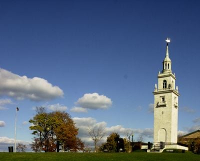
Dorchester Heights encompasses a 40-acre historic district featuring a 115-foot white marble monument designed by Peabody and Stearns, offering commanding views of Boston Harbor and the downtown skyline from its elevated position on Telegraph Hill.

History

On March 4, 1776, American forces under George Washington secretly fortified Dorchester Heights with artillery transported by Henry Knox from Fort Ticonderoga, forcing the British evacuation of Boston on March 17, 1776.

Culture

The site commemorates Evacuation Day, celebrated annually in Suffolk County on March 17th, marking the British withdrawal from Boston and representing a pivotal moment in American independence.

Practical

The monument is currently closed for restoration funded by the Great American Outdoors Act, though the surrounding Thomas Park grounds remain accessible to visitors despite the steep terrain challenges.

Did you know?

Archaeological excavations in the 1990s revealed original Revolutionary War fortifications beneath Thomas Park, confirming the site's authentic historical significance despite earlier beliefs that modern construction had destroyed them.

Location
GPS coordinates
42.33278,-71.04611
Latest update
July 25, 2025 19:20

AroundUs brings together thousands of curated places, local tips, and hidden gems, enriched daily by 60,000 contributors worldwide. Discover all places nearby (Massachusetts).

Around this place
Leader Bank Pavilion
United States of America

Leader Bank Pavilion

1.9 km
Cathedral of the Holy Cross
United States of America

Cathedral of the Holy Cross

2.1 km
Boston Children's Museum
United States of America

Boston Children's Museum

2.1 km
The Computer Museum, Boston
United States of America

The Computer Museum, Boston

2.1 km
James Blake House
United States of America

James Blake House

1.9 km
Carson Beach, South Boston
United States of America

Carson Beach, South Boston

750 m
Boston Tea Party Ships and Museum
United States of America

Boston Tea Party Ships and Museum

2.2 km
National Emerging Infectious Diseases Laboratories
United States of America

National Emerging Infectious Diseases Laboratories

1.9 km
Boston Fish Pier
United States of America

Boston Fish Pier

1.9 km
The Partisans
United States of America

The Partisans

1.8 km
Saint Augustine Chapel and Cemetery
United States of America

Saint Augustine Chapel and Cemetery

315 m
Statue of David Farragut
United States of America

Statue of David Farragut

1.9 km
Monan Park
United States of America

Monan Park

1.9 km
Fort Point Channel Historic District
United States of America

Fort Point Channel Historic District

2.1 km
Victoria's Diner
United States of America

Victoria's Diner

1.8 km
Cathedral of St. George Historic District
United States of America

Cathedral of St. George Historic District

351 m
Summer Street Bridge
United States of America

Summer Street Bridge

2.1 km
Statue of Edward Everett
United States of America

Statue of Edward Everett

1.9 km
Captain Lemuel Clap House
United States of America

Captain Lemuel Clap House

1.7 km
Clapp Houses
United States of America

Clapp Houses

1.7 km
Congress Street Fire Station
United States of America

Congress Street Fire Station

2 km
William Clapp House
United States of America

William Clapp House

1.7 km
Harrison Loring House
United States of America

Harrison Loring House

1.1 km
Bigelow School
United States of America

Bigelow School

2.2 km
United States of America

Old Harbor Reservation Parkways

372 m
South Boston Boat Clubs Historic District
United States of America

South Boston Boat Clubs Historic District

1.4 km
Quincy Grammar School
United States of America

Quincy Grammar School

2.2 km
Joshua Bates School
United States of America

Joshua Bates School

2.2 km
Show the full map
« Dorchester Heights - Historic district in South Boston, Massachusetts » is provided by Around Us (aroundus.com). Images and texts are derived from Wikimedia project under a Creative Commons license. You are allowed to copy, distribute, and modify copies of this page, under the conditions set by the license, as long as this note is clearly visible.

Discover hidden gems everywhere you go!

From secret cafés to breathtaking viewpoints, skip the crowded tourist spots and find places that match your style. Our app makes it easy with voice search, smart filtering, route optimization, and insider tips from travelers worldwide. Download now for the complete mobile experience.

Around Us App Screenshot

A unique approach to discovering new places

Le Figaro

All the places worth exploring

France Info

A tailor-made excursion in just a few clicks

20 Minutes

Around Us
Travel Guide & Maps
Download

Send to your phone

QR Code
1

Open the camera app on your mobile.

2

Point at the QR code with your camera. A notification will appear.

3

Tap the notification to open the link.