Enable Location

We need your location to show you interesting places around you

Discover nearby places

Find interesting locations and hidden gems around you

Precise directions

Get accurate directions and distances to places

Your location is never shared with other users. It's only used when you tap the location button.

Boston Fish Pier

Log in to your account

Start exploring — it's free

Trusted by 62,525 travelers worldwide

Continue with Google
Continue with Apple
or

We will send you a code to connect

By continuing, you accept our Terms and Conditions and our Privacy Policy

Check your inbox

We've sent a pincode in your inbox. Please enter the code below.

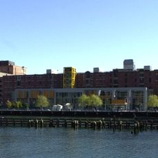
Boston Fish Pier, Historic Pier in Boston

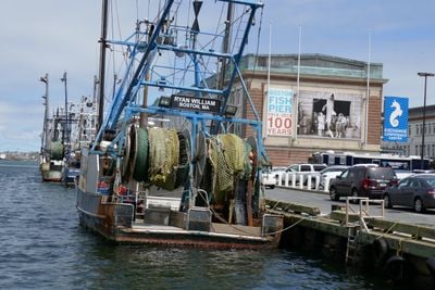
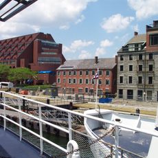
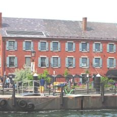
Boston Fish Pier is an active fishing port in southeast Boston where fishing boats land their daily catch. The pier extends about 1,200 feet (365 meters) along the water with two large steel and concrete buildings featuring decorative terra cotta elements and 44 storefronts where fish dealers and seafood businesses operate.

The pier was built between 1910 and 1912 and was one of the largest fish storage facilities in the world when it opened with capacity for up to 15 million pounds of fish. By the 1920s it processed hundreds of millions of pounds of fish yearly, peaked in 1969 with over 300 million pounds landed, and has been managed by the Massachusetts Port Authority since the 1970s.

The pier takes its name from the fishing trade that shaped it and continues to define its purpose. Visitors can observe how fishermen unload their catch daily and how this place keeps the city connected to the sea.

The best time to visit is during the day when fishermen are actively working and unloading their catch. Keep in mind that parts of the pier function as a working port and access for visitors may be restricted in some areas.

Polka Dog Bakery operates on the pier making dog treats from fish processing byproducts like cod skins. The company grew from a small kitchen to a large operation on the grounds and shows how traditional fishing sites support new business models.

The community of curious travelers

AroundUs brings together thousands of curated places, local tips, and hidden gems, enriched daily by 60,000 contributors worldwide.

Start exploring
Location
GPS coordinates
42.34917,-71.03944
Latest update
February 7, 2026 11:00
Around this place
New England Aquarium
United States of America

New England Aquarium

1.4 km
Rose Fitzgerald Kennedy Greenway
United States of America

Rose Fitzgerald Kennedy Greenway

1.3 km
Institute of Contemporary Art, Boston
United States of America

Institute of Contemporary Art, Boston

494 m
Leader Bank Pavilion
United States of America

Leader Bank Pavilion

219 m
Boston Children's Museum
United States of America

Boston Children's Museum

887 m
John Joseph Moakley United States Courthouse
United States of America

John Joseph Moakley United States Courthouse

811 m
Federal Reserve Bank Building
United States of America

Federal Reserve Bank Building

1.3 km
The Computer Museum, Boston
United States of America

The Computer Museum, Boston

909 m
United States lightship Nantucket
United States of America

United States lightship Nantucket

1.4 km
One International Place
United States of America

One International Place

1.3 km
One Financial Center
United States of America

One Financial Center

1.4 km
Boston Tea Party Ships and Museum
United States of America

Boston Tea Party Ships and Museum

1 km
State Street Bank Building
United States of America

State Street Bank Building

1.4 km
125 High Street
United States of America

125 High Street

1.3 km
Harbor Towers
United States of America

Harbor Towers

1.3 km
Roseway
United States of America

Roseway

732 m
Northern Avenue Bridge
United States of America

Northern Avenue Bridge

1 km
The Partisans
United States of America

The Partisans

285 m
Russia Wharf
United States of America

Russia Wharf

1.2 km
Keystone Building
United States of America

Keystone Building

1.4 km
United Shoe Machinery Corporation Building
United States of America

United Shoe Machinery Corporation Building

1.5 km
Fort Point Channel Historic District
United States of America

Fort Point Channel Historic District

939 m
Custom House Block
United States of America

Custom House Block

1.5 km
Chart House
United States of America

Chart House

1.5 km
Custom House District
United States of America

Custom House District

1.5 km
Summer Street Bridge
United States of America

Summer Street Bridge

1.1 km
Congress Street Fire Station
United States of America

Congress Street Fire Station

792 m
Bigelow School
United States of America

Bigelow School

765 m
Show the full map
« Boston Fish Pier - Historic Pier in Boston » is provided by Around Us (aroundus.com). Images and texts are derived from Wikimedia project under a Creative Commons license. You are allowed to copy, distribute, and modify copies of this page, under the conditions set by the license, as long as this note is clearly visible.

Discover hidden gems everywhere you go!

From secret cafés to breathtaking viewpoints, skip the crowded tourist spots and find places that match your style. Our app makes it easy with voice search, smart filtering, route optimization, and insider tips from travelers worldwide. Download now for the complete mobile experience.

Around Us App Screenshot

A unique approach to discovering new places

Le Figaro

All the places worth exploring

France Info

A tailor-made excursion in just a few clicks

20 Minutes

Around Us
Travel Guide & Maps
Download

Send to your phone

QR Code
1

Open the camera app on your mobile.

2

Point at the QR code with your camera. A notification will appear.

3

Tap the notification to open the link.