Dowagiac Woods

Log in to your account

AroundUs is a community-driven map of interesting places, built by curious explorers like you. It grows with every review, story, and photo you share.
Connect to save your favorite spots, contribute locations, and create personalized routes.
Continue with Google
Continue with Apple
Continue with X
Continue with Facebook
Continue with email
By continuing, you accept our Terms and Conditions and our Privacy Policy
Create an account
Add to collection
Map
Suggest a change
Share

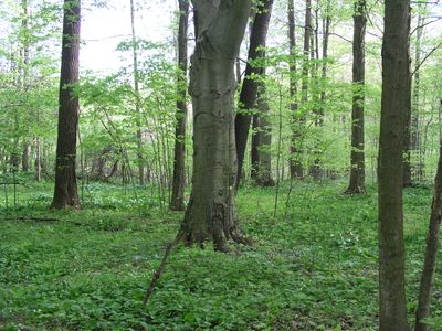
Dowagiac Woods, Protected area in Cass County, Michigan, US.

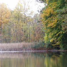
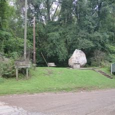
Dowagiac Woods is a nature sanctuary in Michigan covering about 384 acres of forest with hardwood swamps, floodplain forests, and various woodland types along the Dowagiac River. The land is crossed by trails and boardwalks that guide visitors across wet areas.

The sanctuary was founded in 1981 when the Michigan Nature Association purchased the initial forest areas to protect them from development. Additional woodland was added later to expand the protected region.

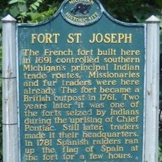
The name Dowagiac comes from the Potawatomi language and refers to a place where people traditionally gathered food and materials for survival. This heritage reflects the deep connection between the indigenous community and the forest's natural resources.

The site features about 2.5 miles of walking trails with wooden boardwalks that cross swampy areas and help visitors stay dry. Mountain bikes and dogs are not permitted to protect the natural environment.

This forest patch has never been plowed or clear-cut since the early 1800s, making it a rare reference for Michigan's original woodland. This uninterrupted forest cover has preserved nearly 50 native tree species found in the region.

Location: Michigan

GPS coordinates: 41.97600,-86.18230

Latest update: December 14, 2025 18:20

Photos
Around this place
Fort St. Joseph
United States of America

Fort St. Joseph

19.3 km
Moccasin Bluff Site
United States of America

Moccasin Bluff Site

20.3 km
Niles Scream Park
United States of America

Niles Scream Park

20.3 km
Fernwood Botanical Garden and Nature Preserve
United States of America

Fernwood Botanical Garden and Nature Preserve

18.4 km
First Methodist Episcopal Church of Pokagon
United States of America

First Methodist Episcopal Church of Pokagon

7.2 km
Shiloh House
United States of America

Shiloh House

24.9 km
Smith's Chapel
United States of America

Smith's Chapel

23.3 km
George Newton House
United States of America

George Newton House

18.2 km
Berrien Springs Courthouse
United States of America

Berrien Springs Courthouse

13.5 km
Water Street/Darden Road Bridge
United States of America

Water Street/Darden Road Bridge

28.3 km
Old Berrien County Courthouse Complex
United States of America

Old Berrien County Courthouse Complex

13.5 km
Crystal Springs Street–Dowagiac River Bridge
United States of America

Crystal Springs Street–Dowagiac River Bridge

6 km
North Watervliet Road – Paw Paw Lake Outlet Bridge
United States of America

North Watervliet Road – Paw Paw Lake Outlet Bridge

26.4 km
Niles Downtown Historic District
United States of America

Niles Downtown Historic District

17.4 km
Thomson Road–Air Line Railroad Bridge
United States of America

Thomson Road–Air Line Railroad Bridge

9.3 km
Fidelity Building
United States of America

Fidelity Building

27.3 km
Criffield-Whiteley House
United States of America

Criffield-Whiteley House

5.5 km
Ring Lardner House
United States of America

Ring Lardner House

18.1 km
Wendell P. and Harriet Rounds Robbins House
United States of America

Wendell P. and Harriet Rounds Robbins House

25.9 km
Buchanan North and West Neighborhoods Historic District
United States of America

Buchanan North and West Neighborhoods Historic District

22.3 km
Union Block
United States of America

Union Block

22.2 km
Martin's Super Markets
United States of America

Martin's Super Markets

27.7 km
Henry A. Chapin House
United States of America

Henry A. Chapin House

17.4 km
Ring Lardner Historical Marker
United States of America

Ring Lardner Historical Marker

18.1 km
Fort Saint Joseph Monument
United States of America

Fort Saint Joseph Monument

19.3 km
Fort Saint Joseph Historical Marker
United States of America

Fort Saint Joseph Historical Marker

19.3 km
Burnett's Post Historical Marker
United States of America

Burnett's Post Historical Marker

27.7 km
AMTK St. Joseph River Bridge
United States of America

AMTK St. Joseph River Bridge

16.9 km
Show the full map
Reviews

Visited this place? Tap the stars to rate it and share your experience / photos with the community! Try now! You can cancel it anytime.

« Dowagiac Woods - Protected area in Cass County, Michigan, US » is provided by Around Us (aroundus.com). Images and texts are derived from Wikimedia project under a Creative Commons license. You are allowed to copy, distribute, and modify copies of this page, under the conditions set by the license, as long as this note is clearly visible.

Discover hidden gems everywhere you go!

From secret cafés to breathtaking viewpoints, skip the crowded tourist spots and find places that match your style. Our app makes it easy with voice search, smart filtering, route optimization, and insider tips from travelers worldwide. Download now for the complete mobile experience.

Around Us App Screenshot

A unique approach to discovering new places

Le Figaro

All the places worth exploring

France Info

A tailor-made excursion in just a few clicks

20 Minutes