Enable Location

We need your location to show you interesting places around you

Discover nearby places

Find interesting locations and hidden gems around you

Precise directions

Get accurate directions and distances to places

Your location is never shared with other users. It's only used when you tap the location button.

Droeschers Mill

Log in to your account

Start exploring — it's free

Trusted by 63,103 travelers worldwide

Continue with Google
Continue with Apple
or

We will send you a code to connect

By continuing, you accept our Terms and Conditions and our Privacy Policy

Check your inbox

We've sent a pincode in your inbox. Please enter the code below.

Discussion Reviews 1 Photos
2k Popularity

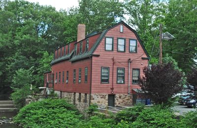
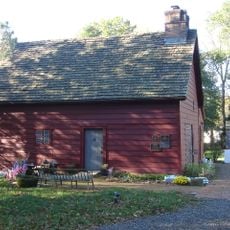
Droeschers Mill, Historic mill in Cranford, United States.

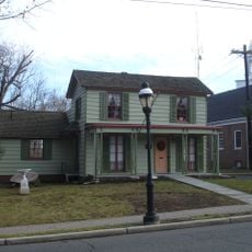
Droeschers Mill is a historic mill building located at 347 Lincoln Avenue East in Cranford along the Rahway River in Union County, New Jersey. The structure harnesses river water through an undershot water wheel to generate mechanical power for its operations.

The building was constructed in 1737 by Benjamin Williams as a sawmill powered by the river's water wheel. Over time it became one of the oldest continuously operating commercial structures in New Jersey.

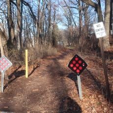
The mill sits on land that follows the path of the Naraticong Trail, originally used by the Unami people of the Lenape. The location connects visitors to the early trade routes that shaped the area's development.

The site can be accessed through the Cranford Riverwalk and Heritage Corridor, which runs from the Cranford Canoe Club heading south. Walking access is available along this established path that hugs the riverbank.

The structure has maintained its commercial operation while nearly all other mills on the Rahway River disappeared from the landscape. This continuity makes it a rare example of functioning water-powered machinery from the 18th century still in use today.

The community of curious travelers

AroundUs brings together thousands of curated places, local tips, and hidden gems, enriched daily by 60,000 contributors worldwide.

Start exploring
Location
GPS coordinates
40.65030,-74.30170
Latest update
December 14, 2025 09:40
Around this place
Baltusrol Golf Club
United States of America

Baltusrol Golf Club

6.5 km
Watchung Reservation
United States of America

Watchung Reservation

7.3 km
Union Watersphere
United States of America

Union Watersphere

5.8 km
Shady Rest Golf and Country Club
United States of America

Shady Rest Golf and Country Club

6 km
Union County Performing Arts Center
United States of America

Union County Performing Arts Center

4.9 km
Robinson Plantation House
United States of America

Robinson Plantation House

4.1 km
Shri Swaminarayan Mandir, New Jersey
United States of America

Shri Swaminarayan Mandir, New Jersey

5.1 km
Hersch Tower
United States of America

Hersch Tower

7.6 km
Homestead Farm at Oak Ridge
United States of America

Homestead Farm at Oak Ridge

6.2 km
Crane-Phillips House
United States of America

Crane-Phillips House

1.2 km
Elizabeth Public Library
United States of America

Elizabeth Public Library

7.4 km
Caldwell Parsonage
United States of America

Caldwell Parsonage

5.2 km
Connecticut Farms Presbyterian Church
United States of America

Connecticut Farms Presbyterian Church

5.3 km
Union County Courthouse
United States of America

Union County Courthouse

7.4 km
Rahway River Bridge
United States of America

Rahway River Bridge

5.2 km
Springfield Presbyterian Church
United States of America

Springfield Presbyterian Church

6.8 km
Deacon Andrew Hetfield House
United States of America

Deacon Andrew Hetfield House

5.3 km
Miller-Cory House
United States of America

Miller-Cory House

4.3 km
Union County Park Commission Administration Buildings
United States of America

Union County Park Commission Administration Buildings

5.5 km
Oswald J. Nitschke House
United States of America

Oswald J. Nitschke House

2.8 km
James Townley House
United States of America

James Townley House

6.6 km
John De Camp House
United States of America

John De Camp House

4.2 km
Liberty Hall
United States of America

Liberty Hall

6.9 km
Hutchings Homestead
United States of America

Hutchings Homestead

6.7 km
Merchants' and Drovers' Tavern
United States of America

Merchants' and Drovers' Tavern

4 km
34 Stockton Road, Summit, NJ
United States of America

34 Stockton Road, Summit, NJ

7.5 km
Sylvan Lane Footpath
United States of America

Sylvan Lane Footpath

6.7 km
Fanwood Park Historic District
United States of America

Fanwood Park Historic District

7.4 km
Show the full map
Reviews
Share your experience

No review yet

Discussions
Start a discussion...

No discussion yet

« Droeschers Mill - Historic mill in Cranford, United States » is provided by Around Us (aroundus.com). Images and texts are derived from Wikimedia project under a Creative Commons license. You are allowed to copy, distribute, and modify copies of this page, under the conditions set by the license, as long as this note is clearly visible.

Discover hidden gems everywhere you go!

From secret cafés to breathtaking viewpoints, skip the crowded tourist spots and find places that match your style. Our app makes it easy with voice search, smart filtering, route optimization, and insider tips from travelers worldwide. Download now for the complete mobile experience.

Around Us App Screenshot

A unique approach to discovering new places

Le Figaro

All the places worth exploring

France Info

A tailor-made excursion in just a few clicks

20 Minutes

Around Us
Travel Guide & Maps
Download

Send to your phone

QR Code
1

Open the camera app on your mobile.

2

Point at the QR code with your camera. A notification will appear.

3

Tap the notification to open the link.