Enable Location

We need your location to show you interesting places around you

Discover nearby places

Find interesting locations and hidden gems around you

Precise directions

Get accurate directions and distances to places

Your location is never shared with other users. It's only used when you tap the location button.

Connecticut Farms Presbyterian Church

Log in to your account

Start exploring — it's free

Trusted by 63,096 travelers worldwide

Continue with Google
Continue with Apple
or

We will send you a code to connect

By continuing, you accept our Terms and Conditions and our Privacy Policy

Check your inbox

We've sent a pincode in your inbox. Please enter the code below.

Connecticut Farms Presbyterian Church
Discussion Reviews 1 Photos
1.7k Popularity

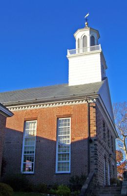
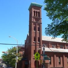
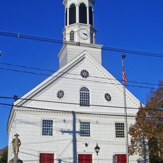
Connecticut Farms Presbyterian Church, Presbyterian church in Union, New Jersey

Connecticut Farms Presbyterian Church is a red brick building standing at the corner of Stuyvesant and Chestnut avenues with colonial architecture and white trim details. The property includes a cemetery on the grounds and provides parking for visitors.

The building was destroyed in 1780 during the Revolutionary War, but the congregation rebuilt it in 1782 using local materials and community support. This reconstruction shows the community's resilience after wartime destruction.

The congregation has hosted worship services continuously for over three centuries, with the building serving as a gathering place where neighborhood families return generation after generation. The red brick structure reflects the Presbyterian values of its founders and remains a spiritual center where people mark important life moments together.

The building sits near U.S. Route 22, making it easy to reach by car with ample parking available on the property. The church holds services throughout the week and welcomes visitors, with the congregation available to answer questions.

Hannah Caldwell, wife of a Continental Army chaplain, was killed in 1780 at the parsonage during an attack on the community, a reminder of the dangers of war for civilians. This tragic story remains closely tied to the building and congregation's history.

The community of curious travelers

AroundUs brings together thousands of curated places, local tips, and hidden gems, enriched daily by 60,000 contributors worldwide.

Start exploring
Location
Inception
1782
GPS coordinates
40.69330,-74.27390
Latest update
December 14, 2025 12:20
Around this place
Baltusrol Golf Club
United States of America

Baltusrol Golf Club

4.8 km
Paper Mill Playhouse
United States of America

Paper Mill Playhouse

4.9 km
Union Watersphere
United States of America

Union Watersphere

1 km
Weequahic Park
United States of America

Weequahic Park

6.1 km
Cora Hartshorn Arboretum and Bird Sanctuary
United States of America

Cora Hartshorn Arboretum and Bird Sanctuary

5.8 km
Hersch Tower
United States of America

Hersch Tower

5.8 km
Droeschers Mill
United States of America

Droeschers Mill

5.3 km
Eberhardt Hall, New Jersey Institute of Technology
United States of America

Eberhardt Hall, New Jersey Institute of Technology

5.7 km
St. Mary's Abbey Church
United States of America

St. Mary's Abbey Church

4.9 km
Crane-Phillips House
United States of America

Crane-Phillips House

4.2 km
Elizabeth Public Library
United States of America

Elizabeth Public Library

6.1 km
Caldwell Parsonage
United States of America

Caldwell Parsonage

824 m
Mid-Town Historic District
United States of America

Mid-Town Historic District

5.7 km
Union County Courthouse
United States of America

Union County Courthouse

6 km
Stone House by the Stone House Brook
United States of America

Stone House by the Stone House Brook

6 km
Springfield Presbyterian Church
United States of America

Springfield Presbyterian Church

3.6 km
South Orange Village Hall
United States of America

South Orange Village Hall

6 km
Woodruff House
United States of America

Woodruff House

4.6 km
United States of America

Eugene V. Kelly Carriage House

6.2 km
Short Hills Park Historic District
United States of America

Short Hills Park Historic District

5.6 km
Union County Park Commission Administration Buildings
United States of America

Union County Park Commission Administration Buildings

4.9 km
Oswald J. Nitschke House
United States of America

Oswald J. Nitschke House

2.6 km
James Townley House
United States of America

James Townley House

3.6 km
Charles N. Fowler House
United States of America

Charles N. Fowler House

5.3 km
Liberty Hall
United States of America

Liberty Hall

4.2 km
Hutchings Homestead
United States of America

Hutchings Homestead

3.4 km
18 Middle Ave, Summit, NJ
United States of America

18 Middle Ave, Summit, NJ

5.9 km
16 Middle Ave, Summit, NJ
United States of America

16 Middle Ave, Summit, NJ

5.9 km
Show the full map
Reviews
Share your experience

No review yet

Discussions
Start a discussion...

No discussion yet

« Connecticut Farms Presbyterian Church - Presbyterian church in Union, New Jersey » is provided by Around Us (aroundus.com). Images and texts are derived from Wikimedia project under a Creative Commons license. You are allowed to copy, distribute, and modify copies of this page, under the conditions set by the license, as long as this note is clearly visible.

Discover hidden gems everywhere you go!

From secret cafés to breathtaking viewpoints, skip the crowded tourist spots and find places that match your style. Our app makes it easy with voice search, smart filtering, route optimization, and insider tips from travelers worldwide. Download now for the complete mobile experience.

Around Us App Screenshot

A unique approach to discovering new places

Le Figaro

All the places worth exploring

France Info

A tailor-made excursion in just a few clicks

20 Minutes

Around Us
Travel Guide & Maps
Download

Send to your phone

QR Code
1

Open the camera app on your mobile.

2

Point at the QR code with your camera. A notification will appear.

3

Tap the notification to open the link.