Enable Location

We need your location to show you interesting places around you

Discover nearby places

Find interesting locations and hidden gems around you

Precise directions

Get accurate directions and distances to places

Your location is never shared with other users. It's only used when you tap the location button.

Ell Pond

Log in to your account

Start exploring — it's free

Trusted by 61,863 travelers worldwide

Continue with Google
Continue with Apple
or

We will send you a code to connect

By continuing, you accept our Terms and Conditions and our Privacy Policy

Check your inbox

We've sent a pincode in your inbox. Please enter the code below.

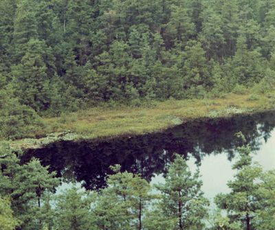
Ell Pond, National Natural Landmark in Hopkinton, Rhode Island.

Description

Ell Pond is a protected natural area in Hopkinton, Rhode Island, featuring a kettle hole pond ringed by red maple and Atlantic white cypress trees. The site spans roughly 50 acres and displays a complex wetland ecosystem with distinct vegetation zones that transition from wetter to drier areas.

History

The Nature Conservancy acquired this land in 1972, followed by its designation as a National Natural Landmark in 1974. This protection ensured the preservation of an important wetland for future generations.

Culture

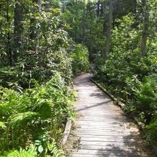
Scientists utilize this location for research on wetland ecosystems, examining the relationships between hydrophytic and xeric plant species.

Practical

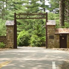
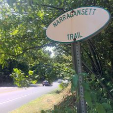
Access is via marked trails at 445 North Road with parking for a small number of vehicles. The ground can be muddy, so appropriate footwear and care on the paths are advisable.

Did you know?

The site displays vegetation zones representing different stages of ecological succession, showing how wetlands naturally develop from water to dry land. Researchers use these natural changes as a living laboratory for wetland ecology.

Location
GPS coordinates
41.50530,-71.78290
Latest update
December 9, 2025 12:26

AroundUs brings together thousands of curated places, local tips, and hidden gems, enriched daily by 60,000 contributors worldwide. Discover all places nearby (Rhode Island).

Around this place
Yawgoog Scout Reservation
United States of America

Yawgoog Scout Reservation

1.8 km
Pachaug State Forest
United States of America

Pachaug State Forest

13.1 km
Wilcox Park
United States of America

Wilcox Park

14.7 km
Narragansett Trail
United States of America

Narragansett Trail

14.3 km
Tomaquag Rock Shelters
United States of America

Tomaquag Rock Shelters

7.4 km
Shannock Historic District
United States of America

Shannock Historic District

13.4 km
Kinne Cemetery
United States of America

Kinne Cemetery

10.4 km
Westerly Downtown Historic District
United States of America

Westerly Downtown Historic District

14.8 km
Albert S. Potter Octagon House
United States of America

Albert S. Potter Octagon House

11.1 km
John Randall House
United States of America

John Randall House

11.8 km
Hopkinton City Historic District
United States of America

Hopkinton City Historic District

4.9 km
Usquepaug Road Historic District
United States of America

Usquepaug Road Historic District

15.2 km
North Stonington Village Historic District
United States of America

North Stonington Village Historic District

11 km
Westerly Armory
United States of America

Westerly Armory

14.2 km
Main Street Historic District
United States of America

Main Street Historic District

15.2 km
Austin Farm Road Agricultural Area
United States of America

Austin Farm Road Agricultural Area

14.1 km
North End Historic District
United States of America

North End Historic District

13.6 km
Joseph Jeffrey House
United States of America

Joseph Jeffrey House

12.9 km
Samuel Miner House
United States of America

Samuel Miner House

10.9 km
John Hoxsie House
United States of America

John Hoxsie House

11.8 km
Wylie School
United States of America

Wylie School

12.7 km
Edward Cogswell House
United States of America

Edward Cogswell House

13.3 km
Hillsdale Historic and Archeological District
United States of America

Hillsdale Historic and Archeological District

12 km
Tomaquag Indian Museum
United States of America

Tomaquag Indian Museum

9.1 km
Bradford Village Historic District
United States of America

Bradford Village Historic District

11.8 km
Hope Valley Historic District
United States of America

Hope Valley Historic District

5.5 km
Browning Mill Pond Area Beach
United States of America

Browning Mill Pond Area Beach

9.6 km
White Rock Bridge
United States of America

White Rock Bridge

13 km
Show the full map
« Ell Pond - National Natural Landmark in Hopkinton, Rhode Island » is provided by Around Us (aroundus.com). Images and texts are derived from Wikimedia project under a Creative Commons license. You are allowed to copy, distribute, and modify copies of this page, under the conditions set by the license, as long as this note is clearly visible.

Discover hidden gems everywhere you go!

From secret cafés to breathtaking viewpoints, skip the crowded tourist spots and find places that match your style. Our app makes it easy with voice search, smart filtering, route optimization, and insider tips from travelers worldwide. Download now for the complete mobile experience.

Around Us App Screenshot

A unique approach to discovering new places

Le Figaro

All the places worth exploring

France Info

A tailor-made excursion in just a few clicks

20 Minutes

Around Us
Travel Guide & Maps
Download

Send to your phone

QR Code
1

Open the camera app on your mobile.

2

Point at the QR code with your camera. A notification will appear.

3

Tap the notification to open the link.