Enable Location

We need your location to show you interesting places around you

Discover nearby places

Find interesting locations and hidden gems around you

Precise directions

Get accurate directions and distances to places

Your location is never shared with other users. It's only used when you tap the location button.

Kinne Cemetery

Log in to your account

Start exploring — it's free

Trusted by 62,566 travelers worldwide

Continue with Google
Continue with Apple
or

We will send you a code to connect

By continuing, you accept our Terms and Conditions and our Privacy Policy

Check your inbox

We've sent a pincode in your inbox. Please enter the code below.

Kinne Cemetery, cemetery in New London County, Connecticut, United States

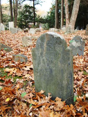
Kinne Cemetery is a small burial ground on a hillside in eastern Griswold, Connecticut, with graves spanning more than three hundred years. The headstones are made of natural stone such as gneiss, sandstone, or slate, ranging from simple unmarked rocks to elaborately carved stones featuring engraved symbols like angels and willow trees that evolved over the centuries.

The cemetery was established over three hundred years ago, with the oldest known grave dating to 1713 and belonging to the Kinne family who settled from Salem, Massachusetts. Over time, numerous Kinne descendants were buried here, including individuals who served in colonial wars and the American Revolution, continuing in use until the early twentieth century.

The cemetery bears the name of the Kinne family, early settlers who were buried here across many generations. Visitors can observe how the gravestones preserve memories of local families through their inscriptions and carved symbols, reflecting how this small community honored and remembered its members.

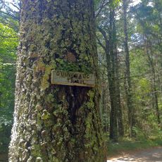
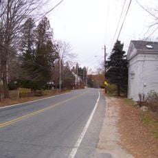
The cemetery is accessible from a quiet road with a small parking area near the entrance, from which a gravel path leads to the graves. The site is best explored on foot, and visitors should allow time to read the headstones and enjoy the peaceful surroundings bordered by trees and open fields.

The site contains approximately 80 unmarked stones of simple rounded shape that may represent original grave markers or have lost their inscriptions to weathering over time. These mysterious markers reveal early burial practices in a period before skilled carvers established their craft in the region.

The community of curious travelers

AroundUs brings together thousands of curated places, local tips, and hidden gems, enriched daily by 60,000 contributors worldwide.

Start exploring
Location
Inception
1713
GPS coordinates
41.55667,-71.88750
Latest update
February 9, 2026 08:19
Around this place
Yawgoog Scout Reservation
United States of America

Yawgoog Scout Reservation

10 km
Pachaug State Forest
United States of America

Pachaug State Forest

4.8 km
Mashantucket Pequot Museum and Research Center
United States of America

Mashantucket Pequot Museum and Research Center

11.9 km
Narragansett Trail
United States of America

Narragansett Trail

11.7 km
Hopeville Pond State Park
United States of America

Hopeville Pond State Park

6.2 km
Ell Pond
United States of America

Ell Pond

10.4 km
Butts Bridge
United States of America

Butts Bridge

12.6 km
Ashland Mill Bridge
United States of America

Ashland Mill Bridge

9.3 km
Quinebaug Trail
United States of America

Quinebaug Trail

11.4 km
Anshei Israel Synagogue
United States of America

Anshei Israel Synagogue

10.8 km
Avery House
United States of America

Avery House

6.1 km
Hopkinton City Historic District
United States of America

Hopkinton City Historic District

14 km
North Stonington Village Historic District
United States of America

North Stonington Village Historic District

12.9 km
Andrew Clark House
United States of America

Andrew Clark House

11 km
Slater Library and Fanning Annex
United States of America

Slater Library and Fanning Annex

9.9 km
Long Society Meetinghouse
United States of America

Long Society Meetinghouse

12.6 km
Capt. John Clark House
United States of America

Capt. John Clark House

13.8 km
Packerville Bridge
United States of America

Packerville Bridge

13.3 km
Hallville Mill Historic District
United States of America

Hallville Mill Historic District

14 km
Timothy Lester Farmstead
United States of America

Timothy Lester Farmstead

6.1 km
Lawton Mills Historic District
United States of America

Lawton Mills Historic District

13.5 km
John Wilson House
United States of America

John Wilson House

9.5 km
Lathrop-Mathewson-Ross House
United States of America

Lathrop-Mathewson-Ross House

11.3 km
Mill Brook Bridge
United States of America

Mill Brook Bridge

12.7 km
Samuel Miner House
United States of America

Samuel Miner House

12 km
Wylie School
United States of America

Wylie School

6.9 km
Edward Cogswell House
United States of America

Edward Cogswell House

3.4 km
Stepstone Falls
United States of America

Stepstone Falls

12.3 km
Show the full map
« Kinne Cemetery - cemetery in New London County, Connecticut, United States » is provided by Around Us (aroundus.com). Images and texts are derived from Wikimedia project under a Creative Commons license. You are allowed to copy, distribute, and modify copies of this page, under the conditions set by the license, as long as this note is clearly visible.

Discover hidden gems everywhere you go!

From secret cafés to breathtaking viewpoints, skip the crowded tourist spots and find places that match your style. Our app makes it easy with voice search, smart filtering, route optimization, and insider tips from travelers worldwide. Download now for the complete mobile experience.

Around Us App Screenshot

A unique approach to discovering new places

Le Figaro

All the places worth exploring

France Info

A tailor-made excursion in just a few clicks

20 Minutes

Around Us
Travel Guide & Maps
Download

Send to your phone

QR Code
1

Open the camera app on your mobile.

2

Point at the QR code with your camera. A notification will appear.

3

Tap the notification to open the link.