Quinebaug Trail

Log in to your account

AroundUs is a community-driven map of interesting places, built by curious explorers like you. It grows with every review, story, and photo you share.
Connect to save your favorite spots, contribute locations, and create personalized routes.
Continue with Google
Continue with Apple
Continue with X
Continue with Facebook
Continue with email
By continuing, you accept our Terms and Conditions and our Privacy Policy
Create an account
Add to collection
Map
Suggest a change
Share

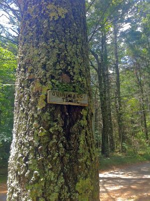
Quinebaug Trail, Nature trail in Connecticut, US.

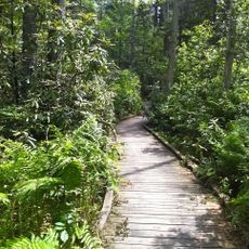
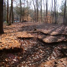
Quinebaug Trail is a hiking path spanning roughly 6.5 miles through Pachaug State Forest with rolling terrain and pine forest routes. The network provides overnight shelter options at multiple points and connects to adjacent trail systems for longer routes.

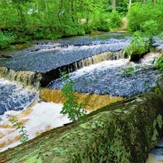
The trail follows sections near the Quinebaug River, which early Connecticut settlers used as a transportation route during colonial times. The modern protected forest and trail network developed much later as the area was preserved for public recreation.

The trail brings together hikers, runners, and seasonal visitors who explore the forest on foot or with snowshoes, creating a shared experience across different outdoor recreation communities.

Access to the trail is possible at several entry points, with parking available near the main access areas. Overnight shelter options operate on a first-come basis, so arriving early helps secure a spot if you plan to stay overnight.

An unmarked side path leads to Devil's Den rock formation, a hidden feature many visitors miss. The trail network also connects to the Pachaug, Nehantic, and Narragansett Trails, allowing hikers to extend their journey across a much larger area.

Location: Connecticut

GPS coordinates: 41.65860,-71.87200

Latest update: December 14, 2025 16:44

Photos
Around this place
United States of America

Canterbury Female Boarding School

9.4 km
Pachaug State Forest
United States of America

Pachaug State Forest

6.6 km
Hopeville Pond State Park
United States of America

Hopeville Pond State Park

6.9 km
Moosup Valley State Park Trail
United States of America

Moosup Valley State Park Trail

5.2 km
Central Village Historic District
United States of America

Central Village Historic District

7.2 km
Prudence Crandall House
United States of America

Prudence Crandall House

9.4 km
Butts Bridge
United States of America

Butts Bridge

8.3 km
Ashland Mill Bridge
United States of America

Ashland Mill Bridge

10.6 km
Rice City Historic District
United States of America

Rice City Historic District

10.6 km
Sterling Hill Historic District
United States of America

Sterling Hill Historic District

4 km
Avery House
United States of America

Avery House

6.6 km
Glen Falls Bridge
United States of America

Glen Falls Bridge

6.6 km
Slater Library and Fanning Annex
United States of America

Slater Library and Fanning Annex

10.9 km
Canterbury Center Historic District
United States of America

Canterbury Center Historic District

9.7 km
Capt. John Clark House
United States of America

Capt. John Clark House

8.5 km
Packerville Bridge
United States of America

Packerville Bridge

6.5 km
Lawton Mills Historic District
United States of America

Lawton Mills Historic District

4.4 km
John Wilson House
United States of America

John Wilson House

10.8 km
Lathrop-Mathewson-Ross House
United States of America

Lathrop-Mathewson-Ross House

10.7 km
Aldrich Free Public Library
United States of America

Aldrich Free Public Library

6.7 km
Mill Ridge Manor
United States of America

Mill Ridge Manor

7.3 km
Edward Cogswell House
United States of America

Edward Cogswell House

8.5 km
Plainfield Woolen Company Mill
United States of America

Plainfield Woolen Company Mill

7.4 km
Plainfield Street Historic District
United States of America

Plainfield Street Historic District

4.7 km
Capt. George Dorrance House
United States of America

Capt. George Dorrance House

11.5 km
Quinebaug River Prehistoric Archeological District
United States of America

Quinebaug River Prehistoric Archeological District

7.3 km
Wauregan Historic District
United States of America

Wauregan Historic District

10.3 km
Stepstone Falls
United States of America

Stepstone Falls

10.6 km
Show the full map
Reviews

Visited this place? Tap the stars to rate it and share your experience / photos with the community! Try now! You can cancel it anytime.

« Quinebaug Trail - Nature trail in Connecticut, US » is provided by Around Us (aroundus.com). Images and texts are derived from Wikimedia project under a Creative Commons license. You are allowed to copy, distribute, and modify copies of this page, under the conditions set by the license, as long as this note is clearly visible.

Discover hidden gems everywhere you go!

From secret cafés to breathtaking viewpoints, skip the crowded tourist spots and find places that match your style. Our app makes it easy with voice search, smart filtering, route optimization, and insider tips from travelers worldwide. Download now for the complete mobile experience.

Around Us App Screenshot

A unique approach to discovering new places

Le Figaro

All the places worth exploring

France Info

A tailor-made excursion in just a few clicks

20 Minutes