Moosup Valley State Park Trail

Log in to your account

AroundUs is a community-driven map of interesting places, built by curious explorers like you. It grows with every review, story, and photo you share.
Connect to save your favorite spots, contribute locations, and create personalized routes.
Continue with Google
Continue with Apple
Continue with X
Continue with Facebook
Continue with email
By continuing, you accept our Terms and Conditions and our Privacy Policy
Create an account
Add to collection
Map
Suggest a change
Share

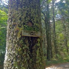
Moosup Valley State Park Trail, Rail trail in Windham County, Connecticut, United States.

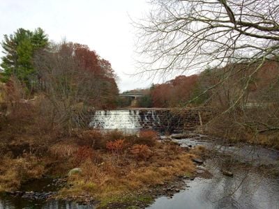
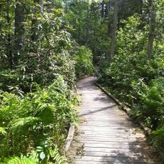
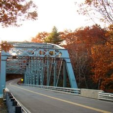
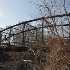
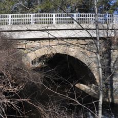
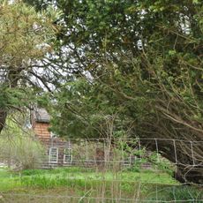
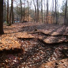
The Moosup Valley State Park Trail is a converted railroad corridor running through woodland areas with river crossings. The path features a mix of dirt, grass, and gravel surfaces, with two restored trestle bridges spanning the Moosup River along its length.

The trail follows a former railroad corridor that ceased operations in the late 1960s and remained unused for years. It was later developed into a public recreation area, opening to visitors in the following decade.

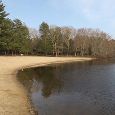
The trail serves as a local recreation route where neighbors walk, run, and cycle throughout the seasons. It connects rural settlements and provides a shared outdoor space where people from surrounding communities meet and enjoy the landscape.

Multiple access points with parking are distributed along the trail, allowing visitors to start from various locations. The path accommodates both casual walkers and experienced cyclists, though surface conditions may vary depending on weather and recent maintenance.

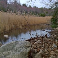
The trail surface combines an unusual mix of dirt, grass, sand, and old railroad stone all in one path. This varied terrain reflects the historical use of the corridor and creates a distinctive walking and cycling experience that changes beneath your feet.

Location: Connecticut

Inception: 1987

Website: https://portal.ct.gov/DEEP/State-Parks/Parks/Moosup-Valley-State-Park-Trail

GPS coordinates: 41.70000,-71.90000

Latest update: December 14, 2025 11:02

Photos
Around this place
United States of America

Canterbury Female Boarding School

6 km
Pachaug State Forest
United States of America

Pachaug State Forest

11.4 km
Hopeville Pond State Park
United States of America

Hopeville Pond State Park

10.4 km
United States of America

Israel Putnam Monument

10.5 km
Old Furnace State Park
United States of America

Old Furnace State Park

9.5 km
Central Village Historic District
United States of America

Central Village Historic District

2.1 km
Prudence Crandall House
United States of America

Prudence Crandall House

6 km
Butts Bridge
United States of America

Butts Bridge

8 km
Quinebaug Trail
United States of America

Quinebaug Trail

5.2 km
Rice City Historic District
United States of America

Rice City Historic District

11.3 km
Sterling Hill Historic District
United States of America

Sterling Hill Historic District

4.4 km
Avery House
United States of America

Avery House

10.3 km
Quinebaug Mill – Quebec Square Historic District
United States of America

Quinebaug Mill – Quebec Square Historic District

11 km
Brooklyn Green Historic District
United States of America

Brooklyn Green Historic District

10.6 km
Glen Falls Bridge
United States of America

Glen Falls Bridge

3.7 km
Jonathan Wheeler House
United States of America

Jonathan Wheeler House

9.4 km
Canterbury Center Historic District
United States of America

Canterbury Center Historic District

6.1 km
Capt. John Clark House
United States of America

Capt. John Clark House

7.4 km
Packerville Bridge
United States of America

Packerville Bridge

5.5 km
Lawton Mills Historic District
United States of America

Lawton Mills Historic District

3.2 km
Lathrop-Mathewson-Ross House
United States of America

Lathrop-Mathewson-Ross House

11.5 km
Aldrich Free Public Library
United States of America

Aldrich Free Public Library

2.9 km
Mill Ridge Manor
United States of America

Mill Ridge Manor

2.3 km
Plainfield Woolen Company Mill
United States of America

Plainfield Woolen Company Mill

2.3 km
Plainfield Street Historic District
United States of America

Plainfield Street Historic District

2 km
Capt. George Dorrance House
United States of America

Capt. George Dorrance House

10.4 km
Quinebaug River Prehistoric Archeological District
United States of America

Quinebaug River Prehistoric Archeological District

5.6 km
Wauregan Historic District
United States of America

Wauregan Historic District

5.2 km
Show the full map
Reviews

Visited this place? Tap the stars to rate it and share your experience / photos with the community! Try now! You can cancel it anytime.

« Moosup Valley State Park Trail - Rail trail in Windham County, Connecticut, United States » is provided by Around Us (aroundus.com). Images and texts are derived from Wikimedia project under a Creative Commons license. You are allowed to copy, distribute, and modify copies of this page, under the conditions set by the license, as long as this note is clearly visible.

Discover hidden gems everywhere you go!

From secret cafés to breathtaking viewpoints, skip the crowded tourist spots and find places that match your style. Our app makes it easy with voice search, smart filtering, route optimization, and insider tips from travelers worldwide. Download now for the complete mobile experience.

Around Us App Screenshot

A unique approach to discovering new places

Le Figaro

All the places worth exploring

France Info

A tailor-made excursion in just a few clicks

20 Minutes