Butts Bridge

Log in to your account

AroundUs is a community-driven map of interesting places, built by curious explorers like you. It grows with every review, story, and photo you share.
Connect to save your favorite spots, contribute locations, and create personalized routes.
Continue with Google
Continue with Apple
Continue with X
Continue with Facebook
Continue with email
By continuing, you accept our Terms and Conditions and our Privacy Policy
Create an account
Add to collection
Map
Suggest a change
Share

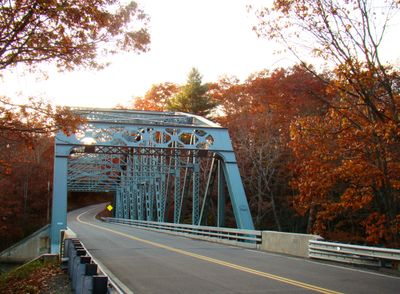
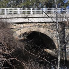
Butts Bridge, Steel road bridge in Canterbury, Connecticut.

Butts Bridge is a steel road crossing over the Quinebaug River in Canterbury built with a Parker truss design. It spans approximately 231 feet (70 meters) with a 31-foot (9-meter) wide roadway supported by concrete foundations.

It was built in 1936 by Fort Pitt Bridge Works in response to severe flooding that damaged earlier structures at this crossing. The construction marked the shift to modern steel engineering for regional infrastructure.

This structure shows how communities adapted to automobile traffic in the early 20th century and modernized their crossing points. It reflects the shift from traditional river crossing methods to engineered road infrastructure.

The bridge connects Norwich and Plainfield along a regional road and accommodates regular vehicle traffic between these communities. Pedestrians can cross here to travel between the two towns, especially when traffic is lighter.

Older bridge abutments remain visible upstream, leaving physical traces of earlier construction methods at this river crossing. These remnants allow visitors to compare different engineering approaches from different time periods.

Location: Connecticut

GPS coordinates: 41.65139,-71.97083

Latest update: December 14, 2025 14:44

Photos
Around this place
United States of America

Canterbury Female Boarding School

5.2 km
Pachaug State Forest
United States of America

Pachaug State Forest

9.7 km
Hopeville Pond State Park
United States of America

Hopeville Pond State Park

6.5 km
Moosup Valley State Park Trail
United States of America

Moosup Valley State Park Trail

8 km
Ashlawn
United States of America

Ashlawn

6.3 km
Salt Rock State Campground
United States of America

Salt Rock State Campground

10.3 km
Central Village Historic District
United States of America

Central Village Historic District

9.2 km
Prudence Crandall House
United States of America

Prudence Crandall House

5.2 km
Ashland Mill Bridge
United States of America

Ashland Mill Bridge

5.1 km
Quinebaug Trail
United States of America

Quinebaug Trail

8.3 km
Samuel Huntington Birthplace
United States of America

Samuel Huntington Birthplace

10.9 km
Anshei Israel Synagogue
United States of America

Anshei Israel Synagogue

5.8 km
Avery House
United States of America

Avery House

6.8 km
Andrew Clark House
United States of America

Andrew Clark House

5.2 km
Slater Library and Fanning Annex
United States of America

Slater Library and Fanning Annex

4.9 km
Canterbury Center Historic District
United States of America

Canterbury Center Historic District

5.6 km
Capt. John Clark House
United States of America

Capt. John Clark House

1.3 km
Packerville Bridge
United States of America

Packerville Bridge

2.5 km
William Park House
United States of America

William Park House

7.9 km
Timothy Lester Farmstead
United States of America

Timothy Lester Farmstead

9.4 km
Lawton Mills Historic District
United States of America

Lawton Mills Historic District

5 km
John Wilson House
United States of America

John Wilson House

5.1 km
Lathrop-Mathewson-Ross House
United States of America

Lathrop-Mathewson-Ross House

3.7 km
Mill Ridge Manor
United States of America

Mill Ridge Manor

9.4 km
Edward Cogswell House
United States of America

Edward Cogswell House

9.3 km
Plainfield Woolen Company Mill
United States of America

Plainfield Woolen Company Mill

9.3 km
Plainfield Street Historic District
United States of America

Plainfield Street Historic District

6 km
Quinebaug River Prehistoric Archeological District
United States of America

Quinebaug River Prehistoric Archeological District

2.7 km
Show the full map
Reviews

Visited this place? Tap the stars to rate it and share your experience / photos with the community! Try now! You can cancel it anytime.

« Butts Bridge - Steel road bridge in Canterbury, Connecticut » is provided by Around Us (aroundus.com). Images and texts are derived from Wikimedia project under a Creative Commons license. You are allowed to copy, distribute, and modify copies of this page, under the conditions set by the license, as long as this note is clearly visible.

Discover hidden gems everywhere you go!

From secret cafés to breathtaking viewpoints, skip the crowded tourist spots and find places that match your style. Our app makes it easy with voice search, smart filtering, route optimization, and insider tips from travelers worldwide. Download now for the complete mobile experience.

Around Us App Screenshot

A unique approach to discovering new places

Le Figaro

All the places worth exploring

France Info

A tailor-made excursion in just a few clicks

20 Minutes