Ashland Mill Bridge

Log in to your account

AroundUs is a community-driven map of interesting places, built by curious explorers like you. It grows with every review, story, and photo you share.
Connect to save your favorite spots, contribute locations, and create personalized routes.
Continue with Google
Continue with Apple
Continue with X
Continue with Facebook
Continue with email
By continuing, you accept our Terms and Conditions and our Privacy Policy
Create an account
Add to collection
Map
Suggest a change
Share

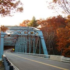
Ashland Mill Bridge, Iron truss bridge in Griswold, Connecticut.

Ashland Mill Bridge is an iron truss bridge in Griswold, Connecticut, that once crossed the Pachaug River. The structure featured a lenticular design with curved upper members and wrought iron components.

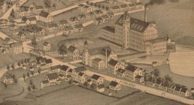
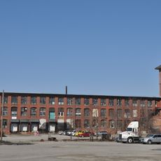
The bridge was constructed in 1886 by the Berlin Iron Bridge Company following a dam failure that created the need for a new crossing. It connected Ashland Street to the Ashland Cotton Company millyard.

The bridge demonstrates late 19th-century engineering craftsmanship and the shift from wooden to metal structures in New England manufacturing areas. It reflects how local industries adopted new construction techniques to support their operations.

Visitors should know the bridge was deemed unsafe in 1999 and relocated to a parking lot for preservation. Access to the structure may be limited, so checking local information about viewing the bridge is advisable.

The bridge crossed the river at an unusual 28-degree angle rather than perpendicular, an adaptation to the site's specific conditions. This angled design is an often-overlooked detail that makes the structure technically distinctive.

Location: Connecticut

GPS coordinates: 41.60553,-71.97808

Latest update: December 14, 2025 14:41

Photos
Around this place
United States of America

Canterbury Female Boarding School

10.3 km
Pachaug State Forest
United States of America

Pachaug State Forest

8.4 km
Hopeville Pond State Park
United States of America

Hopeville Pond State Park

4.9 km
Ashlawn
United States of America

Ashlawn

5.9 km
Salt Rock State Campground
United States of America

Salt Rock State Campground

10.2 km
Prudence Crandall House
United States of America

Prudence Crandall House

10.3 km
Butts Bridge
United States of America

Butts Bridge

5.1 km
Quinebaug Trail
United States of America

Quinebaug Trail

10.6 km
Mohegan State Forest
United States of America

Mohegan State Forest

11 km
United States of America

Greeneville

10.3 km
Anshei Israel Synagogue
United States of America

Anshei Israel Synagogue

1.9 km
Avery House
United States of America

Avery House

5.3 km
Andrew Clark House
United States of America

Andrew Clark House

1.8 km
Slater Library and Fanning Annex
United States of America

Slater Library and Fanning Annex

595 m
Long Society Meetinghouse
United States of America

Long Society Meetinghouse

9.3 km
Canterbury Center Historic District
United States of America

Canterbury Center Historic District

10.7 km
Capt. John Clark House
United States of America

Capt. John Clark House

6.4 km
Packerville Bridge
United States of America

Packerville Bridge

7.3 km
Timothy Lester Farmstead
United States of America

Timothy Lester Farmstead

4.5 km
Lawton Mills Historic District
United States of America

Lawton Mills Historic District

9.2 km
William Park House
United States of America

William Park House

8.5 km
John Wilson House
United States of America

John Wilson House

209 m
Lathrop-Mathewson-Ross House
United States of America

Lathrop-Mathewson-Ross House

2.1 km
Mill Brook Bridge
United States of America

Mill Brook Bridge

7.4 km
Edward Cogswell House
United States of America

Edward Cogswell House

6.7 km
Col. Joshua Huntington House
United States of America

Col. Joshua Huntington House

11.2 km
Plainfield Street Historic District
United States of America

Plainfield Street Historic District

10.4 km
Quinebaug River Prehistoric Archeological District
United States of America

Quinebaug River Prehistoric Archeological District

7.7 km
Show the full map
Reviews

Visited this place? Tap the stars to rate it and share your experience / photos with the community! Try now! You can cancel it anytime.

« Ashland Mill Bridge - Iron truss bridge in Griswold, Connecticut » is provided by Around Us (aroundus.com). Images and texts are derived from Wikimedia project under a Creative Commons license. You are allowed to copy, distribute, and modify copies of this page, under the conditions set by the license, as long as this note is clearly visible.

Discover hidden gems everywhere you go!

From secret cafés to breathtaking viewpoints, skip the crowded tourist spots and find places that match your style. Our app makes it easy with voice search, smart filtering, route optimization, and insider tips from travelers worldwide. Download now for the complete mobile experience.

Around Us App Screenshot

A unique approach to discovering new places

Le Figaro

All the places worth exploring

France Info

A tailor-made excursion in just a few clicks

20 Minutes