Enable Location

We need your location to show you interesting places around you

Discover nearby places

Find interesting locations and hidden gems around you

Precise directions

Get accurate directions and distances to places

Your location is never shared with other users. It's only used when you tap the location button.

Hopeville Pond State Park

Log in to your account

Start exploring — it's free

Trusted by 62,568 travelers worldwide

Continue with Google
Continue with Apple
or

We will send you a code to connect

By continuing, you accept our Terms and Conditions and our Privacy Policy

Check your inbox

We've sent a pincode in your inbox. Please enter the code below.

Hopeville Pond State Park

Hopeville Pond State Park, State park with pond in Griswold, Connecticut, US

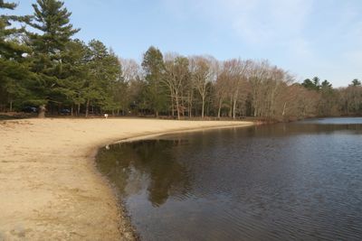
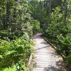
Hopeville Pond State Park is a state park in Griswold, Connecticut, centered on a freshwater reservoir created by damming the Pachaug River. The park contains more than 80 wooded camping sites and provides access to boating and fishing on the water.

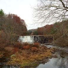
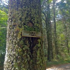
The area was once a major fishing ground for the Mohegan people and later became home to a woolen mill operation. The state park was established in 1938 to protect the land and its layered past.

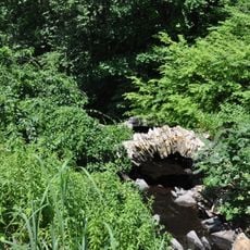
Stone weirs built by the Mohegan people appear when water levels drop, showing how they fished in this waterway. These old structures still mark the river today and tell of generations who lived along this land.

The park can be accessed during different seasons and offers camping, boating, and fishing for visitors of varying experience levels. Before visiting, check on accessibility of specific areas and the best times to find what you are looking for.

Paddlers can explore the larger Pachaug Pond waterway system by portaging their boats around the dam. This connection to a more extensive water network makes the location especially interesting for longer paddling adventures.

The community of curious travelers

AroundUs brings together thousands of curated places, local tips, and hidden gems, enriched daily by 60,000 contributors worldwide.

Start exploring
Location
Inception
1938
Elevation above the sea
71 m
GPS coordinates
41.60750,-71.91889
Latest update
December 12, 2025 12:07
Around this place
United States of America

Canterbury Female Boarding School

11 km
Pachaug State Forest
United States of America

Pachaug State Forest

3.5 km
Moosup Valley State Park Trail
United States of America

Moosup Valley State Park Trail

10.4 km
Ashlawn
United States of America

Ashlawn

10.5 km
Central Village Historic District
United States of America

Central Village Historic District

12.4 km
Prudence Crandall House
United States of America

Prudence Crandall House

11 km
Kinne Cemetery
United States of America

Kinne Cemetery

6.2 km
Butts Bridge
United States of America

Butts Bridge

6.5 km
Ashland Mill Bridge
United States of America

Ashland Mill Bridge

4.9 km
Quinebaug Trail
United States of America

Quinebaug Trail

6.9 km
Sterling Hill Historic District
United States of America

Sterling Hill Historic District

10.8 km
Anshei Israel Synagogue
United States of America

Anshei Israel Synagogue

6.8 km
Avery House
United States of America

Avery House

417 m
Andrew Clark House
United States of America

Andrew Clark House

6.7 km
Slater Library and Fanning Annex
United States of America

Slater Library and Fanning Annex

5.4 km
Long Society Meetinghouse
United States of America

Long Society Meetinghouse

12.7 km
Canterbury Center Historic District
United States of America

Canterbury Center Historic District

11.4 km
Capt. John Clark House
United States of America

Capt. John Clark House

7.7 km
Packerville Bridge
United States of America

Packerville Bridge

7.1 km
Timothy Lester Farmstead
United States of America

Timothy Lester Farmstead

5.6 km
Lawton Mills Historic District
United States of America

Lawton Mills Historic District

7.6 km
John Wilson House
United States of America

John Wilson House

5.1 km
Lathrop-Mathewson-Ross House
United States of America

Lathrop-Mathewson-Ross House

6.2 km
Mill Brook Bridge
United States of America

Mill Brook Bridge

11.5 km
Wylie School
United States of America

Wylie School

6.2 km
Mill Ridge Manor
United States of America

Mill Ridge Manor

12.6 km
Edward Cogswell House
United States of America

Edward Cogswell House

2.8 km
Plainfield Street Historic District
United States of America

Plainfield Street Historic District

8.7 km
Show the full map
« Hopeville Pond State Park - State park with pond in Griswold, Connecticut, US » is provided by Around Us (aroundus.com). Images and texts are derived from Wikimedia project under a Creative Commons license. You are allowed to copy, distribute, and modify copies of this page, under the conditions set by the license, as long as this note is clearly visible.

Discover hidden gems everywhere you go!

From secret cafés to breathtaking viewpoints, skip the crowded tourist spots and find places that match your style. Our app makes it easy with voice search, smart filtering, route optimization, and insider tips from travelers worldwide. Download now for the complete mobile experience.

Around Us App Screenshot

A unique approach to discovering new places

Le Figaro

All the places worth exploring

France Info

A tailor-made excursion in just a few clicks

20 Minutes

Around Us
Travel Guide & Maps
Download

Send to your phone

QR Code
1

Open the camera app on your mobile.

2

Point at the QR code with your camera. A notification will appear.

3

Tap the notification to open the link.