Eliot Burying Ground

Log in to your account

AroundUs is a community-driven map of interesting places, built by curious explorers like you. It grows with every review, story, and photo you share.
Connect to save your favorite spots, contribute locations, and create personalized routes.
Continue with Google
Continue with Apple
Continue with X
Continue with Facebook
Continue with email
By continuing, you accept our Terms and Conditions and our Privacy Policy
Create an account
Add to collection
Map
Suggest a change
Share

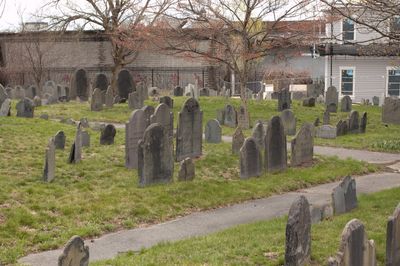
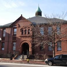
Eliot Burying Ground, Historic cemetery in Roxbury, Boston, United States.

Eliot Burying Ground is a 0.8-acre cemetery at the intersection of Eustis and Washington Streets, featuring stone walls and traditional grave markers from the colonial period. The site contains the Minister's Tomb with the remains of John Eliot and five other clergy members, as well as the Dudley family tomb holding several colonial-era governors.

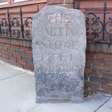
Established in 1630 as Roxbury's first burial ground, this cemetery served the community for over 350 years. During the 1775 siege of Boston, American colonists built a redoubt on the site, connecting the location to the fight for independence.

The burial ground is named after John Eliot, the minister who led the First Church of Roxbury. Visitors can see through the grave markers how clergy and prominent families shaped the religious and social order during the early colonial period.

Visiting the cemetery requires advance registration with the Boston Parks and Recreation Department, which offers guided tours and research access. The best time to visit is during daylight hours when the weather is clear, since the site is outdoors and some areas may be difficult to access in poor conditions.

During the siege of Boston, the cemetery served as a strategic military site where American forces built a redoubt to defend the city. This overlap of civilian burial and military use makes it a rare example of a place that functioned as both cemetery and fortress at the same time.

Location: Boston

Inception: 1635

GPS coordinates: 42.33194,-71.08194

Latest update: December 14, 2025 09:41

Photos
Around this place
Matthews Arena
United States of America

Matthews Arena

1 km
Huntington Avenue Grounds
United States of America

Huntington Avenue Grounds

961 m
Roxbury Highlands Historic District
United States of America

Roxbury Highlands Historic District

1 km
Islamic Society of Boston
United States of America

Islamic Society of Boston

950 m
1767 Milestones
United States of America

1767 Milestones

807 m
United States of America

Hotel Alexandra

634 m
Roxbury Heritage State Park
United States of America

Roxbury Heritage State Park

735 m
Lower Roxbury Historic District
United States of America

Lower Roxbury Historic District

629 m
St. Joseph Catholic Church
United States of America

St. Joseph Catholic Church

1 km
Hibernian Hall
United States of America

Hibernian Hall

374 m
Twelfth Baptist Church, Boston
United States of America

Twelfth Baptist Church, Boston

740 m
Edward Everett Hale House
United States of America

Edward Everett Hale House

933 m
Frederick Douglass Square Historic District
United States of America

Frederick Douglass Square Historic District

479 m
Alvah Kittredge House
United States of America

Alvah Kittredge House

1 km
John Eliot Square District
United States of America

John Eliot Square District

772 m
Tremont Street Methodist Episcopal Church
United States of America

Tremont Street Methodist Episcopal Church

944 m
Dudley Station Historic District
United States of America

Dudley Station Historic District

299 m
Mount Pleasant Historic District
United States of America

Mount Pleasant Historic District

733 m
Moreland Street Historic District
United States of America

Moreland Street Historic District

941 m
South End District
United States of America

South End District

1.1 km
Goldsmith Block
United States of America

Goldsmith Block

163 m
Frances and Isabella Apartments
United States of America

Frances and Isabella Apartments

1 km
Governor Shirley Square Historic District
United States of America

Governor Shirley Square Historic District

874 m
Greenville Street Historic District
United States of America

Greenville Street Historic District

473 m
Cy Young
United States of America

Cy Young

971 m
Joshua Bates School
United States of America

Joshua Bates School

1.1 km
Roxbury Parting Stone
United States of America

Roxbury Parting Stone

830 m
Church of the Immaculate Conception
United States of America

Church of the Immaculate Conception

901 m
Show the full map
Reviews

Visited this place? Tap the stars to rate it and share your experience / photos with the community! Try now! You can cancel it anytime.

« Eliot Burying Ground - Historic cemetery in Roxbury, Boston, United States » is provided by Around Us (aroundus.com). Images and texts are derived from Wikimedia project under a Creative Commons license. You are allowed to copy, distribute, and modify copies of this page, under the conditions set by the license, as long as this note is clearly visible.

Discover hidden gems everywhere you go!

From secret cafés to breathtaking viewpoints, skip the crowded tourist spots and find places that match your style. Our app makes it easy with voice search, smart filtering, route optimization, and insider tips from travelers worldwide. Download now for the complete mobile experience.

Around Us App Screenshot

A unique approach to discovering new places

Le Figaro

All the places worth exploring

France Info

A tailor-made excursion in just a few clicks

20 Minutes