Enable Location

We need your location to show you interesting places around you

Discover nearby places

Find interesting locations and hidden gems around you

Precise directions

Get accurate directions and distances to places

Your location is never shared with other users. It's only used when you tap the location button.

Etters Bridge

Log in to your account

Start exploring — it's free

Trusted by 60,654 travelers worldwide

Continue with Google
Continue with Apple
or

We will send you a code to connect

By continuing, you accept our Terms and Conditions and our Privacy Policy

Check your inbox

We've sent a pincode in your inbox. Please enter the code below.

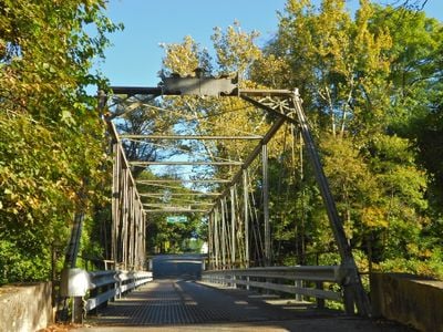
Etters Bridge, Historic Pratt truss bridge in Lower Allen Township, Pennsylvania, United States.

Description

Etters Bridge is a steel truss structure built in 1889 that crosses Yellow Breeches Creek and allows traffic and foot passage. The design uses a Pratt truss system, which distributes loads through angled and vertical supports typical of bridges from that period.

History

The bridge was built in 1889 by Dean & Westbrook using steel components supplied by the Phoenix Bridge Company, reflecting the industrial advancement of the late 1800s. It received National Register recognition in 1986 for its engineering importance and historical value to the region.

Culture

The bridge was built using construction methods typical of the late 1800s and remains a working part of the local community's daily life. Residents and visitors continue to cross it on foot or by vehicle, experiencing firsthand how people solved transportation challenges over a century ago.

Practical

The bridge is accessible from Green Lane Drive and remains in active use for both vehicle and foot traffic. Visitors should be aware that the structure is protected as a historic site and retains original design features that may limit modern modifications.

Did you know?

The bridge's steel components were manufactured by the Phoenix Bridge Company, a firm known for advanced construction methods in the 1800s. This manufacturing connection shows how specialized factories produced metal parts that were assembled on site into complete structures.

Location
GPS coordinates
40.22390,-76.89750
Latest update
December 14, 2025 18:05

AroundUs brings together thousands of curated places, local tips, and hidden gems, enriched daily by 60,000 contributors worldwide. Discover all places nearby (Pennsylvania).

Around this place
Pennsylvania State Capitol
United States of America

Pennsylvania State Capitol

4.7 km
City Island
United States of America

City Island

3.6 km
Walnut Street Bridge
United States of America

Walnut Street Bridge

3.9 km
Pennsylvania State Capitol Complex
United States of America

Pennsylvania State Capitol Complex

4.8 km
Philadelphia & Reading Railroad Bridge
United States of America

Philadelphia & Reading Railroad Bridge

3.1 km
Cumberland Valley Railroad Bridge
United States of America

Cumberland Valley Railroad Bridge

3.3 km
Whitaker Center for Science and the Arts
United States of America

Whitaker Center for Science and the Arts

4.3 km
United States of America

Commonwealth

4.7 km
Cathedral of Saint Patrick
United States of America

Cathedral of Saint Patrick

4.5 km
Simon Cameron House
United States of America

Simon Cameron House

4 km
Ronald Reagan Federal Building
United States of America

Ronald Reagan Federal Building

4.4 km
Market Street Bridge
United States of America

Market Street Bridge

3.8 km
St. Stephen's Episcopal Cathedral
United States of America

St. Stephen's Episcopal Cathedral

4.2 km
Dauphin County Courthouse
United States of America

Dauphin County Courthouse

4 km
Harris Switch Tower
United States of America

Harris Switch Tower

4.8 km
Mulberry Street Bridge
United States of America

Mulberry Street Bridge

4.6 km
Harrisburg Technical High School
United States of America

Harrisburg Technical High School

4.6 km
William Black Homestead
United States of America

William Black Homestead

1.1 km
John Wormley House
United States of America

John Wormley House

3.6 km
William R. Griffith House
United States of America

William R. Griffith House

4.2 km
Harrisburg Historic District
United States of America

Harrisburg Historic District

4.1 km
William Seel Building
United States of America

William Seel Building

4.4 km
State Museum of Pennsylvania
United States of America

State Museum of Pennsylvania

4.8 km
Holy Annunciation Macedonian Bulgarian Eastern Orthodox Church
Bulgaria

Holy Annunciation Macedonian Bulgarian Eastern Orthodox Church

4.4 km
M. Harvey Taylor Memorial Bridge
United States of America

M. Harvey Taylor Memorial Bridge

4.3 km
John Harris Bridge
United States of America

John Harris Bridge

3.2 km
Old Downtown Harrisburg Commercial Historic District
United States of America

Old Downtown Harrisburg Commercial Historic District

4.3 km
Kunkel Building
United States of America

Kunkel Building

4.3 km
Show the full map
« Etters Bridge - Historic Pratt truss bridge in Lower Allen Township, Pennsylvania, United States » is provided by Around Us (aroundus.com). Images and texts are derived from Wikimedia project under a Creative Commons license. You are allowed to copy, distribute, and modify copies of this page, under the conditions set by the license, as long as this note is clearly visible.

Discover hidden gems everywhere you go!

From secret cafés to breathtaking viewpoints, skip the crowded tourist spots and find places that match your style. Our app makes it easy with voice search, smart filtering, route optimization, and insider tips from travelers worldwide. Download now for the complete mobile experience.

Around Us App Screenshot

A unique approach to discovering new places

Le Figaro

All the places worth exploring

France Info

A tailor-made excursion in just a few clicks

20 Minutes

Around Us
Travel Guide & Maps
Download

Send to your phone

QR Code
1

Open the camera app on your mobile.

2

Point at the QR code with your camera. A notification will appear.

3

Tap the notification to open the link.