Seven Ranges Terminus
Seven Ranges Terminus, Surveying benchmark in Magnolia, United States.
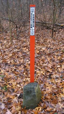
Seven Ranges Terminus is a surveying marker located in Magnolia where three counties meet. The granite stone with an inscribed X marks the starting point where land surveyors began measuring the territory.
The stone was placed on August 10, 1786, marking the start of surveying the Northwest Territory. This marker helped organize newly acquired lands for American settlement in the years that followed.
The rectangular survey system implemented at this location established methods for measuring and distributing land across the expanding United States territory.
The marker sits on private property, a short walk from the nearest public road. It's best to check access permission beforehand and wear sturdy shoes for the walk.
The granite has kept its original location despite past efforts to move it. Ground frost over the years has caused it to tip slightly to one side.
Location: Stark County
Location: Tuscarawas County
Location: Carroll County
Inception: August 10, 1786
GPS coordinates: 40.65194,-81.31806
Latest update: December 14, 2025 16:46
President William McKinley National Memorial
18.4 km
Atwood Lake
14.2 km
Clearview Golf Club
14.6 km
Fort Laurens
11.8 km
Central Catholic High School
18.6 km
Palace Theatre
17.4 km
Canton Museum of Art
17.9 km
Canton Public Library
16.9 km
Stark County Courthouse
17.1 km
St. Mary of the Immaculate Conception Church
6.7 km
Bender's Restaurant-Belmont Buffet
17 km
First Methodist Episcopal Church
17 km
First Church of the Resurrection
16.8 km
Harry E. Fife House
16.8 km
Upper Downtown Canton Historic District
17.1 km
Brooke and Anna E. Martin House
18.8 km
St. Paul's Reformed Church
18.8 km
Eagles Temple
16.6 km
Patrick Hull House
15.1 km
William McKinley Presidential Library and Museum
18.3 km
Fort Laurens Museum
11.7 km
Canton Classic Car Museum
16.7 km
Historic Zoar Village
9.9 km
Mohawk Theater
5.3 km
Elson-Magnolia Flour Mill
1.6 km
First Reformed and First Lutheran Churches
16.7 km
Clearview Golf Club, 1946
14.7 km
Zoarville Bridge
10.4 kmVisited this place? Tap the stars to rate it and share your experience / photos with the community! Try now! You can cancel it anytime.
Discover hidden gems everywhere you go!
From secret cafés to breathtaking viewpoints, skip the crowded tourist spots and find places that match your style. Our app makes it easy with voice search, smart filtering, route optimization, and insider tips from travelers worldwide. Download now for the complete mobile experience.
A unique approach to discovering new places❞
— Le Figaro
All the places worth exploring❞
— France Info
A tailor-made excursion in just a few clicks❞
— 20 Minutes