Chest opened
+${chestReward.xp} XP
Explorer
NOUVEAU ×${chestReward.collectible.quantity}
tapez pour fermer
Chest locked

Open chests in the app

Around Us is built for your phone — chests unlock when you walk, explore and capture nearby places.

Enable Location

We need your location to show you interesting places around you

Discover nearby places

Find interesting locations and hidden gems around you

Precise directions

Get accurate directions and distances to places

Your location is never shared with other users. It's only used when you tap the location button.

Interstate 495

Log in to your account

Start exploring — it's free

Trusted by 72,884 travelers worldwide

Continue with Google
Continue with Apple
or

We will send you a code to connect

By continuing, you accept our Terms and Conditions and our Privacy Policy

Check your inbox

We've sent a pincode in your inbox. Please enter the code below.

Interstate 495
Discussion Reviews 1 Photos
26.2k Popularity

Interstate 495, Highway ring road around Washington DC, United States

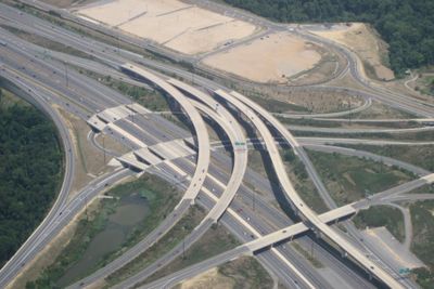
Interstate 495 is a ring road circling Washington D.C. through Virginia and Maryland, serving as the main route connecting suburban areas and communities around the nation's capital. The route passes through several counties and the city of Alexandria, handling traffic between different regions.

Construction of this highway link began in the early 1960s and was completed by the middle of the decade as part of the interstate expansion. The road transformed rural areas surrounding the nation's capital into suburban corridors.

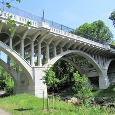
The road contains two significant river crossings: the Woodrow Wilson Memorial Bridge and American Legion Memorial Bridge, representing engineering achievements.

The road has eight lanes on most sections, with expansions to ten lanes at certain points to handle daily traffic volume. The ring also features two major river crossings that direct traffic across waterways connecting different areas.

An eastern section was later redesignated as part of a major interstate route after earlier plans for a direct passage through the city were abandoned. This rerouting reflected decisions made to protect the core of the nation's capital.

The community of curious travelers

AroundUs brings together thousands of curated places, local tips, and hidden gems, enriched daily by 60,000 contributors worldwide.

Start exploring
Location
Location
Location
Official opening
August 17, 1964
Part of
Interstate Highway System
GPS coordinates
39.01854,-76.96997
Latest update
December 20, 2025 15:30
Around this place
SECU Stadium
United States of America

SECU Stadium

3.7 km
General Conference of Seventh-day Adventists
United States of America

General Conference of Seventh-day Adventists

4.8 km
Jones-Hill House
United States of America

Jones-Hill House

4 km
United States National Agricultural Library
United States of America

United States National Agricultural Library

4.2 km
Clarice Smith Performing Arts Center
United States of America

Clarice Smith Performing Arts Center

3.5 km
Shipley Field
United States of America

Shipley Field

4 km
Adele H. Stamp Student Union
United States of America

Adele H. Stamp Student Union

4 km
The Rossborough Inn
United States of America

The Rossborough Inn

4.6 km
Rachel Carson House
United States of America

Rachel Carson House

4.1 km
Polychrome Historic District
United States of America

Polychrome Historic District

3.9 km
University of Maryland Art Gallery
United States of America

University of Maryland Art Gallery

4.2 km
United States of America

National Archives archeological site

2.2 km
Adelphi Mill
United States of America

Adelphi Mill

2.9 km
Robert E. Taylor Stadium
United States of America

Robert E. Taylor Stadium

3.1 km
University of Maryland Arboretum & Botanical Garden
United States of America

University of Maryland Arboretum & Botanical Garden

4.7 km
Bowlero College Park
United States of America

Bowlero College Park

4 km
Library of American Broadcasting
United States of America

Library of American Broadcasting

4.2 km
Ash Hill
United States of America

Ash Hill

4.4 km
Davis-Warner House
United States of America

Davis-Warner House

3.7 km
Martin Luther King Jr. Park
United States of America

Martin Luther King Jr. Park

4.3 km
Carroll Avenue Bridge
United States of America

Carroll Avenue Bridge

4.7 km
Tydings Hall
United States of America

Tydings Hall

4.4 km
Langley Park
United States of America

Langley Park

2.9 km
Stadium Drive Garage
United States of America

Stadium Drive Garage

3.6 km
Northwest Branch Recreational Park
United States of America

Northwest Branch Recreational Park

2 km
Yahentamitsi Dining Hall
United States of America

Yahentamitsi Dining Hall

3.8 km
Morrill Hall
United States of America

Morrill Hall

4.4 km
Long Branch Library
United States of America

Long Branch Library

3.4 km
Show the full map
Reviews
Share your experience

No review yet

Discussions
Start a discussion...

No discussion yet

« Interstate 495 - Highway ring road around Washington DC, United States » is provided by Around Us (aroundus.com). Images and texts are derived from Wikimedia project under a Creative Commons license. You are allowed to copy, distribute, and modify copies of this page, under the conditions set by the license, as long as this note is clearly visible.

Discover hidden gems everywhere you go!

From secret cafés to breathtaking viewpoints, skip the crowded tourist spots and find places that match your style. Our app makes it easy with voice search, smart filtering, route optimization, and insider tips from travelers worldwide. Download now for the complete mobile experience.

Around Us App Screenshot

A unique approach to discovering new places

Le Figaro

All the places worth exploring

France Info

A tailor-made excursion in just a few clicks

20 Minutes

Around Us
Travel Guide & Maps
Download

Send to your phone

QR Code
1

Open the camera app on your mobile.

2

Point at the QR code with your camera. A notification will appear.

3

Tap the notification to open the link.