Enable Location

We need your location to show you interesting places around you

Discover nearby places

Find interesting locations and hidden gems around you

Precise directions

Get accurate directions and distances to places

Your location is never shared with other users. It's only used when you tap the location button.

Amagansett National Wildlife Refuge

Log in to your account

Start exploring — it's free

Trusted by 61,605 travelers worldwide

Continue with Google
Continue with Apple
or

We will send you a code to connect

By continuing, you accept our Terms and Conditions and our Privacy Policy

Check your inbox

We've sent a pincode in your inbox. Please enter the code below.

Amagansett National Wildlife Refuge

Amagansett National Wildlife Refuge, Wildlife refuge on Long Island's Atlantic coast, New York.

Description

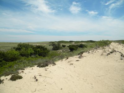
Amagansett National Wildlife Refuge is a coastal property on Long Island's Atlantic side that spans varied habitats from open beach to vegetated dunes. The site includes sandy shores, dune ridges, wetland areas, and bog lands that support multiple ecosystem types.

History

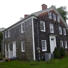
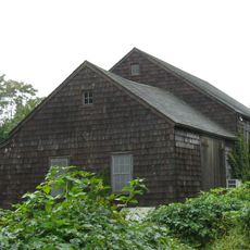
A lifesaving station established in 1902 operated on this coast before being relocated, and the land became a federal wildlife refuge in 1968. This change shifted the focus from human rescue operations to environmental protection.

Culture

The refuge maintains wild coastal landscapes within an urban region, serving as a place where natural and developed areas coexist. Visitors can experience how this land remains connected to local conservation efforts today.

Practical

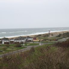
The beach section welcomes visitors, but the dune areas inland remain closed year-round to protect sensitive plants and animals. Visitors should plan to explore primarily the shoreline while respecting marked boundaries.

Did you know?

The dune landscape shelters uncommon orchid species that flourish in the sandy terrain, though few visitors realize these plants are growing there. This hidden botanical wealth attracts those who know where to look.

Location
Inception
1968
GPS coordinates
40.96970,-72.12640
Latest update
December 12, 2025 12:02

AroundUs brings together thousands of curated places, local tips, and hidden gems, enriched daily by 60,000 contributors worldwide. Discover all places nearby (New York).

Around this place
Grey Gardens
United States of America

Grey Gardens

8.3 km
United States of America

Sag Harbor Hills, Azurest, and Ninevah Beach Subdivisions Historic District

12.9 km
Hither Hills State Park
United States of America

Hither Hills State Park

10.8 km
Pollock-Krasner House and Studio
United States of America

Pollock-Krasner House and Studio

6.5 km
Hook Windmill
United States of America

Hook Windmill

4.9 km
Bunshaft Residence
United States of America

Bunshaft Residence

9.4 km
Thomas Moran House
United States of America

Thomas Moran House

6 km
Mulford Farmhouse
United States of America

Mulford Farmhouse

5.6 km
Briar Patch Road Historic District
United States of America

Briar Patch Road Historic District

9.1 km
Hayground Windmill
United States of America

Hayground Windmill

3.7 km
John Lyon Gardiner Mill Cottage
United States of America

John Lyon Gardiner Mill Cottage

5.7 km
East Hampton Village District
United States of America

East Hampton Village District

5.7 km
Wainscott Windmill
United States of America

Wainscott Windmill

10.1 km
Jericho Historic District
United States of America

Jericho Historic District

7.9 km
Pantigo Windmill
United States of America

Pantigo Windmill

5.6 km
Amelia Cottage Museum
United States of America

Amelia Cottage Museum

1.6 km
Pantigo Road Historic District
United States of America

Pantigo Road Historic District

4.3 km
Stephen Sherrill House
United States of America

Stephen Sherrill House

4.6 km
Saint Thomas' Chapel
United States of America

Saint Thomas' Chapel

1.5 km
North Main Street Historic District
United States of America

North Main Street Historic District

4.9 km
Ambrose Parsons House
United States of America

Ambrose Parsons House

6.2 km
Jones Road Historic District
United States of America

Jones Road Historic District

7.8 km
Egypt Lane Historic District
United States of America

Egypt Lane Historic District

4.5 km
Buell's Lane Historic District
United States of America

Buell's Lane Historic District

6.2 km
Thomas Strong House
United States of America

Thomas Strong House

11.2 km
Pleasants House
United States of America

Pleasants House

1.3 km
Napeague State Park
United States of America

Napeague State Park

4.7 km
Pollock-Krasner House
United States of America

Pollock-Krasner House

6.5 km
Show the full map
« Amagansett National Wildlife Refuge - Wildlife refuge on Long Island's Atlantic coast, New York » is provided by Around Us (aroundus.com). Images and texts are derived from Wikimedia project under a Creative Commons license. You are allowed to copy, distribute, and modify copies of this page, under the conditions set by the license, as long as this note is clearly visible.

Discover hidden gems everywhere you go!

From secret cafés to breathtaking viewpoints, skip the crowded tourist spots and find places that match your style. Our app makes it easy with voice search, smart filtering, route optimization, and insider tips from travelers worldwide. Download now for the complete mobile experience.

Around Us App Screenshot

A unique approach to discovering new places

Le Figaro

All the places worth exploring

France Info

A tailor-made excursion in just a few clicks

20 Minutes

Around Us
Travel Guide & Maps
Download

Send to your phone

QR Code
1

Open the camera app on your mobile.

2

Point at the QR code with your camera. A notification will appear.

3

Tap the notification to open the link.