Ambler Heights Historic District

Log in to your account

AroundUs is a community-driven map of interesting places, built by curious explorers like you. It grows with every review, story, and photo you share.
Connect to save your favorite spots, contribute locations, and create personalized routes.
Continue with Google
Continue with Apple
Continue with X
Continue with Facebook
Continue with email
By continuing, you accept our Terms and Conditions and our Privacy Policy
Create an account
Add to collection
Map
Suggest a change
Share

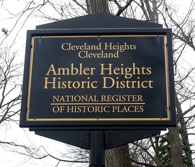
Ambler Heights Historic District, Historic district in Cleveland Heights, US.

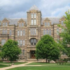
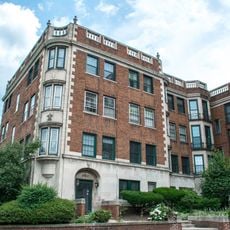
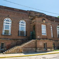
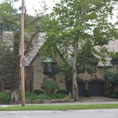
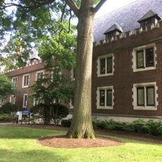
Ambler Heights Historic District is a residential neighborhood in Cleveland Heights containing around 112 buildings spread across roughly 73 acres. The homes date from the late 1800s and early 1900s and display styles such as Colonial Revival and Tudor Revival that were fashionable at the time.

The land was originally farmland acquired by Dr. Nathan Hardy Ambler, a wealthy dentist, before development began in 1903. The neighborhood grew during an era when Cleveland was one of the nation's major industrial cities and wealthy residents sought peaceful residential areas outside the urban center.

The homes reflect the taste and aspirations of Cleveland's wealthy families during the Progressive Era. Walking through the streets, you can see how much care went into architectural details and the choice of quality materials that still shape the neighborhood's character today.

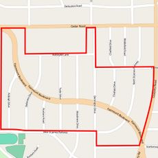
The district stretches from Martin Luther King Jr. Boulevard to Cedar Glen and from N. Park Boulevard to Harcourt Drive. It is a residential area best explored on foot, allowing you to enjoy the different architectural styles and the quiet, tree-lined streets.

The homes were designed and built according to strict specifications set by Cleveland's wealthiest families. This was not a typical subdivision but rather a private development with high standards for architecture and lot size, giving the neighborhood its exclusive character that endures today.

Location: Cleveland Heights

GPS coordinates: 41.49722,-81.60111

Latest update: December 14, 2025 16:47

Photos
Around this place
Cleveland Museum of Art
United States of America

Cleveland Museum of Art

1.6 km
Cleveland Museum of Natural History
United States of America

Cleveland Museum of Natural History

323 m
James A. Garfield Memorial
United States of America

James A. Garfield Memorial

1.6 km
Severance Hall
United States of America

Severance Hall

1.2 km
The Cleveland Museum of Art
United States of America

The Cleveland Museum of Art

1.5 km
Cleveland Botanical Garden
United States of America

Cleveland Botanical Garden

1.7 km
Luna Park, Cleveland
United States of America

Luna Park, Cleveland

1.2 km
Museum of Contemporary Art Cleveland
United States of America

Museum of Contemporary Art Cleveland

1.3 km
Imperial Red Cross Easter Egg
United States of America

Imperial Red Cross Easter Egg

1.6 km
Children's Museum of Cleveland
United States of America

Children's Museum of Cleveland

1.1 km
Wade Park
United States of America

Wade Park

1.7 km
Dittrick Museum of Medical History
United States of America

Dittrick Museum of Medical History

1.2 km
Adelbert Hall
United States of America

Adelbert Hall

1.1 km
Cedar Glen Apartments
United States of America

Cedar Glen Apartments

334 m
One University Circle
United States of America

One University Circle

1.1 km
Allen Memorial Medical Library
United States of America

Allen Memorial Medical Library

1.2 km
First Church of Christ, Scientist
United States of America

First Church of Christ, Scientist

660 m
Flora Stone Mather College Historic District
United States of America

Flora Stone Mather College Historic District

1.4 km
Michelson-Morley Memorial Fountain
United States of America

Michelson-Morley Memorial Fountain

973 m
Cozad-Bates House
United States of America

Cozad-Bates House

1.2 km
Euclid Golf Allotment
United States of America

Euclid Golf Allotment

1.3 km
Alta Public Library
United States of America

Alta Public Library

1.3 km
Fairhill Road Village
United States of America

Fairhill Road Village

585 m
Woodland-Larchmere Commercial Historic District
United States of America

Woodland-Larchmere Commercial Historic District

1.3 km
Peter B. Lewis Building
United States of America

Peter B. Lewis Building

1.5 km
Mather House
United States of America

Mather House

1.3 km
Mayfield Theater
United States of America

Mayfield Theater

1.3 km
The Michelson-Morley Experiment
United States of America

The Michelson-Morley Experiment

927 m
Show the full map
Reviews

Visited this place? Tap the stars to rate it and share your experience / photos with the community! Try now! You can cancel it anytime.

« Ambler Heights Historic District - Historic district in Cleveland Heights, US » is provided by Around Us (aroundus.com). Images and texts are derived from Wikimedia project under a Creative Commons license. You are allowed to copy, distribute, and modify copies of this page, under the conditions set by the license, as long as this note is clearly visible.

Discover hidden gems everywhere you go!

From secret cafés to breathtaking viewpoints, skip the crowded tourist spots and find places that match your style. Our app makes it easy with voice search, smart filtering, route optimization, and insider tips from travelers worldwide. Download now for the complete mobile experience.

Around Us App Screenshot

A unique approach to discovering new places

Le Figaro

All the places worth exploring

France Info

A tailor-made excursion in just a few clicks

20 Minutes