Enable Location

We need your location to show you interesting places around you

Discover nearby places

Find interesting locations and hidden gems around you

Precise directions

Get accurate directions and distances to places

Your location is never shared with other users. It's only used when you tap the location button.

Bath Covered Bridge

Log in to your account

Start exploring — it's free

Trusted by 61,887 travelers worldwide

Continue with Google
Continue with Apple
or

We will send you a code to connect

By continuing, you accept our Terms and Conditions and our Privacy Policy

Check your inbox

We've sent a pincode in your inbox. Please enter the code below.

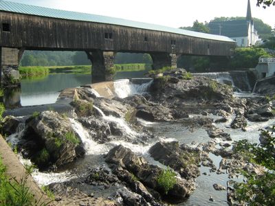
Bath Covered Bridge, Covered bridge in Bath, New Hampshire, US.

Bath Covered Bridge crosses the Ammonoosuc River and measures 374 feet (114 m) in length, with a dark red wooden roof sheltering the roadway and side walls. The structure rests on stone abutments at both banks and shows exposed beams inside that run diagonally.

Since 1794, a crossing has linked both shores here, though floods and fire destroyed the first four versions. The present structure dates from 1832 and received additional laminated arch supports during the 1920s.

The name recalls the first wooden crossing built in 1794 to replace a ford. On warm afternoons, locals with children pause here to look through the side openings at the water below.

The crossing sits at the junction of US 302 and NH 10 and remains open to cars and pedestrians. Following major repairs in 2014, the roadway stays level and easy to drive across.

The roof carries the original red oil paint, refreshed every few decades to maintain protection. In winter, icicles sometimes form along the lower edges of the side walls when the river stays cold.

The community of curious travelers

AroundUs brings together thousands of curated places, local tips, and hidden gems, enriched daily by 60,000 contributors worldwide.

Start exploring
Location
Length
114 m
GPS coordinates
44.16694,-71.96750
Latest update
December 5, 2025 22:28
Around this place
The Frost Place
United States of America

The Frost Place

17.5 km
Comerford Reservoir
United States of America

Comerford Reservoir

17.8 km
Wells River Bridge
United States of America

Wells River Bridge

6 km
Haverhill-Bath Covered Bridge
United States of America

Haverhill-Bath Covered Bridge

5.7 km
Bedell Covered Bridge
United States of America

Bedell Covered Bridge

16 km
Ranger Bridge
United States of America

Ranger Bridge

6 km
Brick Store
United States of America

Brick Store

115 m
Swiftwater Covered Bridge
United States of America

Swiftwater Covered Bridge

3.9 km
Dow Academy
United States of America

Dow Academy

18.7 km
Bedell Bridge State Park
United States of America

Bedell Bridge State Park

16 km
Oxbow Historic District
United States of America

Oxbow Historic District

10.2 km
Daniel Carr House
United States of America

Daniel Carr House

7.1 km
Jeremiah Hutchins Tavern
United States of America

Jeremiah Hutchins Tavern

2.2 km
Haverhill Corner Historic District
United States of America

Haverhill Corner Historic District

17 km
McIndoes Academy
United States of America

McIndoes Academy

13.3 km
Wildwood Hall
United States of America

Wildwood Hall

14.2 km
Newbury Town House
United States of America

Newbury Town House

14.4 km
Alice Lord Goodine House
United States of America

Alice Lord Goodine House

18.7 km
West Newbury Village Historic District
United States of America

West Newbury Village Historic District

17.1 km
Goodall-Woods Law Office
United States of America

Goodall-Woods Law Office

2.1 km
Lind Houses
United States of America

Lind Houses

13.8 km
Woodsville Opera House
United States of America

Woodsville Opera House

5.9 km
South Newbury Village Historic District
United States of America

South Newbury Village Historic District

16.5 km
Bayley Historic District
United States of America

Bayley Historic District

11.2 km
Barnet Center Historic District
United States of America

Barnet Center Historic District

18.7 km
Brock Hill Schoolhouse
United States of America

Brock Hill Schoolhouse

15.8 km
Stone Iron Furnace Museum
United States of America

Stone Iron Furnace Museum

18.4 km
Wells River Village Historic District
United States of America

Wells River Village Historic District

6.6 km
Show the full map
« Bath Covered Bridge - Covered bridge in Bath, New Hampshire, US » is provided by Around Us (aroundus.com). Images and texts are derived from Wikimedia project under a Creative Commons license. You are allowed to copy, distribute, and modify copies of this page, under the conditions set by the license, as long as this note is clearly visible.

Discover hidden gems everywhere you go!

From secret cafés to breathtaking viewpoints, skip the crowded tourist spots and find places that match your style. Our app makes it easy with voice search, smart filtering, route optimization, and insider tips from travelers worldwide. Download now for the complete mobile experience.

Around Us App Screenshot

A unique approach to discovering new places

Le Figaro

All the places worth exploring

France Info

A tailor-made excursion in just a few clicks

20 Minutes

Around Us
Travel Guide & Maps
Download

Send to your phone

QR Code
1

Open the camera app on your mobile.

2

Point at the QR code with your camera. A notification will appear.

3

Tap the notification to open the link.