Enable Location

We need your location to show you interesting places around you

Discover nearby places

Find interesting locations and hidden gems around you

Precise directions

Get accurate directions and distances to places

Your location is never shared with other users. It's only used when you tap the location button.

Comerford Reservoir

Log in to your account

Start exploring — it's free

Trusted by 62,302 travelers worldwide

Continue with Google
Continue with Apple
or

We will send you a code to connect

By continuing, you accept our Terms and Conditions and our Privacy Policy

Check your inbox

We've sent a pincode in your inbox. Please enter the code below.

Comerford Reservoir

Comerford Reservoir, body of water

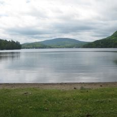
Comerford Reservoir is a large impoundment created by a concrete dam on the Connecticut River along the border between Vermont and New Hampshire. The water extends about 8 miles upstream from the dam and is surrounded by forests and hills that create an open, natural landscape.

The facility was created in 1930 when the Frank D. Comerford Dam was built to generate electricity and manage flood control along the Connecticut River. The project was part of a broader regional effort to harness the river's power for supplying energy to New England.

The dam is named after Frank D. Comerford, a regional business leader of the early 20th century. Today, the site serves as a gathering place where local fishers and boaters come regularly to spend their leisure time on the water.

The site has public boat ramps, picnic areas, and trails for visitors, with some areas accessible for people with disabilities. Keep in mind that water levels fluctuate seasonally and dam releases can happen suddenly, so pay attention to safety signs and respect the natural setting.

The dam operates as a run-of-river facility, meaning it uses the natural flow of the Connecticut River rather than storing large amounts of water like traditional reservoirs. Despite this more eco-friendly design, the structure has blocked fish migration and prevented Atlantic salmon from reaching their historic spawning grounds.

The community of curious travelers

AroundUs brings together thousands of curated places, local tips, and hidden gems, enriched daily by 60,000 contributors worldwide.

Start exploring
Location
Location
Elevation above the sea
197 m
GPS coordinates
44.32528,-72.00083
Latest update
February 9, 2026 08:22
Around this place
Moore Reservoir
United States of America

Moore Reservoir

10 km
St. Johnsbury Athenaeum
United States of America

St. Johnsbury Athenaeum

10.5 km
Fairbanks Museum and Planetarium
United States of America

Fairbanks Museum and Planetarium

10.7 km
Harvey's Lake
United States of America

Harvey's Lake

11.5 km
Dog Mountain
United States of America

Dog Mountain

12.3 km
Greenbanks Hollow Covered Bridge
United States of America

Greenbanks Hollow Covered Bridge

11.3 km
Elkins Tavern
United States of America

Elkins Tavern

13.2 km
Whitehill House
United States of America

Whitehill House

15.3 km
Caleb H. Marshall House
United States of America

Caleb H. Marshall House

10.8 km
Lee Farm
United States of America

Lee Farm

11.5 km
William and Agnes Gilkerson Farm
United States of America

William and Agnes Gilkerson Farm

10.5 km
Jeremiah Hutchins Tavern
United States of America

Jeremiah Hutchins Tavern

17 km
Railroad Street Historic District
United States of America

Railroad Street Historic District

10.3 km
McIndoes Academy
United States of America

McIndoes Academy

8.5 km
Whittier House
United States of America

Whittier House

11.4 km
St. Johnsbury Main Street Historic District
United States of America

St. Johnsbury Main Street Historic District

10.5 km
Shearer and Corser Double House
United States of America

Shearer and Corser Double House

11.1 km
Franklin Fairbanks House
United States of America

Franklin Fairbanks House

10.5 km
Barnet Center Historic District
United States of America

Barnet Center Historic District

6.9 km
St. Johnsbury Historic District
United States of America

St. Johnsbury Historic District

10.4 km
Peacham Corner Historic District
United States of America

Peacham Corner Historic District

13.7 km
Phineas Thurston House
United States of America

Phineas Thurston House

4.9 km
Judge David Hibbard Homestead
United States of America

Judge David Hibbard Homestead

16.2 km
Morency Paint Shop and Apartment Building
United States of America

Morency Paint Shop and Apartment Building

10.6 km
Cote Apartment House
United States of America

Cote Apartment House

10.8 km
Maple Street-Clarks Avenue Historic District
United States of America

Maple Street-Clarks Avenue Historic District

10.8 km
The Dog Chapel
United States of America

The Dog Chapel

12.3 km
Peacham
United States of America

Peacham

13.5 km
Show the full map
« Comerford Reservoir - body of water » is provided by Around Us (aroundus.com). Images and texts are derived from Wikimedia project under a Creative Commons license. You are allowed to copy, distribute, and modify copies of this page, under the conditions set by the license, as long as this note is clearly visible.

Discover hidden gems everywhere you go!

From secret cafés to breathtaking viewpoints, skip the crowded tourist spots and find places that match your style. Our app makes it easy with voice search, smart filtering, route optimization, and insider tips from travelers worldwide. Download now for the complete mobile experience.

Around Us App Screenshot

A unique approach to discovering new places

Le Figaro

All the places worth exploring

France Info

A tailor-made excursion in just a few clicks

20 Minutes

Around Us
Travel Guide & Maps
Download

Send to your phone

QR Code
1

Open the camera app on your mobile.

2

Point at the QR code with your camera. A notification will appear.

3

Tap the notification to open the link.