Ranger Bridge

Log in to your account

AroundUs is a community-driven map of interesting places, built by curious explorers like you. It grows with every review, story, and photo you share.
Connect to save your favorite spots, contribute locations, and create personalized routes.
Continue with Google
Continue with Apple
Continue with X
Continue with Facebook
Continue with email
By continuing, you accept our Terms and Conditions and our Privacy Policy
Create an account
Add to collection
Map
Suggest a change
Share

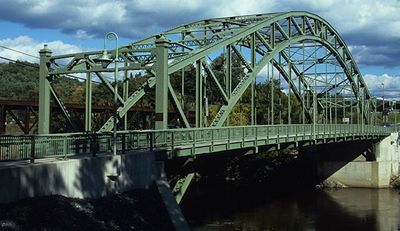
Ranger Bridge, Steel arch bridge between Wells River and Woodsville, United States.

Ranger Bridge is a steel arch truss bridge that crosses the Connecticut River between New Hampshire and Vermont along U.S. Route 302. The structure features a three-hinged arch design that spans the river in a single graceful curve.

This bridge was built in 1923 by the Boston Bridge Company following a design by J.R. Worcester. It replaced an earlier bridge that was destroyed by flooding.

The bridge stands as the oldest steel arch crossing over the Connecticut River, demonstrating engineering methods from the early twentieth century.

The bridge serves as a major traffic corridor, used daily by cars and pedestrians to cross between the two states. Both vehicle and foot traffic cross safely thanks to its sturdy modern infrastructure maintained through regular repairs.

Located at coordinates 44°09′14″N and 72°02′27″W, this bridge serves as a critical transportation link between two New England states.

Location: New Hampshire

Location: Vermont

GPS coordinates: 44.15390,-72.04080

Latest update: December 14, 2025 09:45

Photos
Around this place
Bath Covered Bridge
United States of America

Bath Covered Bridge

6 km
Harvey's Lake
United States of America

Harvey's Lake

17.4 km
Comerford Reservoir
United States of America

Comerford Reservoir

19.3 km
Wells River Bridge
United States of America

Wells River Bridge

53 m
Haverhill-Bath Covered Bridge
United States of America

Haverhill-Bath Covered Bridge

332 m
Bedell Covered Bridge
United States of America

Bedell Covered Bridge

12.4 km
Swiftwater Covered Bridge
United States of America

Swiftwater Covered Bridge

7.5 km
Bedell Bridge State Park
United States of America

Bedell Bridge State Park

12.4 km
Whitehill House
United States of America

Whitehill House

16.3 km
Oxbow Historic District
United States of America

Oxbow Historic District

6.6 km
Daniel Carr House
United States of America

Daniel Carr House

5.8 km
Jeremiah Hutchins Tavern
United States of America

Jeremiah Hutchins Tavern

8.2 km
Haverhill Corner Historic District
United States of America

Haverhill Corner Historic District

13.8 km
Wildwood Hall
United States of America

Wildwood Hall

10.2 km
McIndoes Academy
United States of America

McIndoes Academy

12.5 km
Newbury Town House
United States of America

Newbury Town House

8.6 km
Alice Lord Goodine House
United States of America

Alice Lord Goodine House

13.8 km
West Newbury Village Historic District
United States of America

West Newbury Village Historic District

12.2 km
Goodall-Woods Law Office
United States of America

Goodall-Woods Law Office

8.1 km
Lind Houses
United States of America

Lind Houses

8.6 km
Woodsville Opera House
United States of America

Woodsville Opera House

245 m
J. R. Darling Store
United States of America

J. R. Darling Store

13.9 km
Bayley Historic District
United States of America

Bayley Historic District

7.5 km
South Newbury Village Historic District
United States of America

South Newbury Village Historic District

12.6 km
Barnet Center Historic District
United States of America

Barnet Center Historic District

18 km
Elwin Chase House
United States of America

Elwin Chase House

16.3 km
Wells River Village Historic District
United States of America

Wells River Village Historic District

609 m
Newbury Village Historic District
United States of America

Newbury Village Historic District

8.6 km
Show the full map
Reviews

Visited this place? Tap the stars to rate it and share your experience / photos with the community! Try now! You can cancel it anytime.

« Ranger Bridge - Steel arch bridge between Wells River and Woodsville, United States » is provided by Around Us (aroundus.com). Images and texts are derived from Wikimedia project under a Creative Commons license. You are allowed to copy, distribute, and modify copies of this page, under the conditions set by the license, as long as this note is clearly visible.

Discover hidden gems everywhere you go!

From secret cafés to breathtaking viewpoints, skip the crowded tourist spots and find places that match your style. Our app makes it easy with voice search, smart filtering, route optimization, and insider tips from travelers worldwide. Download now for the complete mobile experience.

Around Us App Screenshot

A unique approach to discovering new places

Le Figaro

All the places worth exploring

France Info

A tailor-made excursion in just a few clicks

20 Minutes