Enable Location

We need your location to show you interesting places around you

Discover nearby places

Find interesting locations and hidden gems around you

Precise directions

Get accurate directions and distances to places

Your location is never shared with other users. It's only used when you tap the location button.

Swiftwater Covered Bridge

Log in to your account

Start exploring — it's free

Trusted by 61,897 travelers worldwide

Continue with Google
Continue with Apple
or

We will send you a code to connect

By continuing, you accept our Terms and Conditions and our Privacy Policy

Check your inbox

We've sent a pincode in your inbox. Please enter the code below.

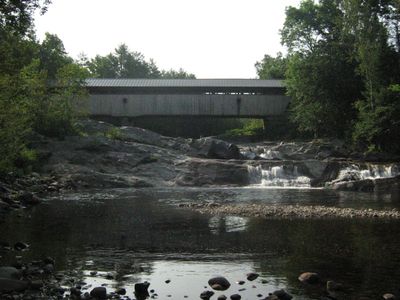
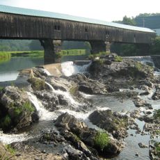
Swiftwater Covered Bridge, Historic covered bridge in Bath, New Hampshire.

Swiftwater Covered Bridge is a historic wooden structure that crosses the Wild Ammonoosuc River in Bath. The bridge features vertical timber siding and a metal roof, with granite abutments supporting its span across the water.

The bridge was built in 1849 to replace three earlier structures destroyed by repeated flooding at this river crossing. The recurring destruction from 1810 to 1828 demonstrated the challenges of maintaining infrastructure along the Wild Ammonoosuc.

The bridge represents the engineering methods of early American builders, showcasing the Paddleford truss design that characterized 19th-century New England construction techniques.

You can reach the bridge from Valley Road and walk across it to view the structure up close. The crossing is straightforward and the setting offers a good spot to examine the construction details and surrounding landscape.

The bridge features a distinctive architectural detail that sets it apart: vertical timber planking does not extend to the full height under the roof, leaving an open strip along the sides. This gap is a signature element of its original design.

The community of curious travelers

AroundUs brings together thousands of curated places, local tips, and hidden gems, enriched daily by 60,000 contributors worldwide.

Start exploring
Location
GPS coordinates
44.13417,-71.95139
Latest update
December 14, 2025 16:42
Around this place
Mount Moosilauke
United States of America

Mount Moosilauke

15.6 km
Bath Covered Bridge
United States of America

Bath Covered Bridge

3.9 km
Lost River Reservation
United States of America

Lost River Reservation

17.2 km
The Frost Place
United States of America

The Frost Place

17.8 km
Lake Tarleton
United States of America

Lake Tarleton

17.7 km
Wells River Bridge
United States of America

Wells River Bridge

7.5 km
Haverhill-Bath Covered Bridge
United States of America

Haverhill-Bath Covered Bridge

7.2 km
Bedell Covered Bridge
United States of America

Bedell Covered Bridge

13.9 km
Ranger Bridge
United States of America

Ranger Bridge

7.5 km
Mount Blue
United States of America

Mount Blue

15.6 km
United States of America

Lake Tarleton State Park

16.9 km
Bedell Bridge State Park
United States of America

Bedell Bridge State Park

13.9 km
Oxbow Historic District
United States of America

Oxbow Historic District

8.8 km
Daniel Carr House
United States of America

Daniel Carr House

5 km
Jeremiah Hutchins Tavern
United States of America

Jeremiah Hutchins Tavern

4.9 km
Haverhill Corner Historic District
United States of America

Haverhill Corner Historic District

14.6 km
Wildwood Hall
United States of America

Wildwood Hall

12.4 km
McIndoes Academy
United States of America

McIndoes Academy

17.1 km
Newbury Town House
United States of America

Newbury Town House

14.3 km
West Newbury Village Historic District
United States of America

West Newbury Village Historic District

16 km
Goodall-Woods Law Office
United States of America

Goodall-Woods Law Office

4.7 km
Lind Houses
United States of America

Lind Houses

16 km
Woodsville Opera House
United States of America

Woodsville Opera House

7.3 km
South Newbury Village Historic District
United States of America

South Newbury Village Historic District

14.6 km
Bayley Historic District
United States of America

Bayley Historic District

9.6 km
Stone Iron Furnace Museum
United States of America

Stone Iron Furnace Museum

19 km
Wells River Village Historic District
United States of America

Wells River Village Historic District

8 km
Newbury Village Historic District
United States of America

Newbury Village Historic District

10.6 km
Show the full map
« Swiftwater Covered Bridge - Historic covered bridge in Bath, New Hampshire » is provided by Around Us (aroundus.com). Images and texts are derived from Wikimedia project under a Creative Commons license. You are allowed to copy, distribute, and modify copies of this page, under the conditions set by the license, as long as this note is clearly visible.

Discover hidden gems everywhere you go!

From secret cafés to breathtaking viewpoints, skip the crowded tourist spots and find places that match your style. Our app makes it easy with voice search, smart filtering, route optimization, and insider tips from travelers worldwide. Download now for the complete mobile experience.

Around Us App Screenshot

A unique approach to discovering new places

Le Figaro

All the places worth exploring

France Info

A tailor-made excursion in just a few clicks

20 Minutes

Around Us
Travel Guide & Maps
Download

Send to your phone

QR Code
1

Open the camera app on your mobile.

2

Point at the QR code with your camera. A notification will appear.

3

Tap the notification to open the link.