Enable Location

We need your location to show you interesting places around you

Discover nearby places

Find interesting locations and hidden gems around you

Precise directions

Get accurate directions and distances to places

Your location is never shared with other users. It's only used when you tap the location button.

Lake Tarleton

Log in to your account

Start exploring — it's free

Trusted by 62,314 travelers worldwide

Continue with Google
Continue with Apple
or

We will send you a code to connect

By continuing, you accept our Terms and Conditions and our Privacy Policy

Check your inbox

We've sent a pincode in your inbox. Please enter the code below.

Lake Tarleton

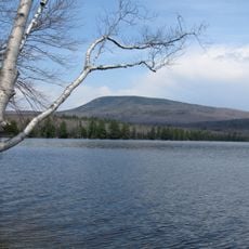
Lake Tarleton, lake in New Hampshire, United States

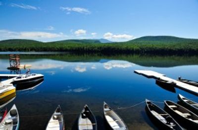
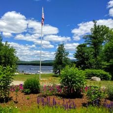
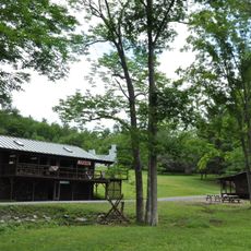
Lake Tarleton is a large, clear body of water in Grafton County, New Hampshire, surrounded by forests and hills. The lake is managed by a 48-acre state park featuring an unguarded swimming beach and picnic areas for visitors.

The water body was named after an early settler who established himself in this region. Over time, the lake and surrounding area became a popular recreational destination for residents and visitors.

The lake takes its name from an early settler in the region. Today it serves as a gathering place where visitors swim, fish, and enjoy outdoor recreation in a natural setting.

The lake can be accessed from two main points: the state park at the northern end with beach and picnic areas, and a boat launch ramp at the southern end for motorized boats. Pets are not allowed in the park, and visitors should remove all trash and check boats for plants and mud to prevent invasive species.

The lake remains free of invasive plant species, which is uncommon among local waters where many others struggle with unwanted aquatic weeds. This clean water quality is maintained through careful boat inspection practices before launching.

The community of curious travelers

AroundUs brings together thousands of curated places, local tips, and hidden gems, enriched daily by 60,000 contributors worldwide.

Start exploring
Location
GPS coordinates
43.97556,-71.96306
Latest update
February 9, 2026 08:22
Around this place
Mount Moosilauke
United States of America

Mount Moosilauke

11.8 km
Hubbard Brook Experimental Forest
United States of America

Hubbard Brook Experimental Forest

17.7 km
Lost River Reservation
United States of America

Lost River Reservation

15.9 km
Smarts Mountain
United States of America

Smarts Mountain

17.6 km
Camp Walt Whitman
United States of America

Camp Walt Whitman

3 km
Bedell Covered Bridge
United States of America

Bedell Covered Bridge

11.8 km
Morey Memorial Bridge
United States of America

Morey Memorial Bridge

16.1 km
Piermont Bridge
United States of America

Piermont Bridge

12 km
Mount Blue
United States of America

Mount Blue

13 km
United States of America

Lake Tarleton State Park

1.4 km
Lanakila Camp
United States of America

Lanakila Camp

15 km
Swiftwater Covered Bridge
United States of America

Swiftwater Covered Bridge

17.7 km
Bedell Bridge State Park
United States of America

Bedell Bridge State Park

11.7 km
Orford Street Historic District
United States of America

Orford Street Historic District

15.9 km
Oxbow Historic District
United States of America

Oxbow Historic District

14.9 km
Daniel Carr House
United States of America

Daniel Carr House

15.2 km
Haverhill Corner Historic District
United States of America

Haverhill Corner Historic District

10.2 km
Wildwood Hall
United States of America

Wildwood Hall

13.3 km
Bridge 22
United States of America

Bridge 22

13.4 km
Newbury Town House
United States of America

Newbury Town House

19.5 km
West Newbury Village Historic District
United States of America

West Newbury Village Historic District

16.1 km
Fairlee Town Hall
United States of America

Fairlee Town Hall

16.2 km
South Newbury Village Historic District
United States of America

South Newbury Village Historic District

12.6 km
Bayley Historic District
United States of America

Bayley Historic District

14.2 km
Sawyer-Medlicott House
United States of America

Sawyer-Medlicott House

11.4 km
Moses Kent House
United States of America

Moses Kent House

19.8 km
Orford-Fairlee Covered Bridge
United States of America

Orford-Fairlee Covered Bridge

16.1 km
Newbury Village Historic District
United States of America

Newbury Village Historic District

13.7 km
Show the full map
« Lake Tarleton - lake in New Hampshire, United States » is provided by Around Us (aroundus.com). Images and texts are derived from Wikimedia project under a Creative Commons license. You are allowed to copy, distribute, and modify copies of this page, under the conditions set by the license, as long as this note is clearly visible.

Discover hidden gems everywhere you go!

From secret cafés to breathtaking viewpoints, skip the crowded tourist spots and find places that match your style. Our app makes it easy with voice search, smart filtering, route optimization, and insider tips from travelers worldwide. Download now for the complete mobile experience.

Around Us App Screenshot

A unique approach to discovering new places

Le Figaro

All the places worth exploring

France Info

A tailor-made excursion in just a few clicks

20 Minutes

Around Us
Travel Guide & Maps
Download

Send to your phone

QR Code
1

Open the camera app on your mobile.

2

Point at the QR code with your camera. A notification will appear.

3

Tap the notification to open the link.