Lost River Reservation, Protected area in White Mountains, New Hampshire, United States.
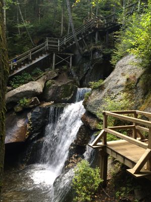
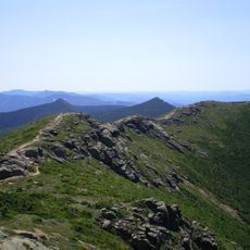
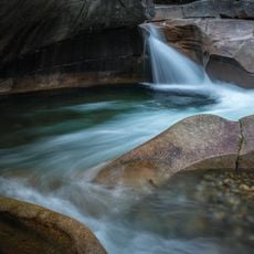
Lost River Reservation is a protected area in the White Mountains covering roughly 157 acres. A mile-long boardwalk winds through a gorge with high granite walls and large boulder formations, offering access to eleven caves via stairs and wooden walkways that guide visitors safely through the landscape.
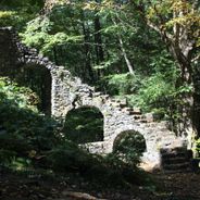
The area once supported nineteenth-century logging operations, with a mill site and water wheel still standing as traces of that industrial past. These structures show how the river's power was harnessed for early manufacturing activities in the region.
The Society for the Protection of New Hampshire Forests manages this area to connect people with the natural world through hands-on experience. You can see how the organization's work keeps the space accessible while protecting the landscape from damage.
The boardwalk and stairs are designed for straightforward access to the caves and river views throughout the gorge. The pathways are well-maintained, but keep in mind the gorge can be damp and narrow in places, especially during or after rain.
The river loses its name because it vanishes underground through narrow cracks between enormous granite blocks before rejoining the Pemigewasset River. This disappearing and reappearing of water is a geological oddity that sets the place apart from typical river valleys.
Location: New Hampshire
Website: http://findlostriver.com
GPS coordinates: 44.03778,-71.78389
Latest update: December 6, 2025 17:41
New Hampshire reveals a land where the White Mountains have shaped the skyline for millennia. Between northern coniferous forests and southeastern Atlantic coasts, this New England state features waterfalls cascading over granite, glacial passes carved 15,000 years ago, and industrial villages embedded in red stone. Archaeological sites, lighthouses guiding ships on Piscataqua, and estates where early 20th-century artists shaped American identity await discovery. Trails wind through gorges, along lakes reflecting peaks, and through forests where remnants of old foundries remain. Autumn light illuminates maple trees, winter turns ravines into ice amphitheaters, and spring causes waterfalls to roar. From Mount Monadnock to the Shoals Islands, New Hampshire offers a varied geography where each hill, waterfall, and stone bears witness to a deeply rooted natural and human story within the landscape of New England.
Old Man of the Mountain
15.9 km
Mount Lafayette
17.7 km
Mount Moosilauke
4.1 km
Flume Gorge
11.4 km
Franconia Notch
16.7 km
Franconia Notch State Park
14.2 km
Cannon Mountain
14.9 km
Hubbard Brook Experimental Forest
11.9 km
Mount Lincoln
16.6 km
Mount Liberty
14.3 km
The Frost Place
19.6 km
Mount Flume
14.8 km
White Mountain Central Railroad
7.9 km
Whale's Tale Water Park
8.6 km
Camp Walt Whitman
18 km
Lake Tarleton
15.9 km
Owl's Head
18.6 km
Profile House
16.5 km
Scar Ridge
15.1 km
Mount Blue (New Hampshire)
3 km
Lake Tarleton State Park
16.5 km
Swiftwater Covered Bridge
17.2 km
New England Ski Museum
16.6 km
Daniel Carr House
19.2 km
Little Haystack Mountain
15.9 km
The Basin
12.3 km
Clark's Bridge
7.8 km
Flume Covered Bridge
11 kmVisited this place? Tap the stars to rate it and share your experience / photos with the community! Try now! You can cancel it anytime.
Discover hidden gems everywhere you go!
From secret cafés to breathtaking viewpoints, skip the crowded tourist spots and find places that match your style. Our app makes it easy with voice search, smart filtering, route optimization, and insider tips from travelers worldwide. Download now for the complete mobile experience.
A unique approach to discovering new places❞
— Le Figaro
All the places worth exploring❞
— France Info
A tailor-made excursion in just a few clicks❞
— 20 Minutes