Enable Location

We need your location to show you interesting places around you

Discover nearby places

Find interesting locations and hidden gems around you

Precise directions

Get accurate directions and distances to places

Your location is never shared with other users. It's only used when you tap the location button.

Haverhill-Bath Covered Bridge

Log in to your account

Start exploring — it's free

Trusted by 61,899 travelers worldwide

Continue with Google
Continue with Apple
or

We will send you a code to connect

By continuing, you accept our Terms and Conditions and our Privacy Policy

Check your inbox

We've sent a pincode in your inbox. Please enter the code below.

Haverhill-Bath Covered Bridge, Historic covered bridge in Bath and Woodsville, United States

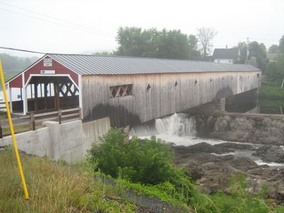
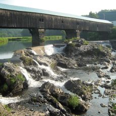
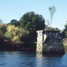
The Haverhill-Bath Covered Bridge is a wooden crossing over the Ammonoosuc River built with a Town lattice truss design and stone foundations. The structure has a distinctive roof profile and is supported by a central pier within the river.

Built in 1829 by Moses Abbott and Leonard Walker, this structure ranks among the oldest covered bridges still in existence in New Hampshire. It has survived multiple major floods while retaining its original stone foundations throughout its long existence.

The bridge features a distinctive design with diamond-shaped openings and rectangular windows in its wooden exterior that visitors can see today. These architectural touches give the crossing its character and make it a recognizable landmark in the river valley.

Following restoration in 2004, this crossing now serves pedestrians with an additional walkway along its eastern side for safe passage. You can walk through at a leisurely pace and take time to observe the construction and river views from within.

The roof has a saltbox profile with one side noticeably steeper than the other, a distinctive feature chosen by the original builders. This unusual design choice remains visible and helps distinguish this crossing from other similar structures in the region.

The community of curious travelers

AroundUs brings together thousands of curated places, local tips, and hidden gems, enriched daily by 60,000 contributors worldwide.

Start exploring
Location
GPS coordinates
44.15440,-72.03670
Latest update
December 13, 2025 17:07
Around this place
Bath Covered Bridge
United States of America

Bath Covered Bridge

5.7 km
Harvey's Lake
United States of America

Harvey's Lake

17.5 km
Comerford Reservoir
United States of America

Comerford Reservoir

19.2 km
Wells River Bridge
United States of America

Wells River Bridge

322 m
Bedell Covered Bridge
United States of America

Bedell Covered Bridge

12.5 km
Ranger Bridge
United States of America

Ranger Bridge

332 m
Swiftwater Covered Bridge
United States of America

Swiftwater Covered Bridge

7.2 km
Bedell Bridge State Park
United States of America

Bedell Bridge State Park

12.5 km
Whitehill House
United States of America

Whitehill House

16.5 km
Oxbow Historic District
United States of America

Oxbow Historic District

6.7 km
Daniel Carr House
United States of America

Daniel Carr House

5.7 km
Jeremiah Hutchins Tavern
United States of America

Jeremiah Hutchins Tavern

7.8 km
Haverhill Corner Historic District
United States of America

Haverhill Corner Historic District

13.9 km
Wildwood Hall
United States of America

Wildwood Hall

10.4 km
McIndoes Academy
United States of America

McIndoes Academy

12.5 km
Newbury Town House
United States of America

Newbury Town House

8.9 km
Alice Lord Goodine House
United States of America

Alice Lord Goodine House

14 km
West Newbury Village Historic District
United States of America

West Newbury Village Historic District

12.4 km
Goodall-Woods Law Office
United States of America

Goodall-Woods Law Office

7.8 km
Lind Houses
United States of America

Lind Houses

8.8 km
Woodsville Opera House
United States of America

Woodsville Opera House

269 m
J. R. Darling Store
United States of America

J. R. Darling Store

14.2 km
Bayley Historic District
United States of America

Bayley Historic District

7.6 km
South Newbury Village Historic District
United States of America

South Newbury Village Historic District

12.8 km
Barnet Center Historic District
United States of America

Barnet Center Historic District

18 km
Elwin Chase House
United States of America

Elwin Chase House

16.6 km
Wells River Village Historic District
United States of America

Wells River Village Historic District

939 m
Newbury Village Historic District
United States of America

Newbury Village Historic District

8.7 km
Show the full map
« Haverhill-Bath Covered Bridge - Historic covered bridge in Bath and Woodsville, United States » is provided by Around Us (aroundus.com). Images and texts are derived from Wikimedia project under a Creative Commons license. You are allowed to copy, distribute, and modify copies of this page, under the conditions set by the license, as long as this note is clearly visible.

Discover hidden gems everywhere you go!

From secret cafés to breathtaking viewpoints, skip the crowded tourist spots and find places that match your style. Our app makes it easy with voice search, smart filtering, route optimization, and insider tips from travelers worldwide. Download now for the complete mobile experience.

Around Us App Screenshot

A unique approach to discovering new places

Le Figaro

All the places worth exploring

France Info

A tailor-made excursion in just a few clicks

20 Minutes

Around Us
Travel Guide & Maps
Download

Send to your phone

QR Code
1

Open the camera app on your mobile.

2

Point at the QR code with your camera. A notification will appear.

3

Tap the notification to open the link.