Chest opened
+${chestReward.xp} XP
Explorer
NOUVEAU ×${chestReward.collectible.quantity}
tapez pour fermer
Chest locked

Open chests in the app

Around Us is built for your phone — chests unlock when you walk, explore and capture nearby places.

Enable Location

We need your location to show you interesting places around you

Discover nearby places

Find interesting locations and hidden gems around you

Precise directions

Get accurate directions and distances to places

Your location is never shared with other users. It's only used when you tap the location button.

Log in to your account

Start exploring — it's free

Trusted by 72,945 travelers worldwide

Continue with Google
Continue with Apple
or

We will send you a code to connect

By continuing, you accept our Terms and Conditions and our Privacy Policy

Check your inbox

We've sent a pincode in your inbox. Please enter the code below.

Beaver Run Reservoir
Discussion Reviews Photo
3.4k Popularity

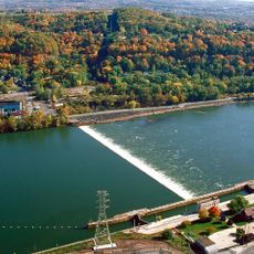
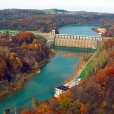
Beaver Run Reservoir, reservoir in Pennsylvania, USA

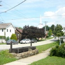
Beaver Run Reservoir is a drinking water reservoir in Westmoreland County, Pennsylvania, situated roughly 23 miles (37 km) east of Pittsburgh. It is managed as a protected water supply and sits within a landscape of wooded hills and open water.

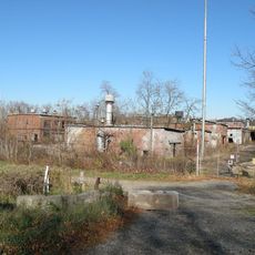
The reservoir was built to secure a long-term water supply for the communities growing around Pittsburgh's eastern suburbs. Starting in 1999, gas extraction was permitted on surrounding lands, and deeper drilling into the Marcellus shale layer followed from 2008.

The reservoir feeds the taps of several towns nearby, and for local residents it is part of everyday life rather than a place to visit. This close connection to drinking water shapes how the surrounding land is managed and kept off-limits to the public.

The reservoir and its surrounding land are closed to the public because they form a protected drinking water zone. Views of the water from nearby roads are possible, but there are no official access points, trails, or facilities for visitors.

A chemical spill in 2013 led to soil cleanup efforts on land that is also officially designated as a drinking water protection zone. The coexistence of active gas extraction and protected water supply on the same property is uncommon for a reservoir of this kind.

The community of curious travelers

AroundUs brings together thousands of curated places, local tips, and hidden gems, enriched daily by 60,000 contributors worldwide.

Start exploring
Location
GPS coordinates
40.48200,-79.55700
Latest update
March 3, 2026 13:59
Around this place
Keystone State Park
United States of America

Keystone State Park

19.2 km
Bushy Run Battlefield
United States of America

Bushy Run Battlefield

15.1 km
Conemaugh Dam
United States of America

Conemaugh Dam

16.2 km
Westmoreland County Courthouse
United States of America

Westmoreland County Courthouse

20 km
Greensburg Downtown Historic District
United States of America

Greensburg Downtown Historic District

19.9 km
Cathedral of the Blessed Sacrament
United States of America

Cathedral of the Blessed Sacrament

19.6 km
Five Star Trail
United States of America

Five Star Trail

19.4 km
Academy Hill Historic District
United States of America

Academy Hill Historic District

19.1 km
Allegheny River Lock and Dam No. 4
United States of America

Allegheny River Lock and Dam No. 4

20 km
Site of Old Hannastown
United States of America

Site of Old Hannastown

16 km
Drake Log Cabin
United States of America

Drake Log Cabin

10.8 km
St. Gertrude Roman Catholic Church
United States of America

St. Gertrude Roman Catholic Church

13.5 km
Fairview Park
United States of America

Fairview Park

8.5 km
Valley Sports Complex
United States of America

Valley Sports Complex

18.6 km
Vandergrift Historic District
United States of America

Vandergrift Historic District

13.4 km
John Walter Farmstead
United States of America

John Walter Farmstead

7.8 km
Saltsburg Historic District
United States of America

Saltsburg Historic District

9 km
Byerly House
United States of America

Byerly House

13.4 km
Salem Crossroads Historic District
United States of America

Salem Crossroads Historic District

7.8 km
Leechburg Bridge
United States of America

Leechburg Bridge

16.6 km
Hannastown Farm
United States of America

Hannastown Farm

15 km
Logans Ferry Powder Works Historic District
United States of America

Logans Ferry Powder Works Historic District

18.7 km
Samuel Patterson House
United States of America

Samuel Patterson House

14.7 km
Mill Bridge
United States of America

Mill Bridge

17.5 km
Slickville Historic District
United States of America

Slickville Historic District

4 km
Westmoreland Museum of American Art
United States of America

Westmoreland Museum of American Art

19.6 km
Conemaugh River Lake Dam
United States of America

Conemaugh River Lake Dam

17.7 km
Palace Theatre
United States of America

Palace Theatre

19.9 km
Show the full map
Reviews
Share your experience

No review yet

Discussions
Start a discussion...

No discussion yet

« Beaver Run Reservoir - reservoir in Pennsylvania, USA » is provided by Around Us (aroundus.com). Images and texts are derived from Wikimedia project under a Creative Commons license. You are allowed to copy, distribute, and modify copies of this page, under the conditions set by the license, as long as this note is clearly visible.

Discover hidden gems everywhere you go!

From secret cafés to breathtaking viewpoints, skip the crowded tourist spots and find places that match your style. Our app makes it easy with voice search, smart filtering, route optimization, and insider tips from travelers worldwide. Download now for the complete mobile experience.

Around Us App Screenshot

A unique approach to discovering new places

Le Figaro

All the places worth exploring

France Info

A tailor-made excursion in just a few clicks

20 Minutes

Around Us
Travel Guide & Maps
Download

Send to your phone

QR Code
1

Open the camera app on your mobile.

2

Point at the QR code with your camera. A notification will appear.

3

Tap the notification to open the link.