Enable Location

We need your location to show you interesting places around you

Discover nearby places

Find interesting locations and hidden gems around you

Precise directions

Get accurate directions and distances to places

Your location is never shared with other users. It's only used when you tap the location button.

Bog Brook Reservoir

Log in to your account

Start exploring — it's free

Trusted by 62,175 travelers worldwide

Continue with Google
Continue with Apple
or

We will send you a code to connect

By continuing, you accept our Terms and Conditions and our Privacy Policy

Check your inbox

We've sent a pincode in your inbox. Please enter the code below.

Bog Brook Reservoir

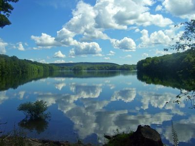
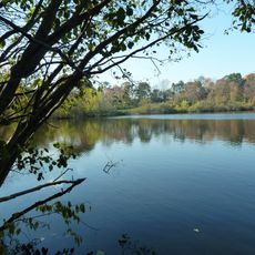
Bog Brook Reservoir, body of water

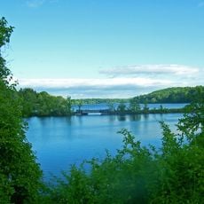
Bog Brook Reservoir is a water storage facility in Putnam County, New York, created by damming the Bog Brook stream. The water is held in a basin averaging 10 meters (34 feet) deep and connected via a brick-lined tunnel to the nearby East Branch Reservoir.

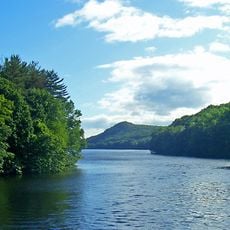
The reservoir was completed in 1892 as part of a larger water supply project for New York City. Its construction followed safety concerns that led engineers to build multiple smaller dams higher in the watershed instead of a single large dam.

The name comes from the small Bog Brook stream that feeds the reservoir. The quiet, forested landscape around it reflects how water and nature shape daily life in this rural part of the region.

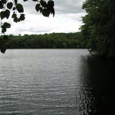
The reservoir is typically not open to the public to protect water quality, but the surrounding area offers nature observation from nearby roads. The best time to visit is during milder seasons when trails are drier and wildlife is more active.

The reservoir contains two small islands that are the only pieces of land on the water not connected to the shore. These rare natural features formed from the valley shape and are visible from a distance.

The community of curious travelers

AroundUs brings together thousands of curated places, local tips, and hidden gems, enriched daily by 60,000 contributors worldwide.

Start exploring
Location
GPS coordinates
41.41567,-73.58581
Latest update
February 7, 2026 11:40
Around this place
Wonder Lake State Park
United States of America

Wonder Lake State Park

10.3 km
The Summit at Danbury
United States of America

The Summit at Danbury

6 km
Titicus Reservoir
United States of America

Titicus Reservoir

9.8 km
East Branch Reservoir
United States of America

East Branch Reservoir

2.1 km
Main Street Historic District
United States of America

Main Street Historic District

11.3 km
Brewster High School
United States of America

Brewster High School

3.3 km
West Branch Reservoir
United States of America

West Branch Reservoir

9.6 km
Tarrywile
United States of America

Tarrywile

11.8 km
Baxter Preserve
United States of America

Baxter Preserve

8.6 km
Gerard Crane House
United States of America

Gerard Crane House

11.2 km
New Kursk-Root Icon Hermitage
United States of America

New Kursk-Root Icon Hermitage

11.4 km
Hammond Museum and Japanese Stroll Garden
United States of America

Hammond Museum and Japanese Stroll Garden

9.3 km
Kohanza Reservoir
United States of America

Kohanza Reservoir

7.8 km
Reed Memorial Library
United States of America

Reed Memorial Library

7.7 km
John Rider House
United States of America

John Rider House

12 km
Walter Brewster House
United States of America

Walter Brewster House

3.4 km
Ball and Roller Bearing Company
United States of America

Ball and Roller Bearing Company

11.3 km
Joseph Purdy Homestead
United States of America

Joseph Purdy Homestead

11.3 km
Putnam County Courthouse
United States of America

Putnam County Courthouse

7.8 km
P. Robinson Fur Cutting Company
United States of America

P. Robinson Fur Cutting Company

10.5 km
North Salem Town Hall
United States of America

North Salem Town Hall

9.7 km
Old Southeast Town Hall
United States of America

Old Southeast Town Hall

3.8 km
Cosier-Murphy House
United States of America

Cosier-Murphy House

11.1 km
First National Bank of Brewster
United States of America

First National Bank of Brewster

3.7 km
Williams House
United States of America

Williams House

9 km
Danbury Railway Museum
United States of America

Danbury Railway Museum

11.5 km
Octagon House
United States of America

Octagon House

10.9 km
Middle Branch Reservoir
United States of America

Middle Branch Reservoir

6 km
Show the full map
« Bog Brook Reservoir - body of water » is provided by Around Us (aroundus.com). Images and texts are derived from Wikimedia project under a Creative Commons license. You are allowed to copy, distribute, and modify copies of this page, under the conditions set by the license, as long as this note is clearly visible.

Discover hidden gems everywhere you go!

From secret cafés to breathtaking viewpoints, skip the crowded tourist spots and find places that match your style. Our app makes it easy with voice search, smart filtering, route optimization, and insider tips from travelers worldwide. Download now for the complete mobile experience.

Around Us App Screenshot

A unique approach to discovering new places

Le Figaro

All the places worth exploring

France Info

A tailor-made excursion in just a few clicks

20 Minutes

Around Us
Travel Guide & Maps
Download

Send to your phone

QR Code
1

Open the camera app on your mobile.

2

Point at the QR code with your camera. A notification will appear.

3

Tap the notification to open the link.