Enable Location

We need your location to show you interesting places around you

Discover nearby places

Find interesting locations and hidden gems around you

Precise directions

Get accurate directions and distances to places

Your location is never shared with other users. It's only used when you tap the location button.

Log in to your account

Start exploring — it's free

Trusted by 62,479 travelers worldwide

Continue with Google
Continue with Apple
or

We will send you a code to connect

By continuing, you accept our Terms and Conditions and our Privacy Policy

Check your inbox

We've sent a pincode in your inbox. Please enter the code below.

Kohanza Reservoir

Kohanza Reservoir, stuwmeer in de Verenigde Staten

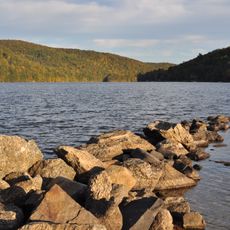
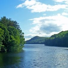
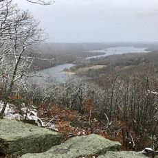
Kohanza Reservoir is a water body in Connecticut built in 1866 to supply water to Danbury's hat factories. The area now consists of two separate lakes, Upper Kohanza Lake and Lower Kohanza Lake, located in a valley accessible by local roads.

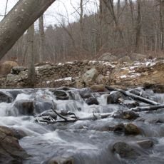
The original reservoir was built in 1866 as part of the area's industrial infrastructure. On January 31, 1869, a catastrophic dam failure released ice and water that surged into Danbury, killing eleven people and destroying multiple structures.

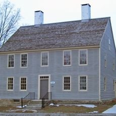
The reservoir was tied to Danbury's hat manufacturing industry, which required large amounts of water for production. Today the lakes serve as a reminder of that industrial past and how the town developed around its water sources.

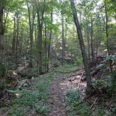
The location is easily reached by local roads and offers open spaces for walking and relaxation. The lakes provide good access for pedestrians and are open year-round, though warmer months offer the most comfortable visiting conditions.

The dam failure of 1869 was one of the region's worst disasters and occurred in less than half an hour. The event led to new safety standards for dam construction throughout the area and demonstrated the raw power of water.

The community of curious travelers

AroundUs brings together thousands of curated places, local tips, and hidden gems, enriched daily by 60,000 contributors worldwide.

Start exploring
Location
GPS coordinates
41.42340,-73.49350
Latest update
February 9, 2026 08:19
Around this place
Hearthstone Castle
United States of America

Hearthstone Castle

6.3 km
The Summit at Danbury
United States of America

The Summit at Danbury

5.5 km
Squantz Pond State Park
United States of America

Squantz Pond State Park

9.8 km
East Branch Reservoir
United States of America

East Branch Reservoir

8.7 km
Main Street Historic District
United States of America

Main Street Historic District

4.7 km
Bog Brook Reservoir
United States of America

Bog Brook Reservoir

7.8 km
Brewster High School
United States of America

Brewster High School

9.4 km
Charles Ives House
United States of America

Charles Ives House

6.2 km
Tarrywile
United States of America

Tarrywile

6 km
Danbury Museum and Historical Society
United States of America

Danbury Museum and Historical Society

5.5 km
Seth Low Pierrepont State Park Reserve
United States of America

Seth Low Pierrepont State Park Reserve

11 km
Pootatuck State Forest
United States of America

Pootatuck State Forest

10.2 km
Wooster Mountain State Park
United States of America

Wooster Mountain State Park

8.3 km
John Rider House
United States of America

John Rider House

5.5 km
Bennett's Pond State Park
United States of America

Bennett's Pond State Park

10.6 km
Walter Brewster House
United States of America

Walter Brewster House

10.7 km
Ball and Roller Bearing Company
United States of America

Ball and Roller Bearing Company

4.4 km
Brookfield Center Historic District
United States of America

Brookfield Center Historic District

10.1 km
Greenwood Avenue Historic District
United States of America

Greenwood Avenue Historic District

8.9 km
P. Robinson Fur Cutting Company
United States of America

P. Robinson Fur Cutting Company

4.4 km
Joseph W. Pepin Memorial Building
United States of America

Joseph W. Pepin Memorial Building

5 km
Old Southeast Town Hall
United States of America

Old Southeast Town Hall

10.9 km
Seth Seelye House
United States of America

Seth Seelye House

8.8 km
Cosier-Murphy House
United States of America

Cosier-Murphy House

5.4 km
Rev. John Ely House
United States of America

Rev. John Ely House

9.2 km
Williams House
United States of America

Williams House

3.6 km
Danbury Railway Museum
United States of America

Danbury Railway Museum

4.6 km
Octagon House
United States of America

Octagon House

4.3 km
Show the full map
« Kohanza Reservoir - stuwmeer in de Verenigde Staten » is provided by Around Us (aroundus.com). Images and texts are derived from Wikimedia project under a Creative Commons license. You are allowed to copy, distribute, and modify copies of this page, under the conditions set by the license, as long as this note is clearly visible.

Discover hidden gems everywhere you go!

From secret cafés to breathtaking viewpoints, skip the crowded tourist spots and find places that match your style. Our app makes it easy with voice search, smart filtering, route optimization, and insider tips from travelers worldwide. Download now for the complete mobile experience.

Around Us App Screenshot

A unique approach to discovering new places

Le Figaro

All the places worth exploring

France Info

A tailor-made excursion in just a few clicks

20 Minutes

Around Us
Travel Guide & Maps
Download

Send to your phone

QR Code
1

Open the camera app on your mobile.

2

Point at the QR code with your camera. A notification will appear.

3

Tap the notification to open the link.