Enable Location

We need your location to show you interesting places around you

Discover nearby places

Find interesting locations and hidden gems around you

Precise directions

Get accurate directions and distances to places

Your location is never shared with other users. It's only used when you tap the location button.

Dearborn School

Log in to your account

Start exploring — it's free

Trusted by 62,535 travelers worldwide

Continue with Google
Continue with Apple
or

We will send you a code to connect

By continuing, you accept our Terms and Conditions and our Privacy Policy

Check your inbox

We've sent a pincode in your inbox. Please enter the code below.

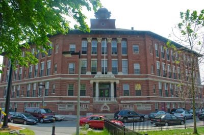
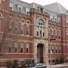
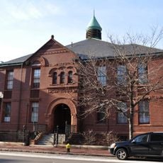
Dearborn School, in Boston, Massachusetts

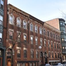
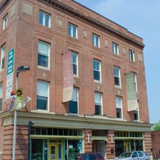
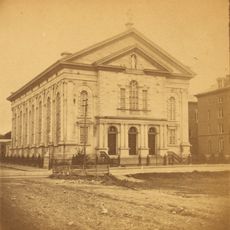
Dearborn School is a three-story brick building constructed in 1905 and designed in the Beaux Arts style by architect Edwin James Lewis Jr. The structure features red brick walls, tall windows, decorative stone details, and symmetrical classical proportions characteristic of important public buildings from that era.

The school was built in 1905 and named after Henry A. S. Dearborn, a former Boston mayor, serving as an educational center for neighborhood children until the 1980s. It remains the only building left standing from a major urban redevelopment project that transformed the area around 1950.

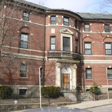
The school originally served as a vocational training center for young women and became deeply connected to the African American community and civil rights movements in Boston. Its presence in Roxbury reflects the neighborhood's identity as a center for education and social progress throughout the 20th century.

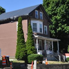
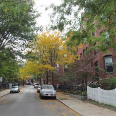
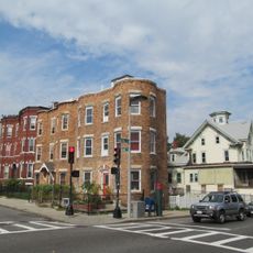
The building is located on Ambrose Street in Roxbury and can be viewed from the street since it has been converted to residential use. A walking tour of the neighborhood is the best way to appreciate the historic architecture and see how it fits into the surrounding area.

The school is the sole surviving structure from a major urban redevelopment project in the 1950s and was added to the National Register of Historic Places in 2000. Notably, artist Lois Mailou Jones received her early art education here and went on to become a renowned African American painter.

The community of curious travelers

AroundUs brings together thousands of curated places, local tips, and hidden gems, enriched daily by 60,000 contributors worldwide.

Start exploring
Location
GPS coordinates
42.32944,-71.07833
Latest update
February 9, 2026 07:42
Around this place
Roxbury Highlands Historic District
United States of America

Roxbury Highlands Historic District

1.1 km
National Emerging Infectious Diseases Laboratories
United States of America

National Emerging Infectious Diseases Laboratories

1.1 km
1767 Milestones
United States of America

1767 Milestones

1.1 km
United States of America

Hotel Alexandra

800 m
Interdisciplinary Science and Engineering Complex
United States of America

Interdisciplinary Science and Engineering Complex

1.2 km
Malcolm X—Ella Little-Collins House
United States of America

Malcolm X—Ella Little-Collins House

1.1 km
Shirley-Eustis House
United States of America

Shirley-Eustis House

833 m
Roxbury Heritage State Park
United States of America

Roxbury Heritage State Park

1 km
Lower Roxbury Historic District
United States of America

Lower Roxbury Historic District

1 km
St. Joseph Catholic Church
United States of America

St. Joseph Catholic Church

993 m
Hibernian Hall
United States of America

Hibernian Hall

355 m
Twelfth Baptist Church, Boston
United States of America

Twelfth Baptist Church, Boston

592 m
Eliot Burying Ground
United States of America

Eliot Burying Ground

407 m
Roxbury Presbyterian Church
United States of America

Roxbury Presbyterian Church

1.2 km
Victoria's Diner
United States of America

Victoria's Diner

987 m
Frederick Douglass Square Historic District
United States of America

Frederick Douglass Square Historic District

871 m
John Eliot Square District
United States of America

John Eliot Square District

1 km
Dudley Station Historic District
United States of America

Dudley Station Historic District

507 m
Mount Pleasant Historic District
United States of America

Mount Pleasant Historic District

403 m
Moreland Street Historic District
United States of America

Moreland Street Historic District

664 m
Dillaway School
United States of America

Dillaway School

737 m
Goldsmith Block
United States of America

Goldsmith Block

552 m
Frances and Isabella Apartments
United States of America

Frances and Isabella Apartments

656 m
Governor Shirley Square Historic District
United States of America

Governor Shirley Square Historic District

474 m
Greenville Street Historic District
United States of America

Greenville Street Historic District

277 m
Joshua Bates School
United States of America

Joshua Bates School

1.1 km
Roxbury Parting Stone
United States of America

Roxbury Parting Stone

1.1 km
Church of the Immaculate Conception
United States of America

Church of the Immaculate Conception

931 m
Show the full map
« Dearborn School - in Boston, Massachusetts » is provided by Around Us (aroundus.com). Images and texts are derived from Wikimedia project under a Creative Commons license. You are allowed to copy, distribute, and modify copies of this page, under the conditions set by the license, as long as this note is clearly visible.

Discover hidden gems everywhere you go!

From secret cafés to breathtaking viewpoints, skip the crowded tourist spots and find places that match your style. Our app makes it easy with voice search, smart filtering, route optimization, and insider tips from travelers worldwide. Download now for the complete mobile experience.

Around Us App Screenshot

A unique approach to discovering new places

Le Figaro

All the places worth exploring

France Info

A tailor-made excursion in just a few clicks

20 Minutes

Around Us
Travel Guide & Maps
Download

Send to your phone

QR Code
1

Open the camera app on your mobile.

2

Point at the QR code with your camera. A notification will appear.

3

Tap the notification to open the link.