Enable Location

We need your location to show you interesting places around you

Discover nearby places

Find interesting locations and hidden gems around you

Precise directions

Get accurate directions and distances to places

Your location is never shared with other users. It's only used when you tap the location button.

Diamond Shoal Light

Log in to your account

Start exploring — it's free

Trusted by 62,487 travelers worldwide

Continue with Google
Continue with Apple
or

We will send you a code to connect

By continuing, you accept our Terms and Conditions and our Privacy Policy

Check your inbox

We've sent a pincode in your inbox. Please enter the code below.

Diamond Shoal Light

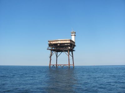
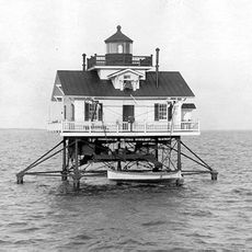
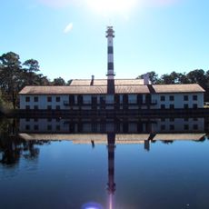
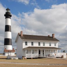
Diamond Shoal Light, Offshore lighthouse at Diamond Shoals, North Carolina, US.

Diamond Shoal Light is an offshore lighthouse at Diamond Shoals in North Carolina, built on four black steel piles with a white square platform at its top. The structure rises approximately 120 feet (37 meters) above the water and was specifically designed to guide ships through this dangerous stretch of ocean.

The lighthouse began operating in 1966 and replaced multiple lightships that had served this area since 1824. Its construction using prefabricated steel modules represented an innovative solution for this exposed location.

This navigational beacon represents the maritime legacy of North Carolina, marking the location where numerous vessels met their fate in treacherous waters.

The structure has been inactive since 2001 and cannot be visited up close, but it remains visible from shore and from boats on the water. The best views come from the mainland beaches or during water excursions in the area.

This structure was an early example of a Texas Tower, a modern steel platform design created specifically for offshore locations like this one. The system made it possible to place a lighthouse where traditional tower construction was impossible.

The community of curious travelers

AroundUs brings together thousands of curated places, local tips, and hidden gems, enriched daily by 60,000 contributors worldwide.

Start exploring
Location
GPS coordinates
35.15333,-75.29667
Latest update
December 10, 2025 15:55
Around this place
Cape Hatteras Lighthouse
United States of America

Cape Hatteras Lighthouse

23.7 km
Bodie Island Light
United States of America

Bodie Island Light

77.9 km
Portsmouth
United States of America

Portsmouth

70.5 km
Pea Island National Wildlife Refuge
United States of America

Pea Island National Wildlife Refuge

59.3 km
Ocracoke Light
United States of America

Ocracoke Light

63 km
Graveyard of the Atlantic Museum
United States of America

Graveyard of the Atlantic Museum

37.5 km
Rodanthe Bridge
United States of America

Rodanthe Bridge

53.5 km
Chicamacomico Life-Saving Station
United States of America

Chicamacomico Life-Saving Station

51.5 km
Coquina Beach
United States of America

Coquina Beach

79.5 km
Roanoke Marshes Light
United States of America

Roanoke Marshes Light

81.9 km
United States of America

Naval Facility Cape Hatteras

23.6 km
Salvo Post Office
United States of America

Salvo Post Office

46 km
Lake Mattamuskeet Pump Station
United States of America

Lake Mattamuskeet Pump Station

86.4 km
Bodie Island Lifesaving and Coast Guard Station
United States of America

Bodie Island Lifesaving and Coast Guard Station

78.9 km
Inkwell
United States of America

Inkwell

78 km
Hatteras Weather Bureau Station
United States of America

Hatteras Weather Bureau Station

36.6 km
Rasmus Midgett House
United States of America

Rasmus Midgett House

46.4 km
Ellsworth and Lovie Ballance House
United States of America

Ellsworth and Lovie Ballance House

36.3 km
Frisco Mini-Golf and Go Carts
United States of America

Frisco Mini-Golf and Go Carts

29 km
Bodie Island Light Station
United States of America

Bodie Island Light Station

77.9 km
Bodie Island Visitor Center
United States of America

Bodie Island Visitor Center

77.9 km
Rodanthe Public Beach Access
United States of America

Rodanthe Public Beach Access

51.4 km
North Pond Wildlife Trail
United States of America

North Pond Wildlife Trail

65.1 km
Coquina Beach
United States of America

Coquina Beach

79.4 km
Pea Island National Wildlife Refuge Visitor Center
United States of America

Pea Island National Wildlife Refuge Visitor Center

65.2 km
Bald Beach
United States of America

Bald Beach

33.6 km
Pea Island Beach
United States of America

Pea Island Beach

65.6 km
Sand Island
United States of America

Sand Island

85.5 km
Show the full map
« Diamond Shoal Light - Offshore lighthouse at Diamond Shoals, North Carolina, US » is provided by Around Us (aroundus.com). Images and texts are derived from Wikimedia project under a Creative Commons license. You are allowed to copy, distribute, and modify copies of this page, under the conditions set by the license, as long as this note is clearly visible.

Discover hidden gems everywhere you go!

From secret cafés to breathtaking viewpoints, skip the crowded tourist spots and find places that match your style. Our app makes it easy with voice search, smart filtering, route optimization, and insider tips from travelers worldwide. Download now for the complete mobile experience.

Around Us App Screenshot

A unique approach to discovering new places

Le Figaro

All the places worth exploring

France Info

A tailor-made excursion in just a few clicks

20 Minutes

Around Us
Travel Guide & Maps
Download

Send to your phone

QR Code
1

Open the camera app on your mobile.

2

Point at the QR code with your camera. A notification will appear.

3

Tap the notification to open the link.