Enable Location

We need your location to show you interesting places around you

Discover nearby places

Find interesting locations and hidden gems around you

Precise directions

Get accurate directions and distances to places

Your location is never shared with other users. It's only used when you tap the location button.

Rodanthe Bridge

Log in to your account

Start exploring — it's free

Trusted by 61,320 travelers worldwide

Continue with Google
Continue with Apple
or

We will send you a code to connect

By continuing, you accept our Terms and Conditions and our Privacy Policy

Check your inbox

We've sent a pincode in your inbox. Please enter the code below.

Rodanthe Bridge

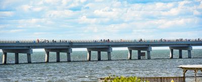
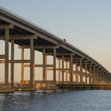
Rodanthe Bridge, Transportation bridge in Rodanthe, North Carolina, United States

Description

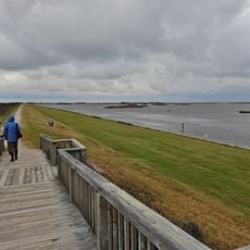
Rodanthe Bridge is a steel structure spanning approximately 2.4 miles across Pamlico Sound, connecting the southern portion of Pea Island National Wildlife Refuge to northern Rodanthe. It was constructed to replace a vulnerable coastal highway that regularly experienced flooding and erosion damage.

History

Construction of this major infrastructure project began in 2018 in response to the repeated failure of the original highway route during storms. The bridge opened to traffic in 2022 after final details were completed.

Culture

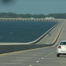
The bridge serves as a vital link between island communities and enables residents to maintain their traditional way of life without disrupting the wildlife refuge nearby. Visitors crossing it see how the islands depend on this connection to stay vibrant and functioning.

Practical

The bridge is freely accessible and follows a straightforward driving route across the water. Drive carefully and stay focused, especially during windy conditions or poor weather, which commonly occur on this exposed section.

Did you know?

The bridge follows an unusual curved path that sweeps westward before returning eastward, specifically designed to avoid erosion zones in the sound. This creative engineering approach demonstrates how builders worked around natural hazards rather than through them.

GPS coordinates
35.61000,-75.48000
Latest update
December 10, 2025 16:30

AroundUs brings together thousands of curated places, local tips, and hidden gems, enriched daily by 60,000 contributors worldwide. Discover all places nearby (United States of America).

Around this place
Cape Hatteras Lighthouse
United States of America

Cape Hatteras Lighthouse

40.3 km
Bodie Island Light
United States of America

Bodie Island Light

24.4 km
Alligator River National Wildlife Refuge
United States of America

Alligator River National Wildlife Refuge

38.6 km
Virginia Dare Memorial Bridge
United States of America

Virginia Dare Memorial Bridge

38.4 km
North Carolina Aquariums
United States of America

North Carolina Aquariums

39.8 km
Pea Island National Wildlife Refuge
United States of America

Pea Island National Wildlife Refuge

5.8 km
Chicamacomico Life-Saving Station
United States of America

Chicamacomico Life-Saving Station

2.2 km
Coquina Beach
United States of America

Coquina Beach

26 km
Roanoke Island Festival Park
United States of America

Roanoke Island Festival Park

37.6 km
Roanoke Marshes Light
United States of America

Roanoke Marshes Light

30 km
United States of America

Naval Facility Cape Hatteras

39.4 km
Sea Foam Motel
United States of America

Sea Foam Motel

35 km
Salvo Post Office
United States of America

Salvo Post Office

7.8 km
Bodie Island Lifesaving and Coast Guard Station
United States of America

Bodie Island Lifesaving and Coast Guard Station

25.4 km
George Washington Creef House
United States of America

George Washington Creef House

37.4 km
University of North Carolina - Coastal Studies Institute
United States of America

University of North Carolina - Coastal Studies Institute

33.6 km
Rasmus Midgett House
United States of America

Rasmus Midgett House

7.3 km
John T. Daniels House
United States of America

John T. Daniels House

37.8 km
Theodore S. Meekins House
United States of America

Theodore S. Meekins House

37.5 km
Washington Baum Bridge
United States of America

Washington Baum Bridge

34.5 km
Bodie Island Light Station
United States of America

Bodie Island Light Station

24.4 km
Bodie Island Visitor Center
United States of America

Bodie Island Visitor Center

24.4 km
Rodanthe Public Beach Access
United States of America

Rodanthe Public Beach Access

2.3 km
North Pond Wildlife Trail
United States of America

North Pond Wildlife Trail

11.9 km
Coquina Beach
United States of America

Coquina Beach

25.9 km
Pea Island National Wildlife Refuge Visitor Center
United States of America

Pea Island National Wildlife Refuge Visitor Center

11.9 km
Bald Beach
United States of America

Bald Beach

21.9 km
Pea Island Beach
United States of America

Pea Island Beach

12.3 km
Show the full map
« Rodanthe Bridge - Transportation bridge in Rodanthe, North Carolina, United States » is provided by Around Us (aroundus.com). Images and texts are derived from Wikimedia project under a Creative Commons license. You are allowed to copy, distribute, and modify copies of this page, under the conditions set by the license, as long as this note is clearly visible.

Discover hidden gems everywhere you go!

From secret cafés to breathtaking viewpoints, skip the crowded tourist spots and find places that match your style. Our app makes it easy with voice search, smart filtering, route optimization, and insider tips from travelers worldwide. Download now for the complete mobile experience.

Around Us App Screenshot

A unique approach to discovering new places

Le Figaro

All the places worth exploring

France Info

A tailor-made excursion in just a few clicks

20 Minutes

Around Us
Travel Guide & Maps
Download

Send to your phone

QR Code
1

Open the camera app on your mobile.

2

Point at the QR code with your camera. A notification will appear.

3

Tap the notification to open the link.