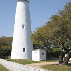
Cape Hatteras Lighthouse, Maritime navigation lighthouse in Buxton, United States
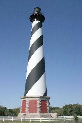
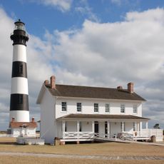
Cape Hatteras Lighthouse is a navigation tower built from brick and reinforced concrete on the Atlantic coast of North Carolina. The structure displays spiraling black and white stripes that rise roughly 60 meters (198 feet) from base to lantern room.
The first tower rose in 1803 at roughly 27 meters (90 feet) from sandstone but proved too short for navigation purposes. The current construction was completed in 1870 and has operated ever since.
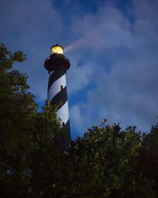
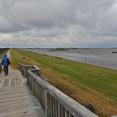
Sailors once relied on the rotating beam to navigate through fog and storms along this dangerous stretch of coast. Local fishing crews still regard the tower as a symbol of safe passage through waters where countless ships met their end.
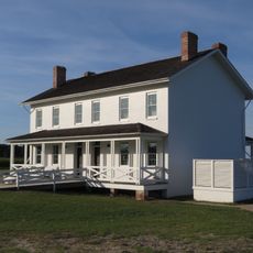
Restoration work keeps the interior closed until 2026, though the grounds remain open for visits. The site sits on the Outer Banks in Buxton, reachable by coastal roads from Nags Head or Ocracoke.
Engineers relocated the entire structure over 880 meters inland during 1999 to protect it from coastal erosion. The move took 23 days and used hydraulic jacks along with steel rails to keep the building intact.
Location: Dare County
Inception: 1870
Made from material: brick, reinforced concrete
GPS coordinates: 35.25056,-75.52881
Latest update: December 5, 2025 22:25
Historic lighthouses around the world tell the story of the way ships have been guided for hundreds of years. From the rocky coast of Norway to the cliffs of the Pacific, these towers have helped sailors since ancient times. The Tower of Hercules in Spain has been shining over the sea since the second century. The lighthouse at Cape Hatteras in North Carolina watches over the dangerous sands of the Atlantic with its easy-to-spot black and white stripes. Each lighthouse shows the time and place it was built. Some sit on high cliffs exposed to the wind, like Heceta Head in Oregon, whose light reaches out over the ocean. Others mark important points, like Fanad Head in Ireland, which shows where a fjord begins, or Jeffreys Hook in New York, under the George Washington Bridge. These structures show how builders used their skills to work with the land, the weather, and the materials they had nearby. Today, these towers still light the sea routes and attract visitors curious about their design and history. Whether it’s the limestone at Cape Otway in Australia or the bricks at Cape Bojeador in the Philippines, each lighthouse remains a landmark on the coast and a living link to the sea’s traditions.
Lighthouses tell the history of sailing with their shapes and building styles. Some go back to Roman times, like the Tower of Hercules in Galicia, a structure from the second century still working today. Others are from the Middle Ages, such as the Hook Lighthouse in Ireland, with its six-meter-thick stone walls. Later times left marks on the coast as well. The Kõpu Lighthouse in Estonia was built in 1531, and many from the 19th century can be seen along North American shores. These towers stand in very different places. The Hatteras Lighthouse is easy to spot with its black and white spiral stripes on the North Carolina coast. Peggy's Point rises over granite rocks in Nova Scotia. Further south, the Eclaireurs Lighthouse watches over a small island in the Beagle Channel, near Ushuaia. In Europe, the Lindau Lighthouse has a clock you can see from Lake Constance, while Fanad Head marks the entrance to an Irish fjord. Each one adapts to local conditions, whether it's cliffs, reefs, or harbor entrances.
Portsmouth
52.5 km
Alligator River National Wildlife Refuge
66.1 km
Diamond Shoal Light
23.7 km
Pea Island National Wildlife Refuge
45.9 km
Ocracoke Light
44.5 km
Graveyard of the Atlantic Museum
16.7 km
Rodanthe Bridge
40.3 km
Chicamacomico Life-Saving Station
38.8 km
Coquina Beach
65.1 km
Mattamuskeet National Wildlife Refuge
67 km
Roanoke Marshes Light
64.3 km
Naval Facility Cape Hatteras
1 km
Salvo Post Office
32.6 km
Lake Mattamuskeet Pump Station
62.8 km
Bodie Island Lifesaving and Coast Guard Station
64.5 km
Inkwell
54.3 km
Hatteras Weather Bureau Station
15.1 km
Rasmus Midgett House
33.2 km
Ellsworth and Lovie Ballance House
14.7 km
Frisco Mini-Golf and Go Carts
5.6 km
Bodie Island Light Station
63.3 km
Bodie Island Visitor Center
63.3 km
Rodanthe Public Beach Access
38.7 km
North Pond Wildlife Trail
51.9 km
Coquina Beach
65 km
Pea Island National Wildlife Refuge Visitor Center
52 km
Bald Beach
18.6 km
Pea Island Beach
52.4 kmVisited this place? Tap the stars to rate it and share your experience / photos with the community! Try now! You can cancel it anytime.
Discover hidden gems everywhere you go!
From secret cafés to breathtaking viewpoints, skip the crowded tourist spots and find places that match your style. Our app makes it easy with voice search, smart filtering, route optimization, and insider tips from travelers worldwide. Download now for the complete mobile experience.
A unique approach to discovering new places❞
— Le Figaro
All the places worth exploring❞
— France Info
A tailor-made excursion in just a few clicks❞
— 20 Minutes