Historic lighthouses: maritime architecture, navigation and history
Lighthouses tell the history of sailing with their shapes and building styles. Some go back to Roman times, like the Tower of Hercules in Galicia, a structure from the second century still working today. Others are from the Middle Ages, such as the Hook Lighthouse in Ireland, with its six-meter-thick stone walls. Later times left marks on the coast as well. The Kõpu Lighthouse in Estonia was built in 1531, and many from the 19th century can be seen along North American shores.
These towers stand in very different places. The Hatteras Lighthouse is easy to spot with its black and white spiral stripes on the North Carolina coast. Peggy's Point rises over granite rocks in Nova Scotia. Further south, the Eclaireurs Lighthouse watches over a small island in the Beagle Channel, near Ushuaia. In Europe, the Lindau Lighthouse has a clock you can see from Lake Constance, while Fanad Head marks the entrance to an Irish fjord. Each one adapts to local conditions, whether it's cliffs, reefs, or harbor entrances.
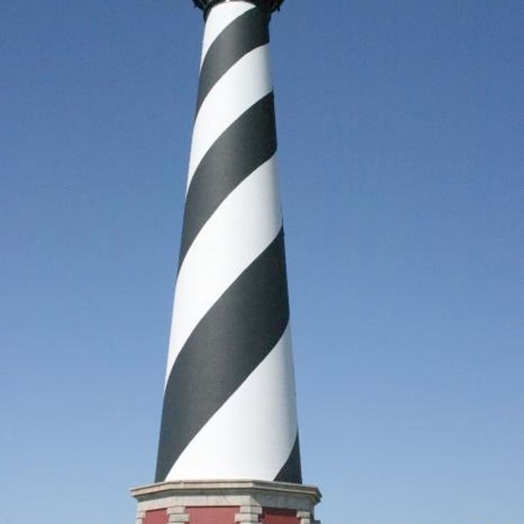
The lighthouse at Cape Hatteras was built in the mid-1800s along the sandy shores of North Carolina. The brick structure rises to about 200 feet (60 meters) and carries black and white spiral stripes that wind around its entire body. This pattern helped sailors identify the lighthouse from a distance, even during daylight. The coast here is known for its strong currents and shallow waters, which made the tower an important reference point for ships. In the 1990s the lighthouse was moved about half a mile inland to protect it from erosion. The beach around the structure now draws many visitors who climb the tower or simply enjoy the view of the Atlantic.
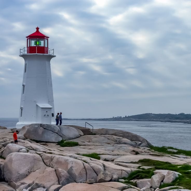
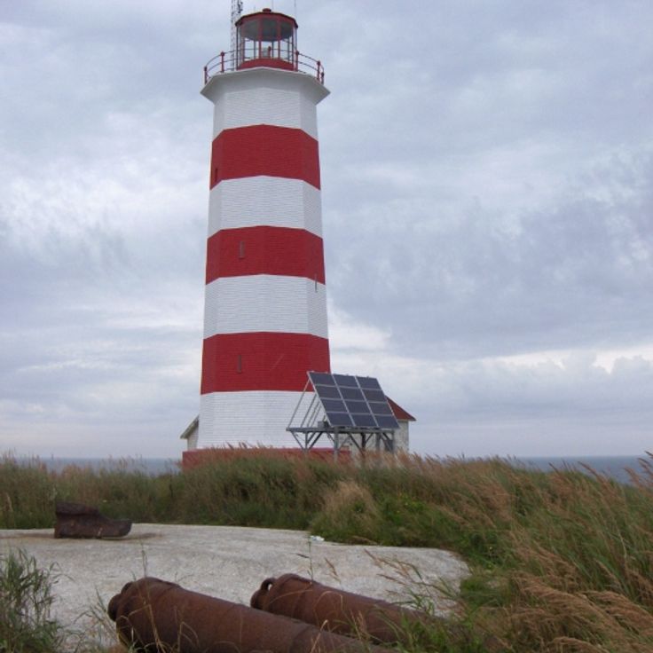
This lighthouse stands on bare granite that juts out from the Atlantic shoreline. Its red and white exterior sets itself against the stone, a contrast of smooth surfaces and rough rock. The tower itself sits low to the water, but the position alone is enough to guide ships. Around the base lie rugged boulders that meet the ocean in waves and spray. A narrow path leads to the door opening that faces inland. From the edge of the headland, you look out over open water that stretches to the horizon. Visitors who come here walk over the smooth worn rock surfaces and often pause to photograph the light or take in the view of the ocean.
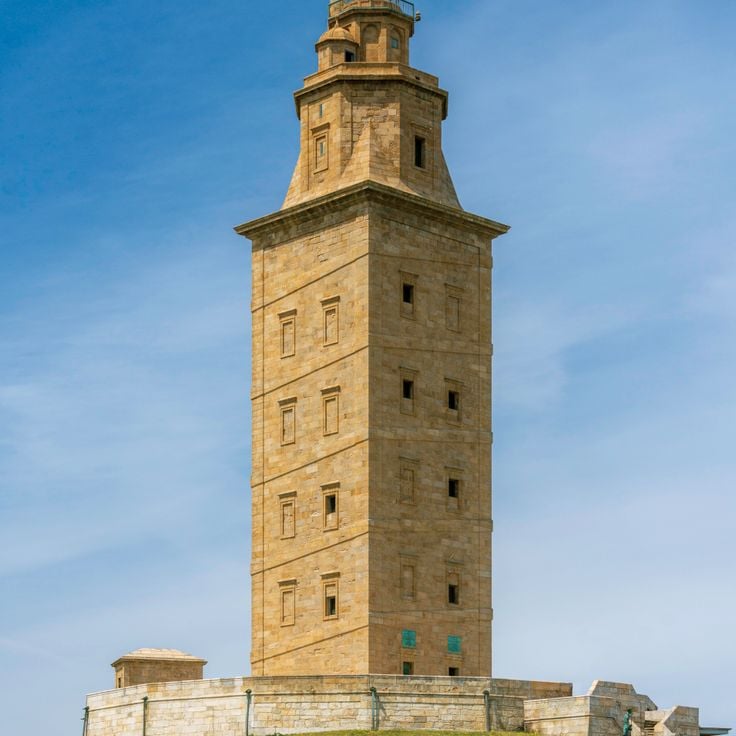
The Torre de Hércules is the oldest working lighthouse in the world. This Roman structure from the second century stands on a rocky headland in Galicia and has served as a marker for ships for almost two thousand years. The tower rises about one hundred eighty feet and was extensively restored in the eighteenth century, though its Roman inner core remains. You can climb the spiral staircase inside, passing thick stone walls that have withstood centuries of wind and Atlantic storms. From the top, there are wide views across the coast and open sea where Roman trading vessels once passed.
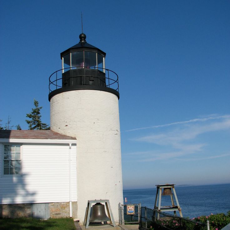
This red brick lighthouse has stood on the southern tip of Mount Desert Island since 1858, marking the entrance to Blue Hill Bay. The small keeper's house sits on a rise where granite cliffs drop toward the water. The tower itself measures about twenty six feet and carries a black lantern. On clear days you can see the hills along the coast and smaller islands in the water. Boats pass close to the rocks when entering the bay. The path to the base of the cliffs runs over uneven steps between pines and lichens growing on the granite. At high tide, waves hit the rocks directly, at low tide the sea pulls far back and exposes kelp and shells.
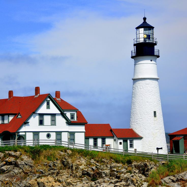
This lighthouse has stood on a rock above Casco Bay since 1791, warning ships of the dangerous coast. The stone walls rise from bare bedrock while waves break at the base. The tower marks the entrance to Portland and ranks among the oldest continuously operating lighthouses on the Atlantic seaboard. The white paint stands out against the gray rock, and the adjoining keeper's house sits behind low stone walls. On clear days you can see across the open bay to the offshore islands.
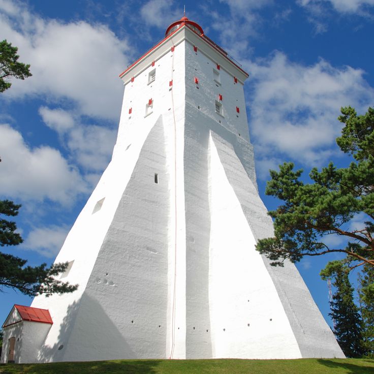
The Kõpu lighthouse has guided ships through the Gulf of Finland and the Baltic Sea since 1531. Its thick walls of limestone and fieldstone have withstood storms for nearly five centuries. The square tower rises from a wooded hill on Hiiumaa Island, standing above the surrounding landscape. From here, the view reaches far across open water where trade routes cross. The construction resembles a medieval fortress, with small windows and massive walls that originally served as protection against attacks. Inside, a narrow staircase winds upward to where keepers once tended the fire. Today this lighthouse continues to mark the coast for sailors traveling between Sweden, Finland and Estonia.
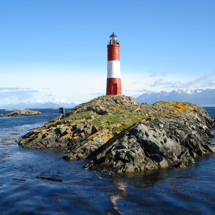
This red and white lighthouse stands on a small island in the Beagle Channel, showing the history of navigation at the southernmost point of the continent. Visible from the water, it marks the way through a remote region shaped by low rocks and cold currents. Its position makes it a reference point for boats passing through this narrow channel, where wind and waves present constant challenges.
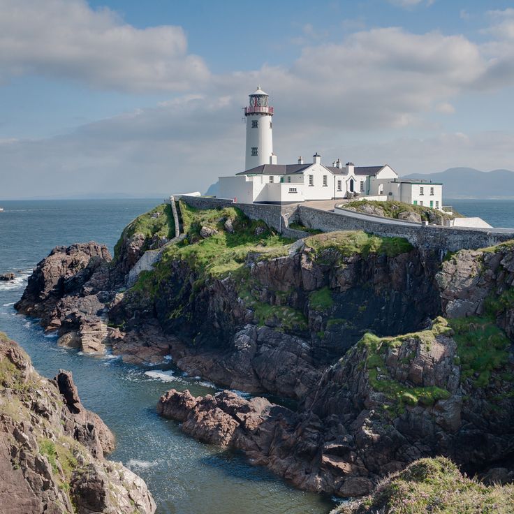
This lighthouse has marked the entrance to Lough Swilly since 1817 and stands on a cliff on the Fanad Peninsula. The white tower was built after several shipwrecks occurred in this region. The construction consists of thick stone walls that withstand the wind and storms that regularly sweep across the northern coast. A keeper's house from the same period stands beside the tower. From the cliff, the view opens onto the sea inlet and the surrounding hills. The path to the lighthouse leads through a landscape of grass and rocks where sheep graze. The light still turns today and sends its signal across the water.
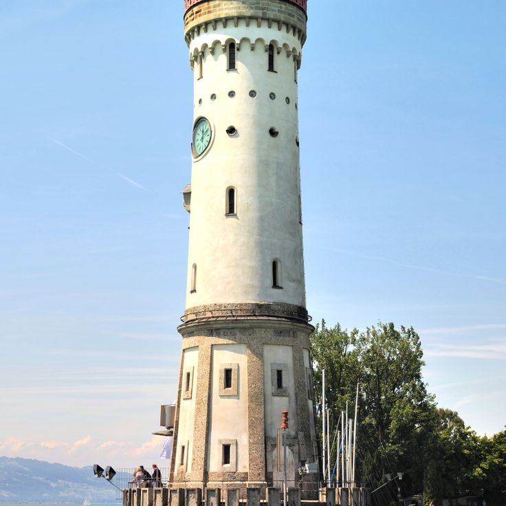
This lighthouse stands at the entrance to the harbor in Lindau and has carried a clock on its lake-facing side since it was built in the nineteenth century. The tower rises about one hundred feet, making it visible from across Lake Constance. The structure combines the function of maritime navigation with practical timekeeping for ships and people on the shore. Its position at the harbor entrance shows the importance of this point for navigation on the lake.
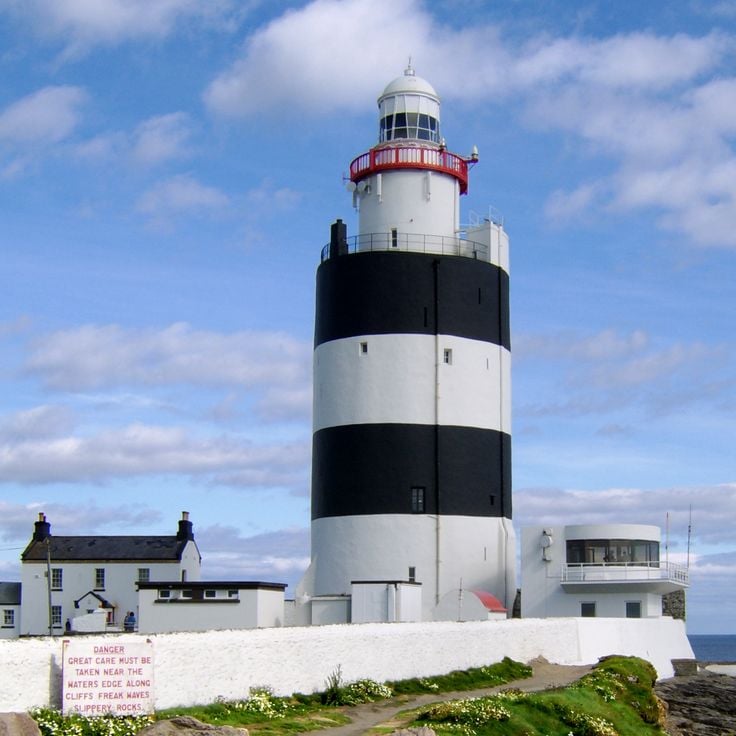
The Phare de Hook was built in medieval times and has stood at the tip of the peninsula in County Wexford ever since. Its stone walls reach a thickness of six meters and still carry the tower, which rises over several floors. The construction method matches the needs of a coast where wind and waves have beaten against the rock for centuries. Monks first maintained a beacon here before the tower took its present shape. From the outside, it shows a solid structure that carries little decoration and focuses entirely on its purpose. Inside, a spiral staircase leads up through the levels. Those who visit the Phare de Hook see one of the oldest working sea marks in Europe and learn how people in the Middle Ages tried to guide ships on their way.
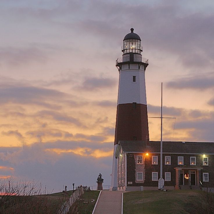
This lighthouse was completed in 1796 and stands as the first one built on Long Island. The structure rises from a rocky bluff at the easternmost point of the island, where the Atlantic meets the shore. The octagonal tower is made of sandstone and reaches about 110 feet (33 meters) in height, carrying its beacon for more than two centuries. Ocean waves have eroded the ground beneath the cliff over time, leading to the construction of stone walls for protection. From the top, you can see the open sea stretching to the horizon and the rocky coastline extending westward. The light has guided countless ships through the dangerous passage around the point. Wind shapes this place, and even on calm days the setting feels powerful.
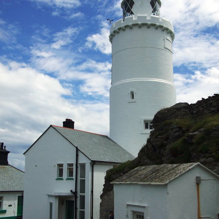
This lighthouse rises from a headland on the Devon coast, where rock drops sharply into the sea. The white tower stands clear against the sky, while water breaks on the rocks below. Built in the 1830s, the structure belongs to the long line of navigational aids that English engineers raised along dangerous coastlines during the nineteenth century. The Start Point lighthouse sits in a landscape that stretches between open sea and green hills, where paths run over the cliffs and the wind blows steadily.
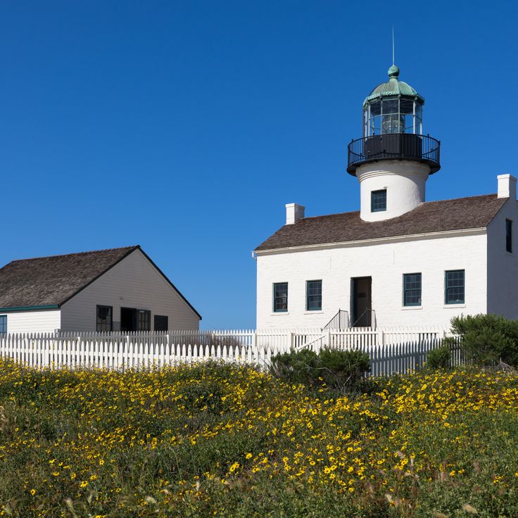
The Point Loma lighthouse has stood above the Pacific since 1855, marking the entrance to San Diego Bay. It sits on a hill more than a hundred meters above the water, where its light once guided ships along the coast. The keepers lived here with their families in rooms built into the tower structure. Later it was replaced by another lighthouse closer to sea level, because fog and clouds often blocked the beam. Today you can walk through the preserved rooms and see how life was for the people who ran this maritime station.
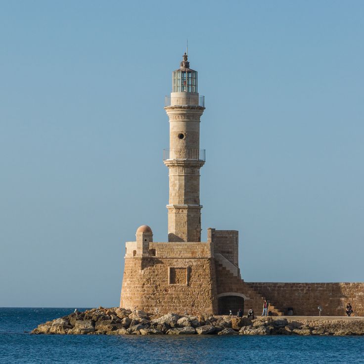
This lighthouse stands at the harbor entrance of Chania on foundations from the Venetian period. The Ottomans built the structure in the 16th century. Its shape recalls a slender tower mosque with a stone base and an octagonal upper section. The light shines over the breakwaters of the old harbor, where fishermen spread their nets and ferries dock. The stones show the different building phases this structure has gone through, while the houses of the Venetian old town line the harbor basin all around.
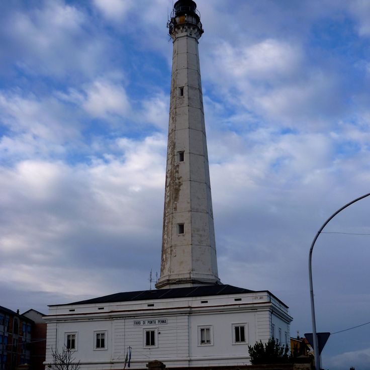
The Punta Penna lighthouse has stood on the Abruzzo coast since 1906, painted with red and white stripes that run the full height of the tower. This geometric pattern helped ships recognize the landmark along this stretch of the Adriatic. From ground level the tower appears tall and narrow against the sky. The structure is among the tallest lighthouses in the country and marks the entrance to the port of Vasto. Around the base the landscape is flat, with beaches and low vegetation that make the lighthouse seem even taller.
The Sambro Lighthouse has marked the entrance to Halifax harbor since 1758. The tower rises from a rocky stretch of coastline with stone walls that send red and white light across the water. Fishermen and merchant ships relied on this beacon in the eighteenth century when British colonial authorities ordered its construction. The thick walls have withstood storms and salt air for more than two centuries. Today the lighthouse still guides vessels through the waters off Nova Scotia while its form recalls the early days of organized navigation along this Atlantic coast.
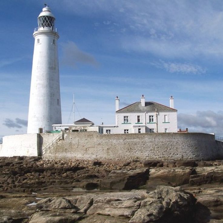
The lighthouse at St Mary's stands on a small island off the coast of Tyne and Wear, connected to the mainland by an eight hundred foot causeway that appears at low tide. This white tower belongs to a collection that traces the evolution of seafaring through its built landmarks. The structure sits between cliffs and tides, where water dictates the terms. When the tide retreats, you can walk across to the island. When it rises, only a boat will do. The plain form of this lighthouse shows how architecture adapts to the demands of the open sea without unnecessary ornament.
This tower has marked the entrance to the strait separating mainland Australia from Tasmania since the 1890s. The white structure rises about 110 feet (34 meters) above the Victorian coast and was built with brick. Ships used to fix their position from this point when traveling through the sometimes rough waters of Bass Strait. The building stands on a headland and remains visible from the sea. It reminds visitors how coastal navigation was organized in the late 19th century.
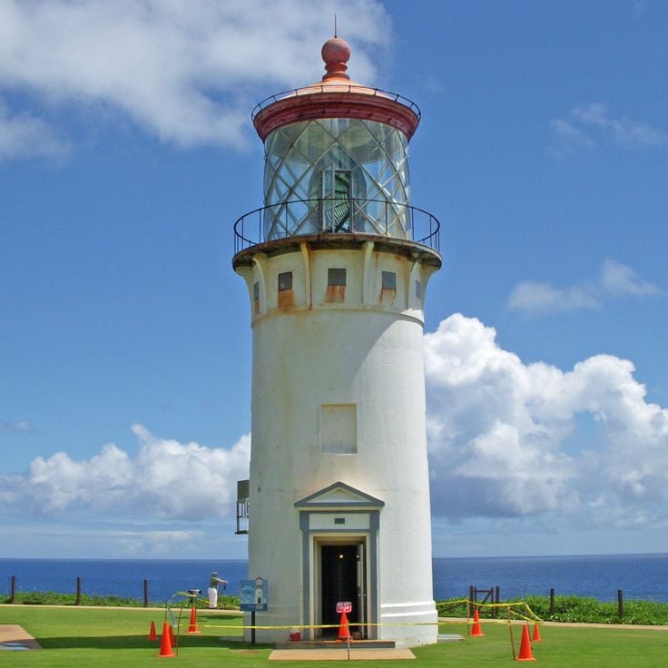
This lighthouse from 1913 stands on a cliff along the north coast and looks out over the Pacific. The location on Kauai shows how navigation in the early 20th century made the dangerous waters around the Hawaiian Islands safer. The tower belongs to the history of seafaring in the Pacific, where ships traveling between Asia and America needed guidance. From the cliff you can see how the ocean hits the rocks and shapes the coastline. The lighthouse reminds us that even remote islands were part of larger trade routes.
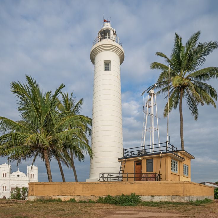
This white lighthouse from 1938 rises on the walls of an old Dutch fort, where the fortifications meet the Indian Ocean. The tower stands within the grounds of Galle Fort, an area that still carries traces of European colonial times. From the ramparts, you can look out over the sea, while the buildings of the fort cluster behind the thick stone walls. The lighthouse marks the tip of the peninsula, where ships have navigated the trade routes for centuries.
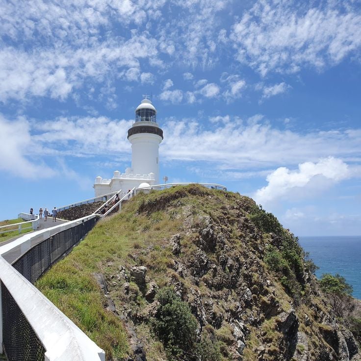
The Byron Bay Lighthouse was built in 1901 on a clifftop marking the easternmost point of the Australian mainland. This white navigation structure stands on a rocky promontory where the Pacific Ocean meets the coast of New South Wales. From here the view stretches across open water, while whales pass offshore during their migration. The surrounding land consists of grassland and low scrub that bends in the wind. A walking trail leads up from the visitor center to the tower, passing spots where dolphins sometimes appear in the water below. The lens inside continues to rotate, sending its signal across the sea. Hikers come here to feel the expanse and reach the point where Australia gives way to ocean.
This lighthouse from 1900 stands on top of a moving dune that threatens to swallow the structure, abandoned since 1968. The coast of Jutland changes its face through wind and waves, and the sand creeps higher up the walls year after year. The building used to sit farther from the sea, but erosion has worn down the cliff and pushed the dunes closer. Today only the upper part of the construction rises out of the sand. The surroundings feel bare and endless, with grass-covered slopes and the open horizon of the North Sea.
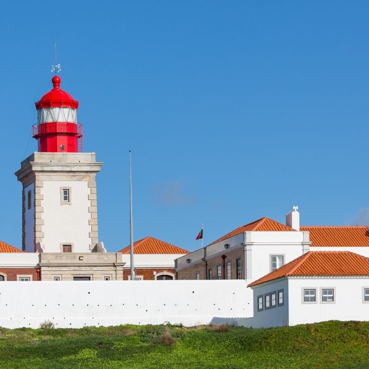
This lighthouse stands on a cliff above the Atlantic and marks the westernmost point of mainland Europe. Built in 1772, it sends its signal across the waves while the sea crashes against the rocks below. Its location makes it a reference point for ships sailing along the Portuguese coast, where the continent ends and the ocean begins.
The Phare des Poulains was built in 1868 on a rocky islet connected to Belle-Île-en-Mer by a narrow strip of land. The tower stands above the Brittany coast, where wind and tides constantly change the passage conditions. The ground around the lighthouse consists of sharp stones and low vegetation adapted to the salty climate. On calm days, the crossing to the island can be made on foot, while during storms the waves cut off the connection. The structure belongs to the maritime markers erected along the French Atlantic coast during the nineteenth century.
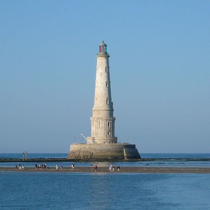
The Cordouan lighthouse was built between 1584 and 1611 and shows Renaissance construction with carved decorations and a royal chapel. The structure stands on a rocky island in the Gironde estuary and has served shipping for over four centuries. The chapel inside was an unusual element for a lighthouse and speaks to the importance given to this building. The stonework combines nautical function with formal architecture from the late sixteenth century.
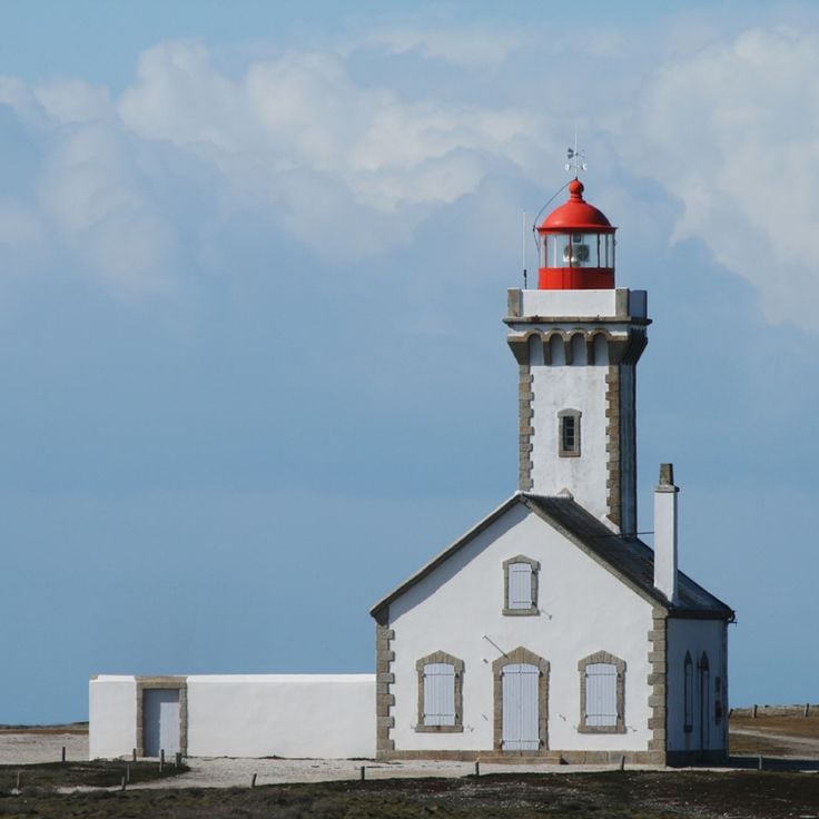
This lighthouse displays an octagonal design from 1918 and stands on the western tip of the peninsula above the fishing harbor. The eight-sided construction was a common form in maritime architecture at the time. From the harbor entrance, the white tower serves as a fixed reference point for fishing boats coming and going each day.
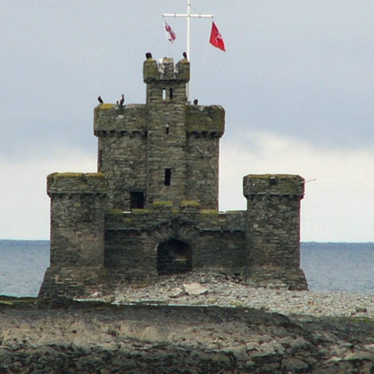
This stone tower from 1832 rises on a solitary rock in Douglas Bay and served as a refuge for shipwrecked sailors. The construction follows an old tradition of navigation aids that helped seafarers not only through light signals but also by offering a safe harbor after disaster. Its position on the rock shows how people in the nineteenth century tried to address the dangers of the Irish Sea. At low tide, the foundations emerge more clearly, while at high tide the water reaches up to the base. From the shore, the tower stands like a watchman over the water, a witness to the practical solutions that life by the sea demanded.
This tower from 1952 rises above the harbor and replaced the British colonial lighthouse destroyed during the war. The white structure marks the harbor entrance and stands where the earlier beacon once served. The building fits into a history that speaks of the end of colonial times and rebuilding after the war years.
The lighthouse has stood since 1880 on the coast of the Gaspé Peninsula, marking the entrance to the bay from the Gulf of Saint Lawrence. Its white tower rises above a point of land where wind and waves shape the shore. The structure was built to guide ships through this often foggy passage. The building shows the maritime construction methods of the 19th century in this region. From here you can look out over the expanse of water and watch how light moves across the bay. The site gives a sense of the life of keepers who once worked here and watched over sea traffic.
The Langara lighthouse has stood since 1913 on the northern tip of the Haida Gwaii archipelago, guiding ships through the waters between British Columbia and Alaska. The white tower watches over a stretch of coast where the Pacific Ocean brings unexpected currents and frequent fog. Fishermen and cargo vessels have relied on this light for more than a century when passing the northernmost islands. The solitude of the site shapes the view: rough rock, waves breaking against the cliffs, and behind it the dense green of the temperate rainforest.
The lighthouse at Cape Hatteras was built in the mid-1800s along the sandy shores of North Carolina. The brick structure rises to about 200 feet (60 meters) and carries black and white spiral stripes that wind around its entire body. This pattern helped sailors identify the lighthouse from a distance, even during daylight. The coast here is known for its strong currents and shallow waters, which made the tower an important reference point for ships. In the 1990s the lighthouse was moved about half a mile inland to protect it from erosion. The beach around the structure now draws many visitors who climb the tower or simply enjoy the view of the Atlantic.
This lighthouse stands on bare granite that juts out from the Atlantic shoreline. Its red and white exterior sets itself against the stone, a contrast of smooth surfaces and rough rock. The tower itself sits low to the water, but the position alone is enough to guide ships. Around the base lie rugged boulders that meet the ocean in waves and spray. A narrow path leads to the door opening that faces inland. From the edge of the headland, you look out over open water that stretches to the horizon. Visitors who come here walk over the smooth worn rock surfaces and often pause to photograph the light or take in the view of the ocean.
The Torre de Hércules is the oldest working lighthouse in the world. This Roman structure from the second century stands on a rocky headland in Galicia and has served as a marker for ships for almost two thousand years. The tower rises about one hundred eighty feet and was extensively restored in the eighteenth century, though its Roman inner core remains. You can climb the spiral staircase inside, passing thick stone walls that have withstood centuries of wind and Atlantic storms. From the top, there are wide views across the coast and open sea where Roman trading vessels once passed.
This red brick lighthouse has stood on the southern tip of Mount Desert Island since 1858, marking the entrance to Blue Hill Bay. The small keeper's house sits on a rise where granite cliffs drop toward the water. The tower itself measures about twenty six feet and carries a black lantern. On clear days you can see the hills along the coast and smaller islands in the water. Boats pass close to the rocks when entering the bay. The path to the base of the cliffs runs over uneven steps between pines and lichens growing on the granite. At high tide, waves hit the rocks directly, at low tide the sea pulls far back and exposes kelp and shells.
This lighthouse has stood on a rock above Casco Bay since 1791, warning ships of the dangerous coast. The stone walls rise from bare bedrock while waves break at the base. The tower marks the entrance to Portland and ranks among the oldest continuously operating lighthouses on the Atlantic seaboard. The white paint stands out against the gray rock, and the adjoining keeper's house sits behind low stone walls. On clear days you can see across the open bay to the offshore islands.
The Kõpu lighthouse has guided ships through the Gulf of Finland and the Baltic Sea since 1531. Its thick walls of limestone and fieldstone have withstood storms for nearly five centuries. The square tower rises from a wooded hill on Hiiumaa Island, standing above the surrounding landscape. From here, the view reaches far across open water where trade routes cross. The construction resembles a medieval fortress, with small windows and massive walls that originally served as protection against attacks. Inside, a narrow staircase winds upward to where keepers once tended the fire. Today this lighthouse continues to mark the coast for sailors traveling between Sweden, Finland and Estonia.
This red and white lighthouse stands on a small island in the Beagle Channel, showing the history of navigation at the southernmost point of the continent. Visible from the water, it marks the way through a remote region shaped by low rocks and cold currents. Its position makes it a reference point for boats passing through this narrow channel, where wind and waves present constant challenges.
This lighthouse has marked the entrance to Lough Swilly since 1817 and stands on a cliff on the Fanad Peninsula. The white tower was built after several shipwrecks occurred in this region. The construction consists of thick stone walls that withstand the wind and storms that regularly sweep across the northern coast. A keeper's house from the same period stands beside the tower. From the cliff, the view opens onto the sea inlet and the surrounding hills. The path to the lighthouse leads through a landscape of grass and rocks where sheep graze. The light still turns today and sends its signal across the water.
This lighthouse stands at the entrance to the harbor in Lindau and has carried a clock on its lake-facing side since it was built in the nineteenth century. The tower rises about one hundred feet, making it visible from across Lake Constance. The structure combines the function of maritime navigation with practical timekeeping for ships and people on the shore. Its position at the harbor entrance shows the importance of this point for navigation on the lake.
The Phare de Hook was built in medieval times and has stood at the tip of the peninsula in County Wexford ever since. Its stone walls reach a thickness of six meters and still carry the tower, which rises over several floors. The construction method matches the needs of a coast where wind and waves have beaten against the rock for centuries. Monks first maintained a beacon here before the tower took its present shape. From the outside, it shows a solid structure that carries little decoration and focuses entirely on its purpose. Inside, a spiral staircase leads up through the levels. Those who visit the Phare de Hook see one of the oldest working sea marks in Europe and learn how people in the Middle Ages tried to guide ships on their way.
This lighthouse was completed in 1796 and stands as the first one built on Long Island. The structure rises from a rocky bluff at the easternmost point of the island, where the Atlantic meets the shore. The octagonal tower is made of sandstone and reaches about 110 feet (33 meters) in height, carrying its beacon for more than two centuries. Ocean waves have eroded the ground beneath the cliff over time, leading to the construction of stone walls for protection. From the top, you can see the open sea stretching to the horizon and the rocky coastline extending westward. The light has guided countless ships through the dangerous passage around the point. Wind shapes this place, and even on calm days the setting feels powerful.
This lighthouse rises from a headland on the Devon coast, where rock drops sharply into the sea. The white tower stands clear against the sky, while water breaks on the rocks below. Built in the 1830s, the structure belongs to the long line of navigational aids that English engineers raised along dangerous coastlines during the nineteenth century. The Start Point lighthouse sits in a landscape that stretches between open sea and green hills, where paths run over the cliffs and the wind blows steadily.
The Point Loma lighthouse has stood above the Pacific since 1855, marking the entrance to San Diego Bay. It sits on a hill more than a hundred meters above the water, where its light once guided ships along the coast. The keepers lived here with their families in rooms built into the tower structure. Later it was replaced by another lighthouse closer to sea level, because fog and clouds often blocked the beam. Today you can walk through the preserved rooms and see how life was for the people who ran this maritime station.
This lighthouse stands at the harbor entrance of Chania on foundations from the Venetian period. The Ottomans built the structure in the 16th century. Its shape recalls a slender tower mosque with a stone base and an octagonal upper section. The light shines over the breakwaters of the old harbor, where fishermen spread their nets and ferries dock. The stones show the different building phases this structure has gone through, while the houses of the Venetian old town line the harbor basin all around.
The Punta Penna lighthouse has stood on the Abruzzo coast since 1906, painted with red and white stripes that run the full height of the tower. This geometric pattern helped ships recognize the landmark along this stretch of the Adriatic. From ground level the tower appears tall and narrow against the sky. The structure is among the tallest lighthouses in the country and marks the entrance to the port of Vasto. Around the base the landscape is flat, with beaches and low vegetation that make the lighthouse seem even taller.
The Sambro Lighthouse has marked the entrance to Halifax harbor since 1758. The tower rises from a rocky stretch of coastline with stone walls that send red and white light across the water. Fishermen and merchant ships relied on this beacon in the eighteenth century when British colonial authorities ordered its construction. The thick walls have withstood storms and salt air for more than two centuries. Today the lighthouse still guides vessels through the waters off Nova Scotia while its form recalls the early days of organized navigation along this Atlantic coast.
The lighthouse at St Mary's stands on a small island off the coast of Tyne and Wear, connected to the mainland by an eight hundred foot causeway that appears at low tide. This white tower belongs to a collection that traces the evolution of seafaring through its built landmarks. The structure sits between cliffs and tides, where water dictates the terms. When the tide retreats, you can walk across to the island. When it rises, only a boat will do. The plain form of this lighthouse shows how architecture adapts to the demands of the open sea without unnecessary ornament.
This tower has marked the entrance to the strait separating mainland Australia from Tasmania since the 1890s. The white structure rises about 110 feet (34 meters) above the Victorian coast and was built with brick. Ships used to fix their position from this point when traveling through the sometimes rough waters of Bass Strait. The building stands on a headland and remains visible from the sea. It reminds visitors how coastal navigation was organized in the late 19th century.
This lighthouse from 1913 stands on a cliff along the north coast and looks out over the Pacific. The location on Kauai shows how navigation in the early 20th century made the dangerous waters around the Hawaiian Islands safer. The tower belongs to the history of seafaring in the Pacific, where ships traveling between Asia and America needed guidance. From the cliff you can see how the ocean hits the rocks and shapes the coastline. The lighthouse reminds us that even remote islands were part of larger trade routes.
This white lighthouse from 1938 rises on the walls of an old Dutch fort, where the fortifications meet the Indian Ocean. The tower stands within the grounds of Galle Fort, an area that still carries traces of European colonial times. From the ramparts, you can look out over the sea, while the buildings of the fort cluster behind the thick stone walls. The lighthouse marks the tip of the peninsula, where ships have navigated the trade routes for centuries.
The Byron Bay Lighthouse was built in 1901 on a clifftop marking the easternmost point of the Australian mainland. This white navigation structure stands on a rocky promontory where the Pacific Ocean meets the coast of New South Wales. From here the view stretches across open water, while whales pass offshore during their migration. The surrounding land consists of grassland and low scrub that bends in the wind. A walking trail leads up from the visitor center to the tower, passing spots where dolphins sometimes appear in the water below. The lens inside continues to rotate, sending its signal across the sea. Hikers come here to feel the expanse and reach the point where Australia gives way to ocean.
This lighthouse from 1900 stands on top of a moving dune that threatens to swallow the structure, abandoned since 1968. The coast of Jutland changes its face through wind and waves, and the sand creeps higher up the walls year after year. The building used to sit farther from the sea, but erosion has worn down the cliff and pushed the dunes closer. Today only the upper part of the construction rises out of the sand. The surroundings feel bare and endless, with grass-covered slopes and the open horizon of the North Sea.
This lighthouse stands on a cliff above the Atlantic and marks the westernmost point of mainland Europe. Built in 1772, it sends its signal across the waves while the sea crashes against the rocks below. Its location makes it a reference point for ships sailing along the Portuguese coast, where the continent ends and the ocean begins.
The Phare des Poulains was built in 1868 on a rocky islet connected to Belle-Île-en-Mer by a narrow strip of land. The tower stands above the Brittany coast, where wind and tides constantly change the passage conditions. The ground around the lighthouse consists of sharp stones and low vegetation adapted to the salty climate. On calm days, the crossing to the island can be made on foot, while during storms the waves cut off the connection. The structure belongs to the maritime markers erected along the French Atlantic coast during the nineteenth century.
The Cordouan lighthouse was built between 1584 and 1611 and shows Renaissance construction with carved decorations and a royal chapel. The structure stands on a rocky island in the Gironde estuary and has served shipping for over four centuries. The chapel inside was an unusual element for a lighthouse and speaks to the importance given to this building. The stonework combines nautical function with formal architecture from the late sixteenth century.
This lighthouse displays an octagonal design from 1918 and stands on the western tip of the peninsula above the fishing harbor. The eight-sided construction was a common form in maritime architecture at the time. From the harbor entrance, the white tower serves as a fixed reference point for fishing boats coming and going each day.
This stone tower from 1832 rises on a solitary rock in Douglas Bay and served as a refuge for shipwrecked sailors. The construction follows an old tradition of navigation aids that helped seafarers not only through light signals but also by offering a safe harbor after disaster. Its position on the rock shows how people in the nineteenth century tried to address the dangers of the Irish Sea. At low tide, the foundations emerge more clearly, while at high tide the water reaches up to the base. From the shore, the tower stands like a watchman over the water, a witness to the practical solutions that life by the sea demanded.
This tower from 1952 rises above the harbor and replaced the British colonial lighthouse destroyed during the war. The white structure marks the harbor entrance and stands where the earlier beacon once served. The building fits into a history that speaks of the end of colonial times and rebuilding after the war years.
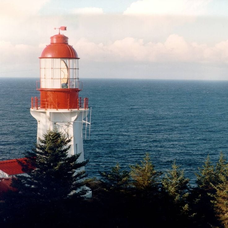
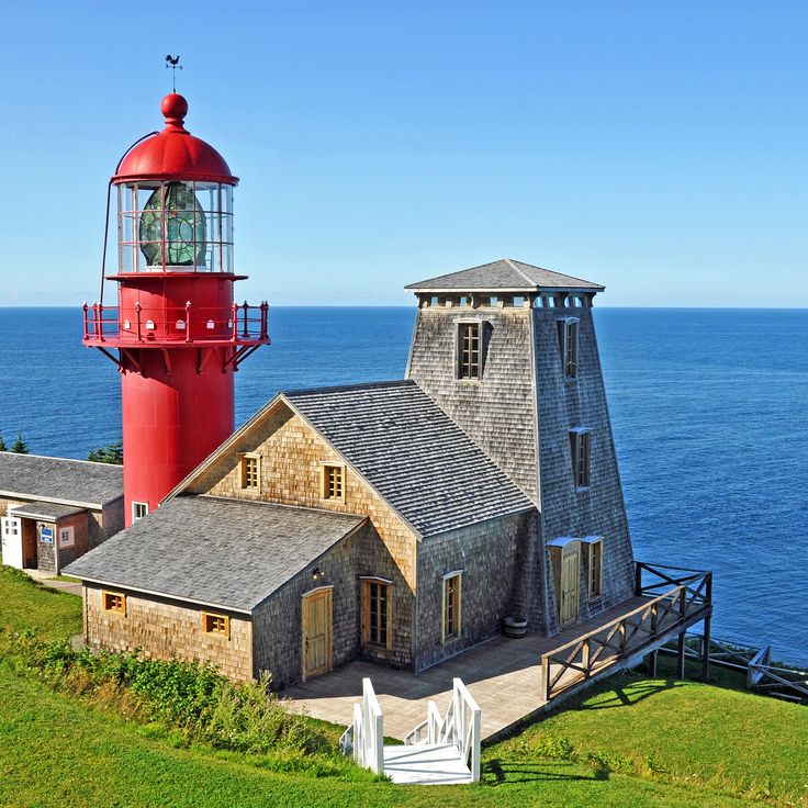
The lighthouse has stood since 1880 on the coast of the Gaspé Peninsula, marking the entrance to the bay from the Gulf of Saint Lawrence. Its white tower rises above a point of land where wind and waves shape the shore. The structure was built to guide ships through this often foggy passage. The building shows the maritime construction methods of the 19th century in this region. From here you can look out over the expanse of water and watch how light moves across the bay. The site gives a sense of the life of keepers who once worked here and watched over sea traffic.
The Langara lighthouse has stood since 1913 on the northern tip of the Haida Gwaii archipelago, guiding ships through the waters between British Columbia and Alaska. The white tower watches over a stretch of coast where the Pacific Ocean brings unexpected currents and frequent fog. Fishermen and cargo vessels have relied on this light for more than a century when passing the northernmost islands. The solitude of the site shapes the view: rough rock, waves breaking against the cliffs, and behind it the dense green of the temperate rainforest.