Chest opened
+${chestReward.xp} XP
Explorer
NOUVEAU ×${chestReward.collectible.quantity}
tapez pour fermer

See the monuments around you in AR Open chests in the app

Around Us is built for your phone — point your camera at the streets and discover the monuments and places around you in augmented reality. Around Us is built for your phone — chests unlock when you walk, explore and capture nearby places.

Enable Location

We need your location to show you interesting places around you

Discover nearby places

Find interesting locations and hidden gems around you

Precise directions

Get accurate directions and distances to places

Your location is never shared with other users. It's only used when you tap the location button.

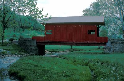
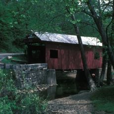
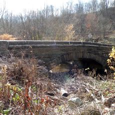
Ebenezer Covered Bridge

Log in to your account

Start exploring — it's free

Trusted by 85,642 travelers worldwide

Continue with Google
Continue with Apple
or

We will send you a code to connect

By continuing, you accept our Terms and Conditions and our Privacy Policy

Check your inbox

We've sent a pincode in your inbox. Please enter the code below.

Discussion Reviews 1 Photos
1.5k Popularity

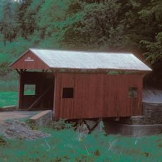
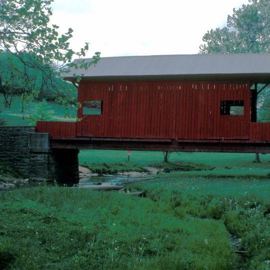
Ebenezer Covered Bridge, Historic covered bridge in Mingo Creek County Park, Pennsylvania, US.

The Ebenezer Covered Bridge is a red wooden structure with side windows set within a traditional timber frame design. The structure crosses a creek bed in the park and displays the craftsmanship typical of 19th-century bridge builders.

The structure was originally built elsewhere and relocated to the park in 1977 to make room for a highway expansion. During the move, it received steel reinforcement and new wooden decking to extend its life.

Pennsylvania maintains 213 covered bridges, with Ebenezer representing the traditional queenpost truss design that characterizes early American transportation infrastructure.

Access is through a large parking area at the county park near the western entrance to the grounds. The location is easy to find and the area is open to visitors without restrictions.

The bridge shares the park with another historic wooden bridge, creating a rare setting where visitors can see two preserved examples side by side. This pairing makes it one of few locations where such direct comparison is possible.

The community of curious travelers

AroundUs brings together thousands of curated places, local tips, and hidden gems, enriched daily by 60,000 contributors worldwide.
Start exploring
Location
GPS coordinates
40.19111,-80.04111
Latest update
August 30, 2026 21:33
Around this place
Black Horse Tavern
United States of America

Black Horse Tavern

9 mi
Edward G. Acheson House
United States of America

Edward G. Acheson House

5.8 mi
Beallsville Historic District
United States of America

Beallsville Historic District

8.8 mi
Henry Covered Bridge
United States of America

Henry Covered Bridge

1.5 mi
Abernathy Field Station
United States of America

Abernathy Field Station

8.5 mi
Elizabeth Locks & Dam
United States of America

Elizabeth Locks & Dam

9 mi
Huffman Distillery and Chopping Mill
United States of America

Huffman Distillery and Chopping Mill

4.9 mi
Scenery Hill Historic District
United States of America

Scenery Hill Historic District

7.5 mi
Charleroi-Monessen Bridge
United States of America

Charleroi-Monessen Bridge

7.7 mi
Charleroi Locks & Dam
United States of America

Charleroi Locks & Dam

8.1 mi
David Longwell House
United States of America

David Longwell House

5.9 mi
Charleroi Historic District
United States of America

Charleroi Historic District

8.1 mi
Enoch Wright House
United States of America

Enoch Wright House

4.1 mi
Samuel Brownlee House
United States of America

Samuel Brownlee House

4.7 mi
James Thome Farm
United States of America

James Thome Farm

6.2 mi
Frank L. Ross Farm
United States of America

Frank L. Ross Farm

6.4 mi
Bethel African American Episcopal Church of Monongahela City
United States of America

Bethel African American Episcopal Church of Monongahela City

5.9 mi
Dager-Wonsettler Farmstead
United States of America

Dager-Wonsettler Farmstead

7 mi
Cerl Wright Covered Bridge
United States of America

Cerl Wright Covered Bridge

2.3 mi
Ringland Tavern
United States of America

Ringland Tavern

7.5 mi
Bridge in Jefferson Borough
United States of America

Bridge in Jefferson Borough

8 mi
Dusmal House
United States of America

Dusmal House

5.9 mi
First National Bank of Charleroi
United States of America

First National Bank of Charleroi

8.4 mi
Thomas Munce House
United States of America

Thomas Munce House

7.3 mi
Martin Farmstead
United States of America

Martin Farmstead

6.7 mi
Doak-Little House
United States of America

Doak-Little House

7.8 mi
John McMillan's Log School
United States of America

John McMillan's Log School

9 mi
Moses Little Tavern
United States of America

Moses Little Tavern

8.3 mi
Show the full map
Reviews
Share your experience

No review yet

Discussions
Start a discussion...

No discussion yet

« Ebenezer Covered Bridge - Historic covered bridge in Mingo Creek County Park, Pennsylvania, US » is provided by Around Us (aroundus.com). Images and texts are derived from Wikimedia project under a Creative Commons license. You are allowed to copy, distribute, and modify copies of this page, under the conditions set by the license, as long as this note is clearly visible.

Discover hidden gems everywhere you go!

From secret cafés to breathtaking viewpoints, skip the crowded tourist spots and find places that match your style. Our app makes it easy with voice search, smart filtering, route optimization, and insider tips from travelers worldwide. Download now for the complete mobile experience.
Around Us App Screenshot

A unique approach to discovering new places

Le Figaro

All the places worth exploring

France Info

A tailor-made excursion in just a few clicks

20 Minutes

Around Us
Travel Guide & Maps
Download

Send to your phone

QR Code
1

Open the camera app on your mobile.

2

Point at the QR code with your camera. A notification will appear.

3

Tap the notification to open the link.