Enable Location

We need your location to show you interesting places around you

Discover nearby places

Find interesting locations and hidden gems around you

Precise directions

Get accurate directions and distances to places

Your location is never shared with other users. It's only used when you tap the location button.

Aqueduc de Fontenay

Log in to your account

Start exploring — it's free

Trusted by 61,973 travelers worldwide

Continue with Google
Continue with Apple
or

We will send you a code to connect

By continuing, you accept our Terms and Conditions and our Privacy Policy

Check your inbox

We've sent a pincode in your inbox. Please enter the code below.

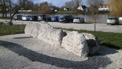
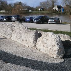
Aqueduc de Fontenay, Roman aqueduct ruins in Athée-sur-Cher, France.

The Aqueduc de Fontenay was an underground water line from Roman times that stretched from Bléré to Tours. The structure had vaulted channels and supporting walls designed to reliably transport water across this long distance.

The structure was built in the 1st century to supply water to the ancient Roman city of Caesarodunum, which is now Tours. This engineering work stood for many centuries and shows the technical abilities of the Romans in Gaul.

The aqueduct was part of a Roman system that moved water across long distances to supply the ancient city. Visitors can still observe the construction methods that reveal how essential water transport was to urban life.

The remains are partly underground and therefore difficult to see in their entirety. It is important to find out in advance where the most accessible parts of the structure are located and which areas require special attention.

The construction used local materials such as sand, gravel, and limestone that were plentiful in the region. This choice shows how Roman engineers adapted their building projects to the local environment.

The community of curious travelers

AroundUs brings together thousands of curated places, local tips, and hidden gems, enriched daily by 60,000 contributors worldwide.

Start exploring
Location
Address
La Boissière
GPS coordinates
47.33528,0.93528
Latest update
December 8, 2025 21:07
« Aqueduc de Fontenay - Roman aqueduct ruins in Athée-sur-Cher, France » is provided by Around Us (aroundus.com). Images and texts are derived from Wikimedia project under a Creative Commons license. You are allowed to copy, distribute, and modify copies of this page, under the conditions set by the license, as long as this note is clearly visible.

Discover hidden gems everywhere you go!

From secret cafés to breathtaking viewpoints, skip the crowded tourist spots and find places that match your style. Our app makes it easy with voice search, smart filtering, route optimization, and insider tips from travelers worldwide. Download now for the complete mobile experience.

Around Us App Screenshot

A unique approach to discovering new places

Le Figaro

All the places worth exploring

France Info

A tailor-made excursion in just a few clicks

20 Minutes

Around Us
Travel Guide & Maps
Download

Send to your phone

QR Code
1

Open the camera app on your mobile.

2

Point at the QR code with your camera. A notification will appear.

3

Tap the notification to open the link.