Chest opened
+${chestReward.xp} XP
Explorer
NOUVEAU ×${chestReward.collectible.quantity}
tapez pour fermer

See the monuments around you in AR Open chests in the app

Around Us is built for your phone — point your camera at the streets and discover the monuments and places around you in augmented reality. Around Us is built for your phone — chests unlock when you walk, explore and capture nearby places.

•

Enable Location

We need your location to show you interesting places around you

Discover nearby places

Find interesting locations and hidden gems around you

Precise directions

Get accurate directions and distances to places

Your location is never shared with other users. It's only used when you tap the location button.

Mount Parker

Log in to your account

Start exploring — it's free

Trusted by 93,128 travelers worldwide

Continue with Google
Continue with Apple
or

We will send you a code to connect

By continuing, you accept our Terms and Conditions and our Privacy Policy

Check your inbox

We've sent a pincode in your inbox. Please enter the code below.

Mount Parker

Mount Parker, Mountain summit in Eastern District, Hong Kong

Mount Parker is a mountain summit rising 532 meters above sea level and overlooks Hong Kong Island's eastern region. Two radar domes on top are visible from many locations across the island.

The summit received its name from Admiral William Parker, a British naval officer who served during Hong Kong's colonial period. This naming reflects the maritime and political connections of that era.

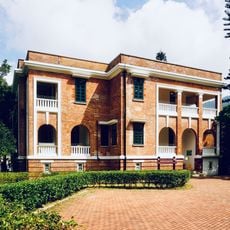
The Woodside Biodiversity Education Centre occupies a mansion from the 1920s where visitors discover exhibitions about Hong Kong's natural ecosystems and wildlife. The center helps people understand the environmental relationships that shape the surrounding landscape today.

Mount Parker Road is access-restricted: motorcycles, cars, bicycles and electric scooters need a special permit, and offenders may be fined. Hikers can start from Quarry Bay MTR Exit A via Quarry Bay Street, or take green minibus 32, 32A or 33 from Tai Koo MTR Exit B to Nam Fung Sun Chuen and walk up. A concrete road leads to the 518 m northeast sub-peak with the radar station; the 532 m trigonometrical station stands on the southwest main peak.

In 1903 the Hong Kong camellia's relative Camellia crapnelliana was first found on this peak, and the native Camellia hongkongensis still grows here. The mountain's upper slopes also carry aviation radar installations, and the 1892 cable car that once linked Quarry Bay with Tai Fung Au was dismantled in 1932.

The community of curious travelers

AroundUs brings together thousands of curated places, local tips, and hidden gems, enriched daily by 93,128 contributors worldwide.

Start exploring
Location
Elevation above the sea
532 m
GPS coordinates
22.26597,114.21988
Latest update
October 28, 2026 13:52
Reviews
Share your experience

No review yet

Discussions
Start a discussion...

No discussion yet

« Mount Parker - Mountain summit in Eastern District, Hong Kong » is provided by Around Us (aroundus.com). Images and texts are derived from Wikimedia project under a Creative Commons license. You are allowed to copy, distribute, and modify copies of this page, under the conditions set by the license, as long as this note is clearly visible.

Discover hidden gems everywhere you go!

From secret cafés to breathtaking viewpoints, skip the crowded tourist spots and find places that match your style. Our app makes it easy with voice search, smart filtering, route optimization, and insider tips from travelers worldwide. Download now for the complete mobile experience.

Around Us App Screenshot
❝

A unique approach to discovering new places❞

— Le Figaro

❝

All the places worth exploring❞

— France Info

❝

A tailor-made excursion in just a few clicks❞

— 20 Minutes

Around Us
Travel Guide & Maps
Download

Send to your phone

QR Code
1

Open the camera app on your mobile.

2

Point at the QR code with your camera. A notification will appear.

3

Tap the notification to open the link.