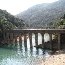
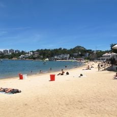
Tai Tam Country Park, Country park in Tai Tam, Southern District, Hong Kong.
Tai Tam Country Park covers 1,315 hectares, about one fifth of Hong Kong Island, stretching from Jardine's Lookout in the north to the Twins and Stanley Gap Road in the south, and from Wong Nai Chung Gap west to Tai Tam Road east. Its peaks include Mount Parker (531 m), Mount Butler, Violet Hill and Jardine's Lookout. Granite lies to the north and volcanic rock of the Jurassic Tsuen Wan Volcanic Group to the south. The reservoirs sit within the park, and a wooden sign at the entrance reads "TAI TAM COUNTRY PARK" beneath two large Chinese characters.
The four reservoirs were built between 1888 and 1917 to supply water to Hong Kong's growing population. This infrastructure was crucial to the city's development in the early 20th century.
The park's name comes from the Tai Tam valley, whose Cantonese name (daai6 taam4) means "big pool", a reference to the reservoirs held in its catchments. The Tai Tam Waterworks Heritage Trail links 22 colonial-era waterworks structures, among them dams, aqueducts and valve houses, and walkers can follow it between the reservoirs.
The park is best reached by public bus from the North Point or Central areas, with multiple routes serving different entrance points. The trails are most enjoyable on dry days since paths can become slippery after rain.
The park holds several structures built during World War II, including anti-aircraft platforms and bunkers used in combat. These remains tell the story of the conflict between British and Japanese forces during the occupation.
The community of curious travelers
AroundUs brings together thousands of curated places, local tips, and hidden gems, enriched daily by 93,974 contributors worldwide.