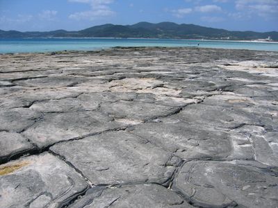
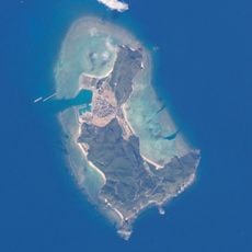
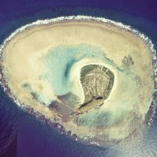
Tatami-ishi, Natural monument in Kumejima, Japan
Tatami-ishi is a rock formation along the south coast of Oujima, composed of thousands of geometrically shaped stones. These stone blocks feature pentagonal or hexagonal forms and stretch for about 250 meters along the shoreline.
The stone formation developed during the Miocene period when hot andesitic lava cooled and contracted. This slow cooling process caused natural cracks to form in a regular pattern, shaping the columnar structures visible today.
The name refers to traditional Japanese tatami floor mats, since the flat, uniform stone blocks lie side by side like mats. This connection to household design shows how people have drawn comparisons between natural forms and domestic spaces.
The best time to visit is during low tide, when the stone surfaces are exposed and fully visible. Checking tide schedules before your trip is important, since accessibility depends heavily on daily water levels.
The stones have a natural inward tilt that resembles the slope of a traditional house roof. This unexpected angle may have been caused by uneven lava cooling patterns and adds an extra dimension to the formation's geometry.
Location: Kumejima
Part of: Top 100 Geological Sites in Japan
GPS coordinates: 26.33603,126.82405
Latest update: December 9, 2025 20:23
Naminoue Shrine
85.5 km
Former Japanese Navy Underground Headquarters
86.7 km
11th Regional Coast Guard Headquarters
85.8 km
Tsuji
85.6 km
Tonaki Island
32.1 km
DMM Kariyushi Aquarium
84.9 km
Okinawa Prefecture Government Building
86.6 km
Naminoue Beach
85.6 km
Tsushima-maru Memorial Museum
85.7 km
Fukushūen
86 km
Shiseibyō
85.6 km
Fukaji Island
50.4 km
Gokoku-ji
86.4 km
Idesuna Jima Range
28.3 km
Mie Castle
85 km
Yamashita First Cave Site Park
86.1 km
Naha City Museum of History
86.4 km
Tomari Ōhashi Bridge
86.2 km
Kamejiro Senaga and the People's History Museum
85.9 km
Tomaritaka Bridge
86.8 km
Prefectural Office Crossing
86.6 km
Wakasa Seaside Park
86 km
Okinawa Postal Museum
86.6 km
琉球温泉
83.5 km
Āra Beach
5.5 km
Tomariminato Bridge
86.7 km
Hateno Beach
6.2 km
Ryukyu King Sho Family Related Documents
86.4 kmVisited this place? Tap the stars to rate it and share your experience / photos with the community! Try now! You can cancel it anytime.
Discover hidden gems everywhere you go!
From secret cafés to breathtaking viewpoints, skip the crowded tourist spots and find places that match your style. Our app makes it easy with voice search, smart filtering, route optimization, and insider tips from travelers worldwide. Download now for the complete mobile experience.
A unique approach to discovering new places❞
— Le Figaro
All the places worth exploring❞
— France Info
A tailor-made excursion in just a few clicks❞
— 20 Minutes