Enable Location

We need your location to show you interesting places around you

Discover nearby places

Find interesting locations and hidden gems around you

Precise directions

Get accurate directions and distances to places

Your location is never shared with other users. It's only used when you tap the location button.

Sawel Mountain

Log in to your account

Start exploring — it's free

Trusted by 62,869 travelers worldwide

Continue with Google
Continue with Apple
or

We will send you a code to connect

By continuing, you accept our Terms and Conditions and our Privacy Policy

Check your inbox

We've sent a pincode in your inbox. Please enter the code below.

Sawel Mountain

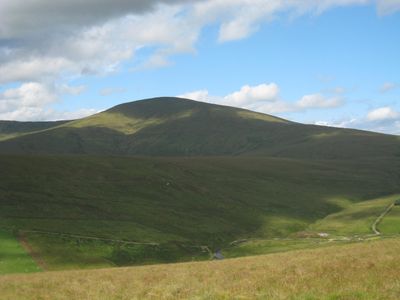
Sawel Mountain, Mountain summit in County Londonderry, United Kingdom

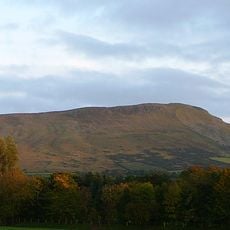
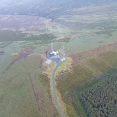
Sawel Mountain is the highest peak of the Sperrin Mountains in Northern Ireland, rising to 678 meters above the surrounding land. The bare summit is covered in moorland heath and offers expansive views across surrounding valleys and distant mountain ranges.

The mountain became the site of a tragic aircraft crash in 1944 when a Royal Navy plane went down in harsh weather. This event remains part of the region's wartime history and is still remembered by local people.

The mountain holds deep roots in Irish mythology, particularly through its connection to ancient stories about Queen Méabh, shaping how locals view the place. This legendary heritage gives the landscape a sense of cultural weight that visitors can feel while exploring the heights.

The ascent follows a fence line trail from a small parking area near the trailhead where space is limited. Check weather conditions before visiting, as the exposed summit can be difficult to navigate when fog or rain rolls in.

The River Faughan springs from this summit, flowing down to become one of the region's major waterways. The slopes show crystalline limestone formations alongside rare alpine plants that thrive only at this elevation.

The community of curious travelers

AroundUs brings together thousands of curated places, local tips, and hidden gems, enriched daily by 60,000 contributors worldwide.

Start exploring
Elevation above the sea
678 m
GPS coordinates
54.81970,-7.03940
Latest update
December 10, 2025 15:49
Around this place
Ulster American Folk Park
United Kingdom

Ulster American Folk Park

26 km
Slieve Gallion
United Kingdom

Slieve Gallion

20.4 km
Lissan House
United Kingdom

Lissan House

24.3 km
Dungiven Castle
United Kingdom

Dungiven Castle

13.9 km
Altinaghree Castle
United Kingdom

Altinaghree Castle

14.8 km
Roe Valley Country Park
United Kingdom

Roe Valley Country Park

23.7 km
Aughlish
United Kingdom

Aughlish

8.5 km
Benbradagh
United Kingdom

Benbradagh

17.5 km
Mullaghcarn
United Kingdom

Mullaghcarn

19.5 km
Stewart Castle
United Kingdom

Stewart Castle

24.3 km
Patrician Hall
United Kingdom

Patrician Hall

24.8 km
Newtownstewart Town Hall
United Kingdom

Newtownstewart Town Hall

24.4 km
Tirnony Dolmen
United Kingdom

Tirnony Dolmen

22.8 km
Clogherny Meenerrigal
United Kingdom

Clogherny Meenerrigal

13.3 km
Court Tomb von Ervey
United Kingdom

Court Tomb von Ervey

18.4 km
Steinkiste von Newtownstewart
United Kingdom

Steinkiste von Newtownstewart

24.4 km
Limavady Baptist Church
United Kingdom

Limavady Baptist Church

26.1 km
Straidarran House Clagan Road Claudy Co Londonderry Bt47 4db
United Kingdom

Straidarran House Clagan Road Claudy Co Londonderry Bt47 4db

8.4 km
St Mary's Roman Catholic Church 7 Cavanakeeran Road Pomeroy Dungannon Co Tyrone
United Kingdom

St Mary's Roman Catholic Church 7 Cavanakeeran Road Pomeroy Dungannon Co Tyrone

26 km
St. Columba's Church Draperstown Magherafelt Co.londonderry
United Kingdom

St. Columba's Church Draperstown Magherafelt Co.londonderry

16.6 km
Glencush Bridge Ballyheather Road Strabane Co.tyrone Bt82
United Kingdom

Glencush Bridge Ballyheather Road Strabane Co.tyrone Bt82

21.4 km
Wilson House 28 Spout Road Dergalt Strabane Co. Tyrone Bt82 8nb
United Kingdom

Wilson House 28 Spout Road Dergalt Strabane Co. Tyrone Bt82 8nb

24.8 km
Newtownstewart Old Bridge Douglas Road Newtownstewart Co. Tyrone Bt78 4ne
United Kingdom

Newtownstewart Old Bridge Douglas Road Newtownstewart Co. Tyrone Bt78 4ne

24.3 km
Wellbrook Beetling Mill
United Kingdom

Wellbrook Beetling Mill

22.4 km
Ballykelly Presbyterian Church Main Street Ballykelly Limavady Co Londonderry Bt49 9hs
United Kingdom

Ballykelly Presbyterian Church Main Street Ballykelly Limavady Co Londonderry Bt49 9hs

25 km
Newtownstewart Library
United Kingdom

Newtownstewart Library

24.6 km
Banagher Old Church
United Kingdom

Banagher Old Church

10.9 km
Beaghmore
United Kingdom

Beaghmore

14.7 km
Show the full map
« Sawel Mountain - Mountain summit in County Londonderry, United Kingdom » is provided by Around Us (aroundus.com). Images and texts are derived from Wikimedia project under a Creative Commons license. You are allowed to copy, distribute, and modify copies of this page, under the conditions set by the license, as long as this note is clearly visible.

Discover hidden gems everywhere you go!

From secret cafés to breathtaking viewpoints, skip the crowded tourist spots and find places that match your style. Our app makes it easy with voice search, smart filtering, route optimization, and insider tips from travelers worldwide. Download now for the complete mobile experience.

Around Us App Screenshot

A unique approach to discovering new places

Le Figaro

All the places worth exploring

France Info

A tailor-made excursion in just a few clicks

20 Minutes

Around Us
Travel Guide & Maps
Download

Send to your phone

QR Code
1

Open the camera app on your mobile.

2

Point at the QR code with your camera. A notification will appear.

3

Tap the notification to open the link.