·

Enable Location

We need your location to show you interesting places around you

Discover nearby places

Find interesting locations and hidden gems around you

Precise directions

Get accurate directions and distances to places

Your location is never shared with other users. It's only used when you tap the location button.

Broomfield Park

Log in to your account

Start exploring — it's free

Trusted by 62,649 travelers worldwide

Continue with Google
Continue with Apple
or

We will send you a code to connect

By continuing, you accept our Terms and Conditions and our Privacy Policy

Check your inbox

We've sent a pincode in your inbox. Please enter the code below.

Broomfield Park

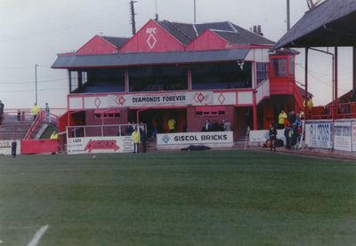
Broomfield Park, Football stadium in Airdrie, Scotland.

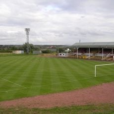
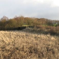
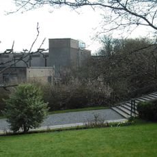
Broomfield Park was a football stadium in Airdrie situated within a natural depression in the landscape of North Lanarkshire. The pitch measured 61 meters in width with stands positioned close to the playing surface on all sides.

The stadium was established in 1892 and served as home to Airdrieonians Football Club until operations ended in 1994. Throughout its existence it underwent several upgrades including the addition of floodlights and a roof structure over one section.

The ground was home to Airdrieonians for more than a century and formed a central point for the local community on match days. The close layout of the stands created a direct connection between supporters and the action on the pitch.

The ground sits in a natural depression which affects sightlines from different areas of the stadium. Visitors should know that the venue has been closed since the mid-1990s and is no longer in active use.

The stadium gained a reputation for its acoustic properties because the close proximity of the stands to the pitch amplified crowd noise. This narrow design meant that every match felt immediate and visceral for supporters.

The community of curious travelers

AroundUs brings together thousands of curated places, local tips, and hidden gems, enriched daily by 60,000 contributors worldwide.

Start exploring
Inception
1892
Official opening
1892
Capacity
12620
GPS coordinates
55.86348,-3.97805
Latest update
December 10, 2025 20:10
Around this place
Cliftonhill
United Kingdom

Cliftonhill

2.1 km
Carfin Grotto
United Kingdom

Carfin Grotto

6.6 km
Monkland Canal
United Kingdom

Monkland Canal

2.5 km
Airdrie Public Observatory
United Kingdom

Airdrie Public Observatory

379 m
Dalziel Park
United Kingdom

Dalziel Park

7.5 km
Drumpellier country park
United Kingdom

Drumpellier country park

4.9 km
Summerlee, Museum of Scottish Industrial Life
United Kingdom

Summerlee, Museum of Scottish Industrial Life

3.3 km
Airdrie Library
United Kingdom

Airdrie Library

476 m
Coatbridge College
United Kingdom

Coatbridge College

2.4 km
Coatbridge Library
United Kingdom

Coatbridge Library

3.2 km
Airdrie, Stirling Street, Sir John Wilson Town Hall
United Kingdom

Airdrie, Stirling Street, Sir John Wilson Town Hall

415 m
Bellshill Central Parish church
United Kingdom

Bellshill Central Parish church

5.5 km
Coatbridge, Dunbeth Road, Municipal Buildings
United Kingdom

Coatbridge, Dunbeth Road, Municipal Buildings

2.7 km
Airdrie Town House
United Kingdom

Airdrie Town House

384 m
Whitelaw memorial fountain
United Kingdom

Whitelaw memorial fountain

3.2 km
Showcase Cinemas Coatbridge
United Kingdom

Showcase Cinemas Coatbridge

5.7 km
Motherwell, Forgewood, Jerviston Railway Viaduct
United Kingdom

Motherwell, Forgewood, Jerviston Railway Viaduct

6.7 km
Monkland Canal, Coatbridge Cross Railway Bridge
United Kingdom

Monkland Canal, Coatbridge Cross Railway Bridge

3.2 km
Coatdyke, Centenary Avenue, Railway Viaduct
United Kingdom

Coatdyke, Centenary Avenue, Railway Viaduct

1.5 km
Monkland Canal, Caledonian Railway Bridge, Coatbridge
United Kingdom

Monkland Canal, Caledonian Railway Bridge, Coatbridge

3.3 km
Airdrie, Wellwynd, West Parish Church Of Scotland
United Kingdom

Airdrie, Wellwynd, West Parish Church Of Scotland

506 m
Big Heids
United Kingdom

Big Heids

3.2 km
Airdrie, 16 And 18 North Bridge Street
United Kingdom

Airdrie, 16 And 18 North Bridge Street

685 m
Coatbridge, Hozier Street, St Mary's Church, Presbytery
United Kingdom

Coatbridge, Hozier Street, St Mary's Church, Presbytery

3 km
New Monkland, Parish Church, Watch House
United Kingdom

New Monkland, Parish Church, Watch House

2.8 km
Coatbridge, 1 Main Street, Airdrie Savings Bank
United Kingdom

Coatbridge, 1 Main Street, Airdrie Savings Bank

3.2 km
Coatbridge Central Station building
United Kingdom

Coatbridge Central Station building

3.3 km
Luggie Viaduct
United Kingdom

Luggie Viaduct

5.8 km
Show the full map
« Broomfield Park - Football stadium in Airdrie, Scotland » is provided by Around Us (aroundus.com). Images and texts are derived from Wikimedia project under a Creative Commons license. You are allowed to copy, distribute, and modify copies of this page, under the conditions set by the license, as long as this note is clearly visible.

Discover hidden gems everywhere you go!

From secret cafés to breathtaking viewpoints, skip the crowded tourist spots and find places that match your style. Our app makes it easy with voice search, smart filtering, route optimization, and insider tips from travelers worldwide. Download now for the complete mobile experience.

Around Us App Screenshot

A unique approach to discovering new places

Le Figaro

All the places worth exploring

France Info

A tailor-made excursion in just a few clicks

20 Minutes

Around Us
Travel Guide & Maps
Download

Send to your phone

QR Code
1

Open the camera app on your mobile.

2

Point at the QR code with your camera. A notification will appear.

3

Tap the notification to open the link.