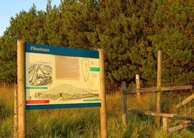
Pikestones, Neolithic burial site in Anglezarke, England
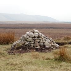
Pikestones is a chambered cairn in Anglezarke, built from five gritstone slabs that form a burial chamber approximately 4.5 meters long and 1 meter wide. The slabs range from 1.6 to 2.7 meters in length and represent typical Neolithic construction methods.
Construction took place between 3400 and 2400 BC during the Neolithic period, when early farming communities established communal burial sites in northern England. This era marks the shift toward settled societies with organized burial practices.
The double wall design at the northern end reflects how Neolithic builders created entrance spaces for communal tombs. This architectural choice shows how early farming communities organized their sacred burial grounds.
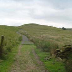
Access is on foot from the parking area at Jepson's Gate, though the path becomes slippery during wet weather. Sturdy footwear is recommended for the walk to the site.
A circular stone arrangement surrounding the chamber spans approximately 25 meters in diameter, suggesting an earlier circular structure. This type of ring design appears in other cairns from the same era, indicating shared building principles.
Location: Anglezarke
Website: https://historicengland.org.uk/listing/the-list/list-entry/1009120
GPS coordinates: 53.64990,-2.56578
Latest update: December 14, 2025 15:01
Anglezarke Reservoir
1.5 km
Rivington Hall
2.8 km
Rivington Hall Barn
2.8 km
Great Hill
2.7 km
Round Loaf
1.5 km
Rivington Unitarian Chapel
2.7 km
Rivington Church
2.8 km
Yarrow Reservoir
1.5 km
Upper Rivington Reservoir
2.4 km
Hurst Hill
695 m
High Bullough Reservoir
863 m
Canal Bridge Number 76
3.2 km
Two Archways And Associated Stone Staircases And Retaining Walls In Rivington Gardens At Sd 6390 1422
3.2 km
Loggia, Summerhouse And Associated Staircases In Rivington Gardens At Sd 6392 1431
3.1 km
Lever Bridge, Staircases And A Summer House In Rivington Gardens At Sd 6384 1422
3.2 km
Pigeon Tower, Staircases, Stone Arches, Stone Screen And Two Gate Piers In Rivington Gardens At Sd 6397 1433
3.1 km
Wellington Bomber Z8799 Crash site Memorial, Rivington
726 m
Wilcocks Farmhouse
1.7 km
Canal Bridge Number 75 At Sd 595 163
3.2 km
Manor House
594 m
Bellhouse Circa 10 Metres West Of Church Of Holy Trinity
2.8 km
Hall O' Th' Hill
3.2 km
Warth Farmhouse
2.3 km
Moses Cocker's Farmhouse
2.2 km
Leeds Liverpool Canal, Railway Bridge Over Leeds Liverpool Canal At Sd 595 162
3.3 km
Mounting Block In School Yard Circa 15 Metres West Of Rivington School
2.8 km
Great House Farmhouse And Cottage
3.3 km
Fisher House
2.7 kmVisited this place? Tap the stars to rate it and share your experience / photos with the community! Try now! You can cancel it anytime.
Discover hidden gems everywhere you go!
From secret cafés to breathtaking viewpoints, skip the crowded tourist spots and find places that match your style. Our app makes it easy with voice search, smart filtering, route optimization, and insider tips from travelers worldwide. Download now for the complete mobile experience.
A unique approach to discovering new places❞
— Le Figaro
All the places worth exploring❞
— France Info
A tailor-made excursion in just a few clicks❞
— 20 Minutes