Enable Location

We need your location to show you interesting places around you

Discover nearby places

Find interesting locations and hidden gems around you

Precise directions

Get accurate directions and distances to places

Your location is never shared with other users. It's only used when you tap the location button.

Round Loaf

Log in to your account

Start exploring — it's free

Trusted by 62,440 travelers worldwide

Continue with Google
Continue with Apple
or

We will send you a code to connect

By continuing, you accept our Terms and Conditions and our Privacy Policy

Check your inbox

We've sent a pincode in your inbox. Please enter the code below.

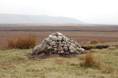
Round Loaf, Bronze Age burial mound in Anglezarke, England

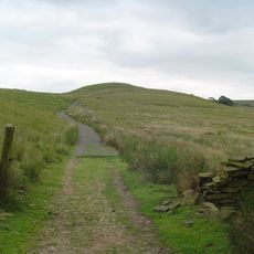
The Round Loaf is an oval-shaped earthen mound in Anglezarke that extends about 73 meters from north to south and about 66 meters from east to west. The mound rises between 3.6 and 5.5 meters above the surrounding land.

This burial mound was built between 2400 and 1500 BC during the late Neolithic and Bronze Age periods to serve as a grave. It became a protected monument in 1954 to preserve it for future study.

The mound shows how prehistoric people buried their dead and created places to remember them. These burial sites were important landmarks that communities could see and recognize for many generations.

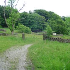
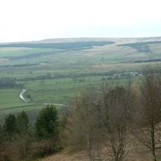
This site sits in open countryside and can be reached from walking paths that pass through the Anglezarke area. When visiting, keep your distance from the mound itself and respect the marked boundary around it.

The interior of the mound has never been excavated, so the original burial remains untouched beneath the soil. Flint tools found at the eroded summit suggest that prehistoric people left traces of their work on top.

The community of curious travelers

AroundUs brings together thousands of curated places, local tips, and hidden gems, enriched daily by 60,000 contributors worldwide.

Start exploring
Location
GPS coordinates
53.65920,-2.54927
Latest update
December 12, 2025 14:20
Around this place
Winter Hill
United Kingdom

Winter Hill

3.9 km
Anglezarke Reservoir
United Kingdom

Anglezarke Reservoir

3 km
Rivington Hall
United Kingdom

Rivington Hall

3.8 km
Rivington Hall Barn
United Kingdom

Rivington Hall Barn

3.8 km
Hollinshead Hall
United Kingdom

Hollinshead Hall

3.1 km
Great Hill
United Kingdom

Great Hill

1.2 km
Rivington Unitarian Chapel
United Kingdom

Rivington Unitarian Chapel

3.9 km
Rivington Church
United Kingdom

Rivington Church

4 km
Yarrow Reservoir
United Kingdom

Yarrow Reservoir

2.8 km
Ward's Reservoir
United Kingdom

Ward's Reservoir

4 km
Upper Rivington Reservoir
United Kingdom

Upper Rivington Reservoir

3.7 km
Hurst Hill
United Kingdom

Hurst Hill

1 km
Pikestones
United Kingdom

Pikestones

1.5 km
High Bullough Reservoir
United Kingdom

High Bullough Reservoir

2.3 km
Two Archways And Associated Stone Staircases And Retaining Walls In Rivington Gardens At Sd 6390 1422
United Kingdom

Two Archways And Associated Stone Staircases And Retaining Walls In Rivington Gardens At Sd 6390 1422

4 km
Loggia, Summerhouse And Associated Staircases In Rivington Gardens At Sd 6392 1431
United Kingdom

Loggia, Summerhouse And Associated Staircases In Rivington Gardens At Sd 6392 1431

3.9 km
Lever Bridge, Staircases And A Summer House In Rivington Gardens At Sd 6384 1422
United Kingdom

Lever Bridge, Staircases And A Summer House In Rivington Gardens At Sd 6384 1422

4 km
Wilcocks Farmhouse
United Kingdom

Wilcocks Farmhouse

2.7 km
Pigeon Tower, Staircases, Stone Arches, Stone Screen And Two Gate Piers In Rivington Gardens At Sd 6397 1433
United Kingdom

Pigeon Tower, Staircases, Stone Arches, Stone Screen And Two Gate Piers In Rivington Gardens At Sd 6397 1433

3.9 km
Wellington Bomber Z8799 Crash site Memorial, Rivington
United Kingdom

Wellington Bomber Z8799 Crash site Memorial, Rivington

1.9 km
Bellhouse Circa 10 Metres West Of Church Of Holy Trinity
United Kingdom

Bellhouse Circa 10 Metres West Of Church Of Holy Trinity

4 km
Manor House
United Kingdom

Manor House

2 km
Warth Farmhouse
United Kingdom

Warth Farmhouse

2.5 km
Moses Cocker's Farmhouse
United Kingdom

Moses Cocker's Farmhouse

3 km
Fisher House
United Kingdom

Fisher House

3.9 km
Wishing Well In Corner Of Enclosure To Former Hollinshead Hall
United Kingdom

Wishing Well In Corner Of Enclosure To Former Hollinshead Hall

3.1 km
Milestone, Piccadilly Cottages
United Kingdom

Milestone, Piccadilly Cottages

2.7 km
Milestone, Old Man's Hill
United Kingdom

Milestone, Old Man's Hill

2.8 km
Show the full map
« Round Loaf - Bronze Age burial mound in Anglezarke, England » is provided by Around Us (aroundus.com). Images and texts are derived from Wikimedia project under a Creative Commons license. You are allowed to copy, distribute, and modify copies of this page, under the conditions set by the license, as long as this note is clearly visible.

Discover hidden gems everywhere you go!

From secret cafés to breathtaking viewpoints, skip the crowded tourist spots and find places that match your style. Our app makes it easy with voice search, smart filtering, route optimization, and insider tips from travelers worldwide. Download now for the complete mobile experience.

Around Us App Screenshot

A unique approach to discovering new places

Le Figaro

All the places worth exploring

France Info

A tailor-made excursion in just a few clicks

20 Minutes

Around Us
Travel Guide & Maps
Download

Send to your phone

QR Code
1

Open the camera app on your mobile.

2

Point at the QR code with your camera. A notification will appear.

3

Tap the notification to open the link.