Enable Location

We need your location to show you interesting places around you

Discover nearby places

Find interesting locations and hidden gems around you

Precise directions

Get accurate directions and distances to places

Your location is never shared with other users. It's only used when you tap the location button.

Snuff Mills

Log in to your account

Start exploring — it's free

Trusted by 66,654 travelers worldwide

Continue with Google
Continue with Apple
or

We will send you a code to connect

By continuing, you accept our Terms and Conditions and our Privacy Policy

Check your inbox

We've sent a pincode in your inbox. Please enter the code below.

Snuff Mills
Discussion Reviews 1 Photos
6.9k Popularity

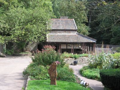
Snuff Mills, Historic park with mill ruins in Fishponds, United Kingdom

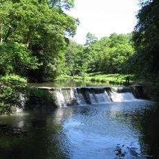
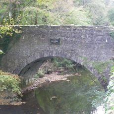
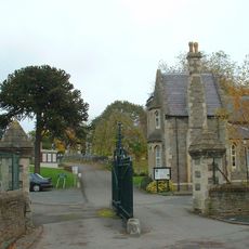
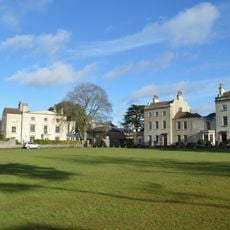
Snuff Mills is a park in Bristol that runs along the River Frome, with wooded paths, open meadows, and the stone remains of a mill building on the riverbank. The green space sits in a shallow valley, giving it a sheltered feel with tree cover on most sides.

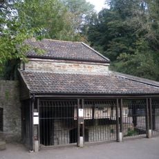
A tobacco processing operation set up here in the 1700s, using the flow of the River Frome to power the machinery that ground tobacco leaves into snuff. When industrial activity in the valley faded, the mill was left behind, and its stone structure gradually became the ruin visible today.

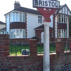
The name of the park comes directly from the snuff mill that once operated on this stretch of the River Frome. Today, local families and dog walkers use the riverside paths as part of their daily routines, making it a genuinely lived-in green space.

The park is easy to reach on foot from several surrounding neighborhoods, and parking is available close by for those arriving by car. Some paths run over uneven ground near the river, so sturdy footwear is a good idea, especially after rain.

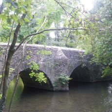
The River Frome at this point is shallow enough in places to see the riverbed clearly, and brown trout have been spotted in the water. The river here is one of the few stretches in the Bristol area where the water runs visibly clean over stones.

The community of curious travelers

AroundUs brings together thousands of curated places, local tips, and hidden gems, enriched daily by 60,000 contributors worldwide.

Start exploring
Location
GPS coordinates
51.48580,-2.54058
Latest update
March 3, 2026 10:10
Around this place
The Dower House
United Kingdom

The Dower House

858 m
MoD Abbey Wood
United Kingdom

MoD Abbey Wood

2.3 km
Stoke Park
United Kingdom

Stoke Park

1.1 km
Purdown BT Tower
United Kingdom

Purdown BT Tower

1.5 km
Glenside Museum
United Kingdom

Glenside Museum

195 m
St Matthias
United Kingdom

St Matthias

754 m
Frome Valley Walkway
United Kingdom

Frome Valley Walkway

522 m
Oldbury Court Estate
United Kingdom

Oldbury Court Estate

1 km
Eastville Park
United Kingdom

Eastville Park

1.7 km
Church of Holy Trinity, Stapleton
United Kingdom

Church of Holy Trinity, Stapleton

1.1 km
St John the Baptist, Frenchay
United Kingdom

St John the Baptist, Frenchay

1.7 km
Church of St Mary
United Kingdom

Church of St Mary

853 m
Frenchay Bridge
United Kingdom

Frenchay Bridge

1.6 km
Unitarian Chapel
United Kingdom

Unitarian Chapel

1.8 km
Fishponds War Memorial
United Kingdom

Fishponds War Memorial

953 m
Greenbank Cemetery Pair Of Attached Mortuary Chapels
United Kingdom

Greenbank Cemetery Pair Of Attached Mortuary Chapels

2 km
Wickham Bridge
United Kingdom

Wickham Bridge

793 m
Friends' Meeting House
United Kingdom

Friends' Meeting House

2.1 km
Boundary Marker Located At The Junction Of Thicket Road And High Street
United Kingdom

Boundary Marker Located At The Junction Of Thicket Road And High Street

1.8 km
Group Of Three Tombs Approximately 2 Metres North West Of Church Of St Mary
United Kingdom

Group Of Three Tombs Approximately 2 Metres North West Of Church Of St Mary

834 m
Entrance Gates And Piers To Greenbank Cemetery And Railings To East
United Kingdom

Entrance Gates And Piers To Greenbank Cemetery And Railings To East

2.2 km
Glenside University Campus
United Kingdom

Glenside University Campus

189 m
The Old House And Adjoining Coach House And Stables
United Kingdom

The Old House And Adjoining Coach House And Stables

1.8 km
Drinking Fountain In Fishponds Park
United Kingdom

Drinking Fountain In Fishponds Park

970 m
Stapleton Mill, Snuff Mills Park
United Kingdom

Stapleton Mill, Snuff Mills Park

141 m
Milestone At St 6127 7590, Approximately 40 Metres North East Of South Entrance To Purdown Hospital
United Kingdom

Milestone At St 6127 7590, Approximately 40 Metres North East Of South Entrance To Purdown Hospital

1.4 km
Numbers 11, 13 And 15 And Attached Garden Wall
United Kingdom

Numbers 11, 13 And 15 And Attached Garden Wall

901 m
Milestone, Fishponds Road, jct with Oakdene Avenue
United Kingdom

Milestone, Fishponds Road, jct with Oakdene Avenue

1.5 km
Show the full map
Reviews
Share your experience

No review yet

Discussions
Start a discussion...

No discussion yet

« Snuff Mills - Historic park with mill ruins in Fishponds, United Kingdom » is provided by Around Us (aroundus.com). Images and texts are derived from Wikimedia project under a Creative Commons license. You are allowed to copy, distribute, and modify copies of this page, under the conditions set by the license, as long as this note is clearly visible.

Discover hidden gems everywhere you go!

From secret cafés to breathtaking viewpoints, skip the crowded tourist spots and find places that match your style. Our app makes it easy with voice search, smart filtering, route optimization, and insider tips from travelers worldwide. Download now for the complete mobile experience.

Around Us App Screenshot

A unique approach to discovering new places

Le Figaro

All the places worth exploring

France Info

A tailor-made excursion in just a few clicks

20 Minutes

Around Us
Travel Guide & Maps
Download

Send to your phone

QR Code
1

Open the camera app on your mobile.

2

Point at the QR code with your camera. A notification will appear.

3

Tap the notification to open the link.