Purdown BT Tower

Log in to your account

AroundUs is a community-driven map of interesting places, built by curious explorers like you. It grows with every review, story, and photo you share.
Connect to save your favorite spots, contribute locations, and create personalized routes.
Continue with Google
Continue with Apple
Continue with X
Continue with Facebook
Continue with email
By continuing, you accept our Terms and Conditions and our Privacy Policy
Create an account

Purdown BT Tower

Add to collection
Map
Suggest a change
Share

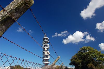
Purdown BT Tower, Telecommunications tower in Lockleaze, Bristol, England

Purdown BT Tower is a telecommunications tower in Lockleaze, Bristol, standing about 70 meters tall with a reinforced concrete structure. Multiple microwave dishes and antennas are mounted across its exterior, helping transmit signals throughout the city.

A temporary steel-lattice tower was built in 1961 to serve early telecommunications needs in Bristol. In 1970, it was replaced by the current concrete structure as part of Britain's expanding communications infrastructure.

Local residents affectionately call the tower 'Cups and Saucers' because of the distinctive circular dishes mounted at various heights along its structure. This nickname reflects how the community has made sense of the tower's unusual appearance as part of everyday life in Bristol.

The tower transmits FM radio stations including Kiss FM and Classic FM while providing mobile phone coverage across the city. It is visible from street level and serves as a working communications hub for the region.

In 2008, British Telecom removed all outdated microwave dishes, significantly changing the tower's visual appearance. This renovation marked the shift from microwave relay systems to modern fiber optic technology.

Location: City of Bristol

Floors above the ground: 8

GPS coordinates: 51.48530,-2.56278

Latest update: December 10, 2025 15:50

Photos
Around this place
The Dower House
United Kingdom

The Dower House

1.5 km
MoD Abbey Wood
United Kingdom

MoD Abbey Wood

2 km
Stoke Park
United Kingdom

Stoke Park

858 m
Snuff Mills
United Kingdom

Snuff Mills

1.5 km
Glenside Museum
United Kingdom

Glenside Museum

1.4 km
St Matthias
United Kingdom

St Matthias

2.3 km
Frome Valley Walkway
United Kingdom

Frome Valley Walkway

1 km
St Werburgh's Church, Bristol
United Kingdom

St Werburgh's Church, Bristol

1.8 km
Church of the Holy Trinity with St Edmund
United Kingdom

Church of the Holy Trinity with St Edmund

1.7 km
Eastville Park
United Kingdom

Eastville Park

1.1 km
Church of Holy Trinity, Stapleton
United Kingdom

Church of Holy Trinity, Stapleton

692 m
St Peter and St Paul, Bristol
United Kingdom

St Peter and St Paul, Bristol

2.3 km
Easton Jamia Mosque
United Kingdom

Easton Jamia Mosque

2 km
Church of St Mary
United Kingdom

Church of St Mary

2.3 km
Greenbank Cemetery Pair Of Attached Mortuary Chapels
United Kingdom

Greenbank Cemetery Pair Of Attached Mortuary Chapels

1.8 km
Wickham Bridge
United Kingdom

Wickham Bridge

903 m
Müllers & The George Müller Museum
United Kingdom

Müllers & The George Müller Museum

1.5 km
Public Lavatory On South East Corner Of Horfield Common
United Kingdom

Public Lavatory On South East Corner Of Horfield Common

1.6 km
Brunel House Muller Homes (City Of Bristol College)
United Kingdom

Brunel House Muller Homes (City Of Bristol College)

1.5 km
Group Of Three Tombs Approximately 2 Metres North West Of Church Of St Mary
United Kingdom

Group Of Three Tombs Approximately 2 Metres North West Of Church Of St Mary

2.3 km
Junction 3 Library
United Kingdom

Junction 3 Library

2.3 km
Two Pillars
United Kingdom

Two Pillars

2 km
Entrance Gates And Piers To Greenbank Cemetery And Railings To East
United Kingdom

Entrance Gates And Piers To Greenbank Cemetery And Railings To East

2 km
Glenside University Campus
United Kingdom

Glenside University Campus

1.4 km
Stapleton Mill, Snuff Mills Park
United Kingdom

Stapleton Mill, Snuff Mills Park

1.4 km
Milestone At St 6127 7590, Approximately 40 Metres North East Of South Entrance To Purdown Hospital
United Kingdom

Milestone At St 6127 7590, Approximately 40 Metres North East Of South Entrance To Purdown Hospital

570 m
Bristol North Baths
United Kingdom

Bristol North Baths

2.3 km
Milestone, Fishponds Road, jct with Oakdene Avenue
United Kingdom

Milestone, Fishponds Road, jct with Oakdene Avenue

1.6 km
Show the full map
Reviews

Visited this place? Tap the stars to rate it and share your experience / photos with the community! Try now! You can cancel it anytime.

« Purdown BT Tower - Telecommunications tower in Lockleaze, Bristol, England » is provided by Around Us (aroundus.com). Images and texts are derived from Wikimedia project under a Creative Commons license. You are allowed to copy, distribute, and modify copies of this page, under the conditions set by the license, as long as this note is clearly visible.

Discover hidden gems everywhere you go!

From secret cafés to breathtaking viewpoints, skip the crowded tourist spots and find places that match your style. Our app makes it easy with voice search, smart filtering, route optimization, and insider tips from travelers worldwide. Download now for the complete mobile experience.

Around Us App Screenshot

A unique approach to discovering new places

Le Figaro

All the places worth exploring

France Info

A tailor-made excursion in just a few clicks

20 Minutes