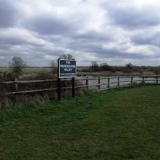
Cranham Marsh, Nature reserve in Havering, Greater London, England
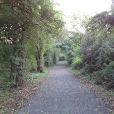
Cranham Marsh is a nature reserve in Havering featuring diverse habitats including woodlands, wet meadows, and marsh areas spread across roughly 15 hectares. Walking through the reserve, you encounter different landscape types that support various plants and animals adapted to each environment.
The area was once part of extensive marshlands that covered much of Essex before urban growth transformed the region. The reserve today preserves a remnant of those historic wetlands that have largely vanished elsewhere.
The reserve is managed by Essex Wildlife Trust and serves as a space where visitors learn about the wildlife living nearby through guided activities and community programs. This connection between people and nature helps residents understand the importance of protecting local habitats.
You can reach the reserve via footpaths from Park Drive and The Chase, with Upminster tube station providing the nearest public transport link. The ground becomes muddy after rain, so wear appropriate footwear depending on recent weather conditions.
The reserve provides habitat for the rare bee species Macropis europaea, which is difficult to spot but thrives in this protected area where few other places in Britain support it. The presence of this bee indicates the ecological value that often goes unnoticed by casual visitors.
The community of curious travelers
AroundUs brings together thousands of curated places, local tips, and hidden gems, enriched daily by 60,000 contributors worldwide.