Church of Saint Credan

Log in to your account

AroundUs is a community-driven map of interesting places, built by curious explorers like you. It grows with every review, story, and photo you share.
Connect to save your favorite spots, contribute locations, and create personalized routes.
Continue with Google
Continue with Apple
Continue with X
Continue with Facebook
Continue with email
By continuing, you accept our Terms and Conditions and our Privacy Policy
Create an account
Add to collection
Map
Suggest a change
Share

Church of Saint Credan, Medieval parish church in Sancreed, Cornwall, England.

The Church of Saint Credan is a medieval parish church in Sancreed built with sturdy granite walls in traditional Cornish style. The building shares its grounds with several other protected structures including stone crosses and historic gate-piers.

The building dates to the medieval period and was designated Grade II* listed status, recognizing its national architectural importance. This protection requires careful maintenance and preserves the structure's distinctive character for future generations.

The church is named after Saint Credan and serves the local community as a place for worship and gatherings. It shapes the village character and remains central to the rhythm of community life in Sancreed.

The grounds are accessed through 18th-century granite gate-piers that show fine craftsmanship and remain in good condition. The church sits in a quiet village setting best explored on foot, with plenty of time to view the surroundings.

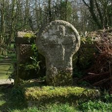
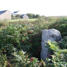
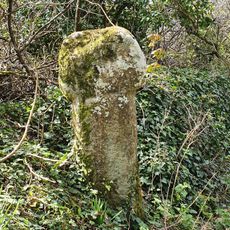
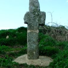
The grounds feature several ancient stone crosses that reflect different periods and local craftsmanship traditions. These weathered monuments give insight into centuries of local history layered into the churchyard landscape.

Location: Sancreed

GPS coordinates: 50.10810,-5.60939

Latest update: December 14, 2025 16:42

Photos
Around this place
Boscawen-Un
United Kingdom

Boscawen-Un

2.2 km
Carn Euny
United Kingdom

Carn Euny

1.8 km
Drift Reservoir
United Kingdom

Drift Reservoir

1.3 km
Caer Bran
United Kingdom

Caer Bran

1.3 km
Bartinney Castle
United Kingdom

Bartinney Castle

2.6 km
Sancreed Beacon
United Kingdom

Sancreed Beacon

639 m
Brane Barrow
United Kingdom

Brane Barrow

2.2 km
Standing stone known as the 'Blind Fiddler', 405m south east of Lesbew Farm
United Kingdom

Standing stone known as the 'Blind Fiddler', 405m south east of Lesbew Farm

1.3 km
Two standing stones known as the Long Stones, 280m south east of Higher Drift Farm
United Kingdom

Two standing stones known as the Long Stones, 280m south east of Higher Drift Farm

2 km
Tresvennack Pillar
United Kingdom

Tresvennack Pillar

2.6 km
Wayside cross in Sancreed churchyard, 10m east of the church
United Kingdom

Wayside cross in Sancreed churchyard, 10m east of the church

23 m
Brane Cross
United Kingdom

Brane Cross

1.3 km
Cross at approximately 10 metres south of Church of St Credan
United Kingdom

Cross at approximately 10 metres south of Church of St Credan

22 m
Milestone Approximately 135M Se Of The Firs
United Kingdom

Milestone Approximately 135M Se Of The Firs

1.4 km
Milestone At Sw 43110 28029, 87M North-East Of Lower Hendra Cottages
United Kingdom

Milestone At Sw 43110 28029, 87M North-East Of Lower Hendra Cottages

1.7 km
Wayside cross-head in Sancreed churchyard on churchyard wall by west gate
United Kingdom

Wayside cross-head in Sancreed churchyard on churchyard wall by west gate

19 m
Milestone At Sw402275
United Kingdom

Milestone At Sw402275

2.6 km
Leswidden Stone, 370m south west of Leswidden
United Kingdom

Leswidden Stone, 370m south west of Leswidden

2.5 km
Trevorgans Cross
United Kingdom

Trevorgans Cross

2.7 km
Guide Post At Sw406317
United Kingdom

Guide Post At Sw406317

2.8 km
Milestone At  Sw443288
United Kingdom

Milestone At Sw443288

2.4 km
Guide Post At Sw407318
United Kingdom

Guide Post At Sw407318

2.8 km
Trembath Cross
United Kingdom

Trembath Cross

2.9 km
Tremethick Cross, 760m east of Tremethick Farm
United Kingdom

Tremethick Cross, 760m east of Tremethick Farm

2.9 km
The Old Toll House
United Kingdom

The Old Toll House

2.6 km
Milestone Approximately 98M E Of Carthew Cottages
United Kingdom

Milestone Approximately 98M E Of Carthew Cottages

2.3 km
Round, courtyard house settlement and field system 140m WNW of Goldherring
United Kingdom

Round, courtyard house settlement and field system 140m WNW of Goldherring

1.5 km
Sancreed War Memorial
United Kingdom

Sancreed War Memorial

28 m
Show the full map
Reviews

Visited this place? Tap the stars to rate it and share your experience / photos with the community! Try now! You can cancel it anytime.

« Church of Saint Credan - Medieval parish church in Sancreed, Cornwall, England » is provided by Around Us (aroundus.com). Images and texts are derived from Wikimedia project under a Creative Commons license. You are allowed to copy, distribute, and modify copies of this page, under the conditions set by the license, as long as this note is clearly visible.

Discover hidden gems everywhere you go!

From secret cafés to breathtaking viewpoints, skip the crowded tourist spots and find places that match your style. Our app makes it easy with voice search, smart filtering, route optimization, and insider tips from travelers worldwide. Download now for the complete mobile experience.

Around Us App Screenshot

A unique approach to discovering new places

Le Figaro

All the places worth exploring

France Info

A tailor-made excursion in just a few clicks

20 Minutes