·

Enable Location

We need your location to show you interesting places around you

Discover nearby places

Find interesting locations and hidden gems around you

Precise directions

Get accurate directions and distances to places

Your location is never shared with other users. It's only used when you tap the location button.

Drift Reservoir

Log in to your account

Start exploring — it's free

Trusted by 62,656 travelers worldwide

Continue with Google
Continue with Apple
or

We will send you a code to connect

By continuing, you accept our Terms and Conditions and our Privacy Policy

Check your inbox

We've sent a pincode in your inbox. Please enter the code below.

Drift Reservoir

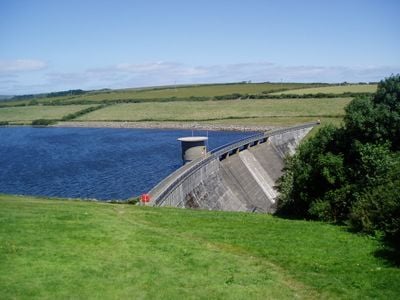
Drift Reservoir, lake in Cornwall

Drift Reservoir is a large water body in southwest Cornwall surrounded by open fields and gentle hills. The shallow edges with exposed mud provide ideal feeding grounds for wading birds, and walking paths run along the shores for visitors to explore.

The dam was completed in 1961 after planning began in 1938 but was delayed by the Second World War. Beneath the water lie the remains of an old settlement called Trewidden Vean, which was flooded when the reservoir was created.

The name comes from the small village of Drift nearby. The water attracts fishermen and birdwatchers who regularly visit the shores, making it a gathering point for people interested in nature and outdoor activities.

A large free car park at the southern end offers good views of the water and access to walking paths. The paths are wide and easy to follow, making them suitable for families and visitors of all ages.

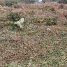
After dry periods, parts of old houses and roads from the sunken settlement become visible above the water surface. These remains from the 'lost valley' show how dramatically the landscape transformed when the area was flooded.

The community of curious travelers

AroundUs brings together thousands of curated places, local tips, and hidden gems, enriched daily by 60,000 contributors worldwide.

Start exploring
Location
Location
Elevation above the sea
85 m
GPS coordinates
50.10800,-5.59100
Latest update
February 9, 2026 08:23
Around this place
Trereife House
United Kingdom

Trereife House

1.9 km
Trengwainton Garden
United Kingdom

Trengwainton Garden

2.6 km
YHA Penzance
United Kingdom

YHA Penzance

2.6 km
Caer Bran
United Kingdom

Caer Bran

2.6 km
Church of Saint Credan
United Kingdom

Church of Saint Credan

1.3 km
Lesingey Round
United Kingdom

Lesingey Round

2.3 km
Sancreed Beacon
United Kingdom

Sancreed Beacon

1.9 km
Standing stone known as the 'Blind Fiddler', 405m south east of Lesbew Farm
United Kingdom

Standing stone known as the 'Blind Fiddler', 405m south east of Lesbew Farm

1.4 km
Two standing stones known as the Long Stones, 280m south east of Higher Drift Farm
United Kingdom

Two standing stones known as the Long Stones, 280m south east of Higher Drift Farm

1 km
Tresvennack Pillar
United Kingdom

Tresvennack Pillar

1.6 km
St. Peter's Church
United Kingdom

St. Peter's Church

2.8 km
Wayside cross in Sancreed churchyard, 10m east of the church
United Kingdom

Wayside cross in Sancreed churchyard, 10m east of the church

1.3 km
Cross at approximately 10 metres south of Church of St Credan
United Kingdom

Cross at approximately 10 metres south of Church of St Credan

1.3 km
Brane Cross
United Kingdom

Brane Cross

2.5 km
Trengwainton House
United Kingdom

Trengwainton House

2.5 km
Milestone At Sw 43110 28029, 87M North-East Of Lower Hendra Cottages
United Kingdom

Milestone At Sw 43110 28029, 87M North-East Of Lower Hendra Cottages

1.3 km
Milestone Approximately 135M Se Of The Firs
United Kingdom

Milestone Approximately 135M Se Of The Firs

2.1 km
Kerris Manor Farmhouse Including Front Garden Walls And Rear Courtyard Walls
United Kingdom

Kerris Manor Farmhouse Including Front Garden Walls And Rear Courtyard Walls

2.3 km
Wayside cross-head in Sancreed churchyard on churchyard wall by west gate
United Kingdom

Wayside cross-head in Sancreed churchyard on churchyard wall by west gate

1.3 km
Milestone At  Sw443288
United Kingdom

Milestone At Sw443288

1.1 km
Kerris Cross
United Kingdom

Kerris Cross

2.3 km
The Old Toll House
United Kingdom

The Old Toll House

1.6 km
Milestone Approximately 98M E Of Carthew Cottages
United Kingdom

Milestone Approximately 98M E Of Carthew Cottages

2.4 km
Trembath Cross
United Kingdom

Trembath Cross

1.6 km
Tremethick Cross, 760m east of Tremethick Farm
United Kingdom

Tremethick Cross, 760m east of Tremethick Farm

1.7 km
Sancreed War Memorial
United Kingdom

Sancreed War Memorial

1.3 km
Round, courtyard house settlement and field system 140m WNW of Goldherring
United Kingdom

Round, courtyard house settlement and field system 140m WNW of Goldherring

2.5 km
Milestone, Trereife, Penzance by-pass
United Kingdom

Milestone, Trereife, Penzance by-pass

2.2 km
Show the full map
« Drift Reservoir - lake in Cornwall » is provided by Around Us (aroundus.com). Images and texts are derived from Wikimedia project under a Creative Commons license. You are allowed to copy, distribute, and modify copies of this page, under the conditions set by the license, as long as this note is clearly visible.

Discover hidden gems everywhere you go!

From secret cafés to breathtaking viewpoints, skip the crowded tourist spots and find places that match your style. Our app makes it easy with voice search, smart filtering, route optimization, and insider tips from travelers worldwide. Download now for the complete mobile experience.

Around Us App Screenshot

A unique approach to discovering new places

Le Figaro

All the places worth exploring

France Info

A tailor-made excursion in just a few clicks

20 Minutes

Around Us
Travel Guide & Maps
Download

Send to your phone

QR Code
1

Open the camera app on your mobile.

2

Point at the QR code with your camera. A notification will appear.

3

Tap the notification to open the link.