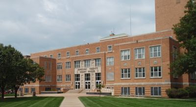
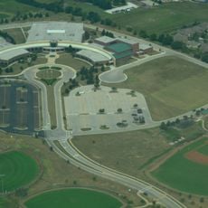
Johnson County, County administration center in Olathe, Kansas, US
Johnson County is an administrative region in eastern Kansas with its seat in Olathe. The area features flat prairie terrain interrupted by several waterways, including Kill Creek and Turkey Creek, with scattered wooded sections along the streams.
The region was named after Methodist preacher Thomas Johnson in 1855 and became a site of confrontations between anti-slavery and pro-slavery groups. These tensions shaped the early settlement years and reflected the national conflicts that led to the Civil War.
The county contains numerous educational institutions across eight school districts, offering diverse programs and resources for students of all ages.
Public services can be accessed through an online mapping system that shows administrative boundaries and geographic information. Offices in Olathe provide various administrative services for residents, available both in person and digitally.
The administrative system allows residents to trace voting precinct boundaries and geographic features digitally. This transparency helps with orientation during local elections and regional matters.
Location: Kansas
Inception: 1855
Capital city: Olathe
Reference: JO
Shares border with: Wyandotte County, Miami County, Jackson County, Cass County, Leavenworth County, Franklin County, Douglas County
Website: http://jocogov.org
GPS coordinates: 38.86670,-94.86670
Latest update: December 11, 2025 22:57
United Methodist Church of the Resurrection
19.6 km
Sprint World Headquarters Campus
19 km
Blue Valley Northwest High School
14.4 km
Joe’s Kansas City Bar-B-Que
29.1 km
Blue Valley West High School
15.5 km
Shawnee Methodist Mission
28 km
Overland Park Arboretum and Botanical Gardens
16.9 km
Museum at Prairiefire
18.7 km
Indian Hills Country Club
25.8 km
Freedom's Frontier National Heritage Area
17.4 km
Mahaffie House
6.3 km
Nerman Museum of Contemporary Art
13.7 km
Hindu Temple and Cultural Center of Kansas City
18.6 km
Vox Theatre
29.6 km
K-7 Bridge
21.4 km
Highway 2 Bridge
15.4 km
William Thomas Turner Barn
11.4 km
Arthur F. McClure II Archives and University Museum
16.7 km
Sunflower Village Historic District
14.5 km
I. O. Pickering House
4.1 km
Johnson County Museum
20.6 km
Albert Ott House
4.6 km
Rio Theatre
21.5 km
H.W. Gates Funeral Home
30.7 km
Franklin R. Lanter House
3.9 km
Museum of Deaf History, Arts and Culture
5 km
Martin Van Buren Parker House
3.7 km
Interstate 435 Bridge
21 kmVisited this place? Tap the stars to rate it and share your experience / photos with the community! Try now! You can cancel it anytime.
Discover hidden gems everywhere you go!
From secret cafés to breathtaking viewpoints, skip the crowded tourist spots and find places that match your style. Our app makes it easy with voice search, smart filtering, route optimization, and insider tips from travelers worldwide. Download now for the complete mobile experience.
A unique approach to discovering new places❞
— Le Figaro
All the places worth exploring❞
— France Info
A tailor-made excursion in just a few clicks❞
— 20 Minutes